

RESEARCH· ·1970·
RESEARCH· ·1970·
RESEARCH· ·1970·

You also want an ePaper? Increase the reach of your titles
YUMPU automatically turns print PDFs into web optimized ePapers that Google loves.
..<br />
A<br />
B<br />
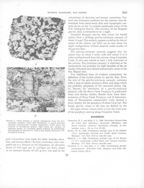
FIGURE 3.-Pinto Diorite, a typical orthogneiss from the Precambrian<br />
complex, Little Belt Mountains. A, hand specimen<br />
showing characteristic mottled appearance. Dark areas are<br />
clusters of hornblende grains; light areas are clusters of<br />
andesine grains. B, actinolite grains rimmed by hornblende.<br />
Photographs by Richard B. Taylor and Sandra Brennan, U.S.<br />
Geological Survey.<br />
port. Corrections were made for drift, latitude, elevation,<br />
and terrain effects. Terrain corrections were computed<br />
out to a distance of 167 kilometers. An elevation<br />
factor of 0.06 mgal per ft ( milligal per foot), based<br />
on an assumed density of 2.67 g/cm 3 , was used in the<br />
WITKIND, KLEINKOPF, AND KEEFER<br />
B65<br />
calculations of elevation and terrain corrections. V ertical<br />
and horizontal positions for the stations were determined<br />
from bench-mark data and topographic controls<br />
shown on the 7ljz-minute quadrangle maps of the<br />
U.S. Geological Survey. The accuracy of the Bouguer<br />
gravity data is estimated to be 1 mgal.<br />
Complete Bouguer gravity data across the buried<br />
pluton show a striking gmvity-minimum anomaly of<br />
about 15 mgal. The anomaly 'appeal'S to define the later'al<br />
extent of the pluton, but little can be said wbout the<br />
depth configumtion without detailed model studies of<br />
the gravity data.<br />
The gravity-minimum anoma,ly suggests that the<br />
pluton may be about 3 miles wide and extend 4 to 6<br />
miles northeastward from the outcrop along Carpenter<br />
Creek. It also may extend at least 1 mile southwest of<br />
the outcrop. The minimum anomaly is distorted at the<br />
northeastern end probably by high densities of the intensely<br />
deformed and altered metamorphic rocks in the<br />
San Miguel area.<br />
Two additional lines of evidence substantiate the<br />
definition of the buried pluton by gravity data. First,<br />
the axis of the gravity-minimum anomaly coTrel.aJtes<br />
with a zone of quartz porphyry dikes and plugs which<br />
are probably apophyses of the concealed pluton (fig.<br />
2) . Second, the association of a gravity-minimum<br />
anomaly with the Snow Creek Porphyry is predictable<br />
from rock density studies. Results from three determinations<br />
of Snow Creek Porphyry and 10 determinations<br />
of Precambrian metamorphic rocks showed a<br />
lower density for the porphyry of about 0.2 g/cm 3 • The<br />
lowest gravity values in the area are defined by the<br />
-165-mgal contour closure whch is over the north part<br />
of the porphyry outcrop along Carpenter Creek.<br />
REFERENCES<br />
Catanzaro, E. J., and Kulp, J. L., 1964, Discordant zircons from<br />
the Little Belt (Montana), Beartooth (Montana), and<br />
Santa Catalina (Arizona) Mountains: Geochim. et Cos·<br />
mochim. Acta, v. 28, no. 4, p. 87-124.<br />
Keefer, W. R., 1969, Preliminary geologic map of the Neihart<br />
(7%') quadrangle, Cascade and Judith Basin Counties,<br />
Montana: U.S. Geol. Survey open-file map.<br />
Witkind, I. J., 1969, Preliminary geologic map of the Barker<br />
(7 1/ 2') quadrangle, Judith Basin and Cascade Counties,<br />
Montana: U.S. Geol. Survey open-file map.<br />
Woollard, G. P., and Rose, J. C., 1963, International gravity<br />
measurements: Wisconsin Univ. Geophys. and Polar Research<br />
Center, 518 p.


