

Download Volume II Accomplisments (28 Mb pdf). - IRIS
Download Volume II Accomplisments (28 Mb pdf). - IRIS
Download Volume II Accomplisments (28 Mb pdf). - IRIS

You also want an ePaper? Increase the reach of your titles
YUMPU automatically turns print PDFs into web optimized ePapers that Google loves.
Controlled-Source Seismic Investigation of the Generation and<br />
Collapse of a Batholith Complex, Coast Mountains, Western<br />
Canada<br />
K. Wang (Virginia Tech), J. A. Hole (Virginia Tech), A. L. Stephenson (University of Victoria), G. D. Spence (University of<br />
Victoria), K. C. Miller (Texas A&M University), S. H. Harder (University of Texas, El Paso), R. M. Clowes (University of<br />
British Columbia)<br />
In 2009, the BATHOLITHS project acquired a 400-km long refraction and wide-angle reflection seismic survey across the<br />
Coast Mountains of British Columbia, Canada, a Jurassic to Eocene continental arc batholith complex.<br />
Granitic batholiths created by magmatic differentiation in arcs above subduction zones make continental crust more felsic<br />
than the original materials derived from the mantle. However, differentiation from a mafic protolith results in a large volume of<br />
ultramafic residual that is petrologically part of the crust, not changing the bulk composition. This residue may reside hidden<br />
beneath the geophysical Moho, or it may have delaminated to sink into the mantle due to its relative density. Delamination may<br />
occur during subduction or during the collapse of the arc after subduction stops, and may coincide with a commonly observed<br />
late pulse of magmatism. As part of the BATHOLITHS multi-disciplinary investigation of these processes, traveltimes from the<br />
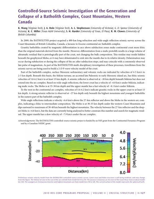
seismic survey are being used to build a 2-D P-wave velocity model of the crust.<br />
East of the batholith complex, surface Mesozoic sedimentary and volcanic rocks are indicated by velocities of 4-5 km/s to<br />
2-5 km depth. Beneath this basin, the Stikine terrane, an accreted late Paleozoic to early Mesozoic island arc, has felsic seismic<br />
velocities of 5.8-6.2 km/s to at least 15 km depth. A seismic reflector is observed at ~20 km depth beneath Stikinia but does not<br />
extend into the arc complex. Based on wide-angle reflections, the lower crust has a velocity of ~6.8 km/s under Stikinia, indicating<br />
mafic rocks. The Moho is at 35-38 km depth and the upper mantle has a fast velocity of ~8.1 km/s under Stikinia.<br />
To the west in the continental arc complex, velocities of 5.6-6.2 km/s indicate granitic rocks in the upper crust to at least 15<br />
km depth. A strong seismic reflector is observed at ~27 km depth only beneath the highest mountains and youngest batholiths<br />
in the eastern part of the batholith complex.<br />
Wide-angle reflections indicate a velocity 6.8 km/s, but the data are currently being analyzed to better constrain this number and search for magmatic residual.<br />
The upper mantle has a slow velocity of ~7.9 km/s under the arc complex.<br />
Acknowledgements: The BATHOLITHS controlled-source seismic project is funded by an NSF grant from the Continental Dynamics Program<br />
and by a Canadian NSERC grant.<br />
Preliminary seismic velocity model from the BATHOLITHS controlled-source seismic survey. Lower crust and Moho structure is still being modeled, and may change<br />
from this figure. The Stikine terrane to the east of the arc extends from model km 0 to 210. The Jurassic-Cretaceous arc lies west of the Coast Shear Zone at about model<br />
km 320. The youngest arc (Cretaceous-Eocene) and highest mountains are from model km 210 to 320. The curved surface of the model represents the spherical Earth.<br />
2010 <strong>IRIS</strong> Core Programs Proposal | <strong>Volume</strong> <strong>II</strong> | Crustal Structure | <strong>II</strong>-127


