

Download Volume II Accomplisments (28 Mb pdf). - IRIS
Download Volume II Accomplisments (28 Mb pdf). - IRIS
Download Volume II Accomplisments (28 Mb pdf). - IRIS

Create successful ePaper yourself
Turn your PDF publications into a flip-book with our unique Google optimized e-Paper software.
A Slab Remnant beneath the Gulf of California<br />
Hanneke Paulssen (Utrecht University), Xiaomei Zhang (Utrecht University), Jeannot Trampert (Utrecht University),<br />
Robert Clayton (California Institute of Technology)<br />
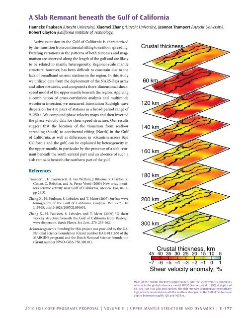
Active extension in the Gulf of California is characterized<br />
by the transition from continental rifting to seafloor spreading.<br />
Puzzling variations in the patterns of both tectonics and magmatism<br />
are observed along the length of the gulf and are likely<br />
to be related to mantle heterogeneity. Regional-scale mantle<br />
structure, however, has been difficult to constrain due to the<br />
lack of broadband seismic stations in the region. In this study<br />
we utilized data from the deployment of the NARS-Baja array<br />
and other networks, and computed a three-dimensional shearspeed<br />
model of the upper mantle beneath the region. Applying<br />
a combination of cross-correlation analysis and multimode<br />
waveform inversion, we measured interstation Rayleigh wave<br />
dispersion for 450 pairs of stations in a broad period range of<br />
9–250 s. We computed phase velocity maps and then inverted<br />
the phase-velocity data for shear-speed structure. Our results<br />
suggest that the location of the transition from seafloor<br />
spreading (South) to continental rifting (North) in the Gulf<br />
of California, as well as differences in volcanism across Baja<br />
California and the gulf, can be explained by heterogeneity in<br />
the upper mantle, in particular by the presence of a slab remnant<br />
beneath the south-central part and an absence of such a<br />
slab remnant beneath the northern part of the gulf.<br />
References<br />
Trampert J., H. Paulssen H, A. van Wettum, J. Ritsema, R. Clayton, R.<br />
Castro, C. Rebollar, and A. Perez-Vertti (2003) New array monitors<br />
seismic activity near Gulf of California, Mexico, Eos, 84, 4,<br />
pp 29,32.<br />
Zhang X., H. Paulssen, S. Lebedev, and T. Meier (2007) Surface wave<br />
tomography of the Gulf of California, Geophys. Res. Lett., 34,<br />
L15305, doi:10.1029/2007GL030631.<br />
Zhang X., H. Paulssen, S. Lebedev, and T. Meier (2009) 3D shear<br />
velocity structure beneath the Gulf of California from Rayleigh<br />
wave dispersion, Earth Planet. Sci. Lett., 279, 255-262.<br />
Acknowledgements: Funding for this project was provided by the U.S.<br />
National Science Foundation (Grant number EAR-0111650 of the<br />
MARGINS program) and the Dutch National Science Foundation<br />
(Grant number NWO-GOA-750.396.01).<br />
Crustal thickness<br />
60 km<br />
120 km<br />
140 km<br />
160 km<br />
180 km<br />
200 km<br />
300 km<br />
45<br />
Crustal thickness, km<br />
40<br />
35<br />
30<br />
25<br />
20<br />
15<br />
10<br />
−7 −6 −5 −4 −3 −2 −1 0 1<br />
Shear velocity anomaly, %<br />
5<br />
Maps of the crustal thickness (upper panel), and the shear velocity anomalies<br />
relative to the global reference model AK135 (Kennett et al., 1995) at depths of<br />
60, 100, 120, 160, 200, and 300 km. The slab remnant is imaged as the relatively<br />
high velocity anomaly beneath the south-central part of the Gulf of California at<br />
depths between roughly 120 and 160 km.<br />
2010 <strong>IRIS</strong> Core Programs Proposal | <strong>Volume</strong> <strong>II</strong> | Upper Mantle Structure and Dynamics | <strong>II</strong>-177


