

Download Volume II Accomplisments (28 Mb pdf). - IRIS
Download Volume II Accomplisments (28 Mb pdf). - IRIS
Download Volume II Accomplisments (28 Mb pdf). - IRIS

You also want an ePaper? Increase the reach of your titles
YUMPU automatically turns print PDFs into web optimized ePapers that Google loves.
Detailing a Shallow Crustal Earthquake Swarm beneath the Mogul,<br />
Nevada with PASSCAL RAMP Instrumentation<br />
Glenn Biasi, Kenneth D. Smith, John G. Anderson (University of Nevada, Reno)<br />
An anomalous swarm of shallow earthquakes began on <strong>28</strong> February 2008 beneath the suburban communities of Mogul and<br />
Somersett, Nevada, about 12 km west of downtown Reno. Initially the swarm consisted of a few earthquakes per week, but accelerated<br />
during March 2008 to include several felt events per day. Residents routinely reported feeling earthquakes of Ml 1.5 or smaller.<br />
Earthquake depths as shallow as 2 km were confirmed by a short-period station in the epicentral region. The relatively slow onset and<br />
sustained activity of the swarm provided time to request seismic instruments from the PASSCAL Rapid Array Mobilization Program<br />
(RAMP) pool. Four RAMP stations with broadband and strong-motion sensors were deployed in the epicentral area by 9 April 2008.<br />
The swarm began to accelerate in earnest in early April, with four Ml 3 or greater earthquakes on 15 April, two Ml 4 events on 24<br />
April, and what proved to be the mainshock, an Mw 5.0 earthquake at 06:40 on 26 April 2008. This earthquake produced component<br />
ground accelerations in excess of 0.8 g at two stations, and horizontal vector accelerations in excess of 1.1 g at one station [Anderson<br />
et al., 2009]. These ground motions caused widespread non-structural and content damage to residences in the area.<br />
Because of the social impact of the swarm and its potential to continue or even grow, six RAMP instruments deployed in central<br />
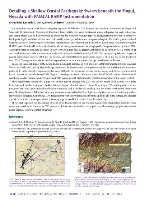
Nevada were relocated in early May to the epicentral area. An innovation in this deployment is that the RAMP stations were integrated<br />
by IP radio telemetry, beginning in late April 2008 into the permanent seismic monitoring network of the region operated<br />
by the University of Nevada Reno (UNR) (Figure 1). Antelope processing software at UNR allowed RAMP stations to be integrated<br />
seamlessly into the main network. This provided UNR personnel with highest-quality real-time information as the swarm evolved.<br />
The Mogul swarm continued at a high level of daily activity through June 2008, and did not return to an activity rate similar<br />
to its first week until mid-August. Double-difference hypocentral relocations (Figure 2) identify a NW-trending vertical structure,<br />
consistent with the mainshock and focal mechanisms, with a smaller NE-trending spur toward the north end of the rupture<br />
zone. The Mogul swarm did not occur on any known or suspected fault and geologic investigation has not identified any surface<br />
expression or structure. Continuous GPS data gathered with the event resolved motions up to 2.5 cm at the surface, but indicate<br />
a geodetic moment release approximately twice as large as would be expected from the seismicity.<br />
The Mogul sequence was the subject of a one-hour documentary by the National Geographic organization Naked Science<br />
series and aired by national cable-TV providers. Information is available at http://channel.nationalgeographic.com/series/<br />
naked-science/4232/Videos#tab-Overview.<br />
References<br />
Anderson, J. G., I. Tibuleac, A. Anooshehpoor, G. Biasi, K. Smith, and D. von Seggern (2009). Exceptional ground motions recorded during<br />
the April 26, 2008 Mw 5.0 earthquake in Mogul, Nevada, Bull. Seismol. Soc. Amer., 99, 3475-3486.<br />
Acknowledgements: The permanent network in western Nevada and easternmost California was supported by the United States Geological<br />
Survey under Cooperative Agreement 07HQAG0015.<br />
39°35'N<br />
Ü<br />
119°55'W<br />
MOGP<br />
119°50'W<br />
NOAA<br />
Relay<br />
39°35'N<br />
MOGB<br />
MOGN<br />
MOGF<br />
MOGW<br />
MOGC<br />
U. Nevada<br />
MOGA MOGE<br />
MOGL<br />
MOGR<br />
39°30'N<br />
39°30'N<br />
MOGD<br />
Relay<br />
1 0.5 0 1 2<br />
Miles<br />
119°55'W<br />
igure 1. PASSCAL RAMP stations and telemetry paths for the Mogul, Nevada earthquake<br />
swarm of 2008. Station MOGE used a cell modem, and station MOGR could<br />
not be telemetered by radio or cell because of line-of-sight issues. Seismic data was<br />
relayed to UNR and integrated into regional seismic network operations in real time.<br />
119°50'W<br />
Figure 2. Double-difference relocated earthquakes of the Mogul, Nevada earthquake<br />
swarm. The mainshock had an Mw of 5.0, but a local magnitude Ml 4.7.<br />
The mainshock hypocenter was approximately 3 km depth. Hypocenters do not<br />
coincide with any known fault or geologic structure. Downtown Reno, Nevada is<br />
near the east edge of the image.<br />
<strong>II</strong>-58 | 2010 <strong>IRIS</strong> Core Programs Proposal | <strong>Volume</strong> <strong>II</strong> | Earthquake Source Studies


