

Download Volume II Accomplisments (28 Mb pdf). - IRIS
Download Volume II Accomplisments (28 Mb pdf). - IRIS
Download Volume II Accomplisments (28 Mb pdf). - IRIS

You also want an ePaper? Increase the reach of your titles
YUMPU automatically turns print PDFs into web optimized ePapers that Google loves.
Segmented African Lithosphere beneath Anatolia Imaged by<br />
Teleseismic P-wave Tomography<br />
C. Berk Biryol (University of Arizona), Susan L. Beck (University of Arizona), George Zandt (University of Arizona), A.<br />
Arda Ozacar (Middle East Technical University)<br />
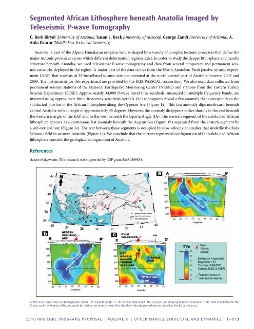
Anatolia, a part of the Alpine-Himalayan orogenic belt, is shaped by a variety of complex tectonic processes that define the<br />
major tectonic provinces across which different deformation regimes exist. In order to study the deeper lithosphere and mantle<br />
structure beneath Anatolia, we used teleseismic P-wave tomography and data from several temporary and permanent seismic<br />
networks deployed in the region. A major part of the data comes from the North Anatolian Fault passive seismic experiment<br />
(NAF) that consists of 39 broadband seismic stations operated at the north central part of Anatolia between 2005 and<br />
2008. The instruments for this experiment are provided by the <strong>IRIS</strong>-PASSCAL consortium. We also used data collected from<br />
permanent seismic stations of the National Earthquake Monitoring Center (NEMC) and stations from the Eastern Turkey<br />
Seismic Experiment (ETSE). Approximately 34,000 P-wave travel time residuals, measured in multiple frequency bands, are<br />
inverted using approximate finite-frequency sensitivity kernels. Our tomograms reveal a fast anomaly that corresponds to the<br />
subducted portion of the African lithosphere along the Cyprean Arc (Figure 1a). This fast anomaly dips northward beneath<br />
central Anatolia with an angle of approximately 45 degrees. However, the anomaly disappears rather sharply to the east beneath<br />
the western margin of the EAP and to the west beneath the Isparta Angle (IA). The western segment of the subducted African<br />
lithosphere appears as a continuous fast anomaly beneath the Aegean Sea (Figure 1b) separated from the eastern segment by<br />
a sub-vertical tear (Figure 1c). The tear between these segments is occupied by slow velocity anomalies that underlie the Kula<br />
Volcanic field in western Anatolia (Figure 1c). We conclude that the current segmented configuration of the subducted African<br />
lithosphere controls the geological configuration of Anatolia.<br />
References<br />
Acknowledgements: This research was supported by NSF grant EAR0309838.<br />
Vertical sections from our tomographic model. IA: Isparta Angle. a. The Cyprus slab and b. the Aegean slab dipping beneath Anatolia. c. The slab tear between the<br />
Cyprus and the Aegean slabs, occupied by raising hot mantle. Note that the slow velocity perturbations underlies the Kula volcanics.<br />
2010 <strong>IRIS</strong> Core Programs Proposal | <strong>Volume</strong> <strong>II</strong> | Upper Mantle Structure and Dynamics | <strong>II</strong>-173


