

Download Volume II Accomplisments (28 Mb pdf). - IRIS
Download Volume II Accomplisments (28 Mb pdf). - IRIS
Download Volume II Accomplisments (28 Mb pdf). - IRIS

Create successful ePaper yourself
Turn your PDF publications into a flip-book with our unique Google optimized e-Paper software.
High-resolution Images of Mantle-wedge Structure along the<br />
Western Hellenic Subduction Zone Using Scattered Teleseismic<br />
Waves<br />
F. D. Pearce (MIT), S. Rondenay (MIT), Maria Sachpazi (National Observatory of Athens), M. Charalampakis (National<br />
Observatory of Athens), A. Hosa (University of Edinburgh), J. Suckale (MIT), L. H. Royden (MIT)<br />
The Hellenic subduction zone is located<br />
in the east-central Mediterranean region<br />
and exhibits large variations in convergence<br />
rate along its western edge [McClusky et al.,<br />
2000]. Differences in the lithosphere entering<br />
the subduction zone are believed to drive the<br />
different rates of convergence. While recent<br />
work has shown evidence for subducted oceanic<br />
crust beneath southern Greece [Suckale<br />
et al., 2009], no detailed images of the mantle-wedge<br />
structure beneath northern Greece<br />
have been available to test this hypothesis.<br />
Here, we use high-resolution seismic images<br />
across northern and southern Greece to<br />
investigate differences in the subducted crust<br />
along the strike of the western Hellenic subduction<br />
zone. We deployed 40 broadband<br />
seismometers from the <strong>IRIS</strong> Passcal pool<br />
across Greece in a northern line (NL) and<br />
southern line (SL), each roughly perpendicular<br />
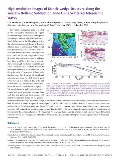
to the trench axis as shown in Figure 1a.<br />
We recorded over 50 high-quality teleseismic<br />
events with good azimuthal coverage from<br />
each line and processed them using a 2D<br />
migration algorithm based on the generalized<br />
radon transform. High-resolution images of perturbations in S-wave velocity reveal NE dipping low-velocity layers beneath<br />
both NL and SL as shown in Figure 1b. We interpret the ~10 km thick low-velocity layer beneath SL as subducted oceanic crust<br />
and the ~20 km thick low-velocity layer beneath NL as subducted continental crust. The two imaged subducted crusts connect<br />
smoothly with images from marine seismic surveys [Finetti, 2005] and show a progressive deepening of the oceanic crust of<br />
SL relative to the continental crust of NL (Figure 1c). We conclude that along strike changes in slab buoyancy cause differential<br />
rollback between the two segments, which helps drive the large difference in convergence rates along the western Hellenic subduction<br />
zone.<br />
References<br />
Figure 1: a) Map of study area showing location of southern segment (SS) and northern segment of<br />
western Hellenic subduction zone separated by the Cephalonia transform fault (CTF). White circles<br />
denote station locations for NL and SL deployments. b) Images of perturbation in S-wave velocity for SL<br />
(top) and NL (bottom) at -5% to +%5 (red to blue). Solid lines delineate top and bottom of low-velocity<br />
layer, and the Moho of overriding plate. X-axis is horizontal distance perpendicular to strike measured<br />
from the intersection of SL with the trench of southern segment (solid yellow line in a)). c) Comparison<br />
of subducted crusts imaged from marine seismics (dashed) and this study (solid) for NL (black) and SL<br />
(blue), with dots showing smooth interpolation.<br />
Finetti, I. R. (2005), Depth contour map of the Moho discontinuity in the central Mediterranean region from new CROP seismic data, in<br />
CROP PROJECT: Deep seismic exploration of the central Mediterranean and Italy, edited by I. R. Finetti, pp. 597-606, Elsevier B.V.,<br />
Amsterdam, The Netherlands.<br />
McClusky, S. et al. (2000), Global Positioning System constraints on plate kinematics and dynamics in the eastern Mediterranean and Caucasus,<br />
J. Geophys. Res., 105(B3), 5695-5719.<br />
Suckale J., S. Rondenay, M. Sachpazi, M. Charalampakis, A. Hosa, L. H. Royden (2009) High-resolution seismic imaging of the western<br />
Hellenic subduction zone using teleseismic scattered waves, Geophys. J. Int., 178(2), 775-791.<br />
Acknowledgements: This project was carried out as part of project MEDUSA, funded by the NSF Continental Dynamics Program, grant<br />
EAR-0409373.<br />
<strong>II</strong>-174 | 2010 <strong>IRIS</strong> Core Programs Proposal | <strong>Volume</strong> <strong>II</strong> | Upper Mantle Structure and Dynamics


