

Download Volume II Accomplisments (28 Mb pdf). - IRIS
Download Volume II Accomplisments (28 Mb pdf). - IRIS
Download Volume II Accomplisments (28 Mb pdf). - IRIS

You also want an ePaper? Increase the reach of your titles
YUMPU automatically turns print PDFs into web optimized ePapers that Google loves.
Opposing Slabs under Northern South America<br />
M.J. Bezada (Rice University, Earth Science Department), Alan Levander (Rice University, Earth Science Department),<br />
B. Schmandt (University of Oregon, Department of Geological Sciences), Fenglin Niu (Rice University, Earth Science<br />
Department), M. Schmitz (FUNVISIS, Caracas, Venezuela)<br />
The eastern boundary of the Caribbean plate is marked by<br />
subduction of the Atlantic under the Caribbean plate forming<br />
the Lesser Antilles volcanic arc. The southeastern plate<br />
boundary is a strike-slip margin while different configurations<br />
of subduction of the southwestern Caribbean under<br />
South America have been proposed. Using data from the<br />
BOLIVAR/GEODINOS experiment [Levander, 2006] we<br />
investigated the slab geometry in the upper mantle using<br />
finite-frequency, teleseismic P-wave tomography. Waveforms<br />
from P and PKIKP phases from <strong>28</strong>5 (<strong>Mb</strong> > 5.0) events occurring<br />
at epicentral distances from 30o to 90o and greater than<br />
150o were bandpass filtered and cross-correlated to obtain up<br />
to three sets of delay times for each event. The delay times<br />
were inverted using first Fresnel zone approximate finitefrequency<br />
kernels. Our results show the subducting Atlantic<br />
slab, as well as a second slab in the west of the study area that<br />
we interpret as a subducting fragment of the Caribbean plate.<br />
Both slabs have steep dips where imaged and can be traced<br />
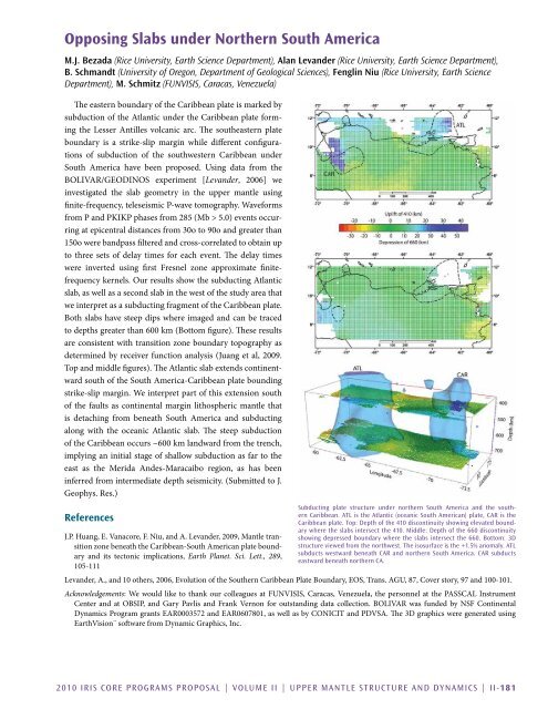
to depths greater than 600 km (Bottom figure). These results<br />
are consistent with transition zone boundary topography as<br />
determined by receiver function analysis (Juang et al, 2009.<br />
Top and middle figures). The Atlantic slab extends continentward<br />
south of the South America-Caribbean plate bounding<br />
strike-slip margin. We interpret part of this extension south<br />
of the faults as continental margin lithospheric mantle that<br />
is detaching from beneath South America and subducting<br />
along with the oceanic Atlantic slab. The steep subduction<br />
of the Caribbean occurs ~600 km landward from the trench,<br />
implying an initial stage of shallow subduction as far to the<br />
east as the Merida Andes-Maracaibo region, as has been<br />
inferred from intermediate depth seismicity. (Submitted to J.<br />
Geophys. Res.)<br />
References<br />
J.P. Huang, E. Vanacore, F. Niu, and A. Levander, 2009, Mantle transition<br />
zone beneath the Caribbean-South American plate boundary<br />
and its tectonic implications, Earth Planet. Sci. Lett., <strong>28</strong>9,<br />
105-111<br />
Subducting plate structure under northern South America and the southern<br />
Caribbean. ATL is the Atlantic (oceanic South American) plate, CAR is the<br />
Caribbean plate. Top: Depth of the 410 discontinuity showing elevated boundary<br />
where the slabs intersect the 410. Middle: Depth of the 660 discontinuity<br />
showing depressed boundary where the slabs intersect the 660. Bottom: 3D<br />
structure viewed from the northwest. The isosurface is the +1.5% anomaly. ATL<br />
subducts westward beneath CAR and northern South America. CAR subducts<br />
eastward beneath northern CA.<br />
Levander, A., and 10 others, 2006, Evolution of the Southern Caribbean Plate Boundary, EOS, Trans. AGU, 87, Cover story, 97 and 100-101.<br />
Acknowledgements: We would like to thank our colleagues at FUNVISIS, Caracas, Venezuela, the personnel at the PASSCAL Instrument<br />
Center and at OBSIP, and Gary Pavlis and Frank Vernon for outstanding data collection. BOLIVAR was funded by NSF Continental<br />
Dynamics Program grants EAR0003572 and EAR0607801, as well as by CONICIT and PDVSA. The 3D graphics were generated using<br />
EarthVision¨ software from Dynamic Graphics, Inc.<br />
2010 <strong>IRIS</strong> Core Programs Proposal | <strong>Volume</strong> <strong>II</strong> | Upper Mantle Structure and Dynamics | <strong>II</strong>-181


