

Download Volume II Accomplisments (28 Mb pdf). - IRIS
Download Volume II Accomplisments (28 Mb pdf). - IRIS
Download Volume II Accomplisments (28 Mb pdf). - IRIS

You also want an ePaper? Increase the reach of your titles
YUMPU automatically turns print PDFs into web optimized ePapers that Google loves.
Colorado Plateau<br />
Survival and Demise of Thick Continental Lithosphere under<br />
Highly Extended Crust<br />
Vera Schulte-Pelkum (University of Colorado at Boulder), Glenn Biasi (University of Nevada, Reno), Anne Sheehan<br />
(University of Colorado at Boulder), Craig Jones (University of Colorado at Boulder)<br />
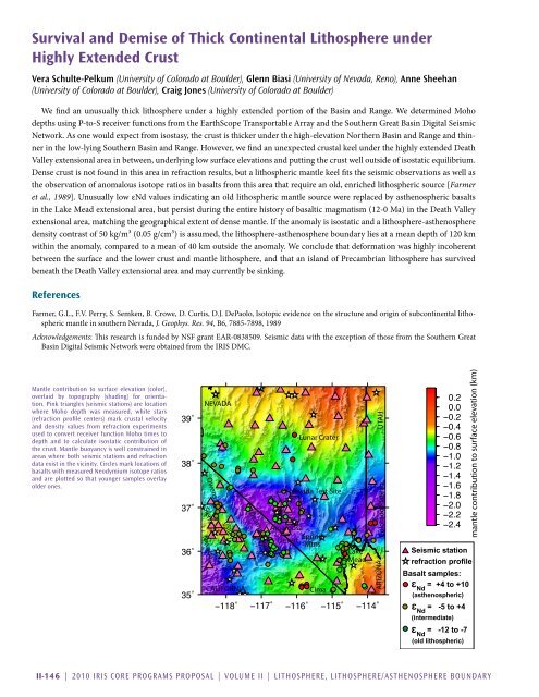
We find an unusually thick lithosphere under a highly extended portion of the Basin and Range. We determined Moho<br />
depths using P-to-S receiver functions from the EarthScope Transportable Array and the Southern Great Basin Digital Seismic<br />
Network. As one would expect from isostasy, the crust is thicker under the high-elevation Northern Basin and Range and thinner<br />
in the low-lying Southern Basin and Range. However, we find an unexpected crustal keel under the highly extended Death<br />
Valley extensional area in between, underlying low surface elevations and putting the crust well outside of isostatic equilibrium.<br />
Dense crust is not found in this area in refraction results, but a lithospheric mantle keel fits the seismic observations as well as<br />
the observation of anomalous isotope ratios in basalts from this area that require an old, enriched lithospheric source [Farmer<br />
et al., 1989]. Unusually low εNd values indicating an old lithospheric mantle source were replaced by asthenospheric basalts<br />
in the Lake Mead extensional area, but persist during the entire history of basaltic magmatism (12-0 Ma) in the Death Valley<br />
extensional area, matching the geographical extent of dense mantle. If the anomaly is isostatic and a lithosphere-asthenosphere<br />
density contrast of 50 kg/m³ (0.05 g/cm³) is assumed, the lithosphere-asthenosphere boundary lies at a mean depth of 120 km<br />
within the anomaly, compared to a mean of 40 km outside the anomaly. We conclude that deformation was highly incoherent<br />
between the surface and the lower crust and mantle lithosphere, and that an island of Precambrian lithosphere has survived<br />
beneath the Death Valley extensional area and may currently be sinking.<br />
References<br />
Farmer, G.L., F.V. Perry, S. Semken, B. Crowe, D. Curtis, D.J. DePaolo, Isotopic evidence on the structure and origin of subcontinental lithospheric<br />
mantle in southern Nevada, J. Geophys. Res. 94, B6, 7885-7898, 1989<br />
Acknowledgements: This research is funded by NSF grant EAR-0838509. Seismic data with the exception of those from the Southern Great<br />
Basin Digital Seismic Network were obtained from the <strong>IRIS</strong> DMC.<br />
Mantle contribution to surface elevation (color),<br />
overlaid by topography (shading) for orientation.<br />
Pink triangles (seismic stations) are location<br />
where Moho depth was measured, white stars<br />
(refraction profile centers) mark crustal velocity<br />
and density values from refraction experiments<br />
used to convert receiver function Moho times to<br />
depth and to calculate isostatic contribution of<br />
the crust. Mantle buoyancy is well constrained in<br />
areas where both seismic stations and refraction<br />
data exist in the vicinity. Circles mark locations of<br />
basalts with measured Neodymium isotope ratios<br />
and are plotted so that younger samples overlay<br />
older ones.<br />
NEVADA<br />
Sierra<br />
Nevada<br />
Owens<br />
Valley<br />
CALIFORNIA<br />
Death Valley<br />
Lunar Crater<br />
Nevada Test Site<br />
Amargosa<br />
Spring<br />
Desert<br />
Mtns<br />
Cima<br />
Lake<br />
Mead<br />
ARIZONA UTAH<br />
Seismic station<br />
refraction profile<br />
Basalt samples:<br />
= +4 to +10<br />
Nd<br />
(asthenospheric)<br />
= -5 to +4<br />
Nd<br />
(intermediate)<br />
= -12 to -7<br />
Nd<br />
(old lithospheric)<br />
mantle contribution to surface elevation (km)<br />
<strong>II</strong>-146 | 2010 <strong>IRIS</strong> Core Programs Proposal | <strong>Volume</strong> <strong>II</strong> | Lithosphere, Lithosphere/Asthenosphere Boundary


