- Page 1 and 2:
volume ii - accomplishments Facilit
- Page 3 and 4:
volume ii - accomplishments Facilit
- Page 5 and 6:
CONTENTS Introduction..............
- Page 7 and 8:
Non-Volcanic Tremor along the Oaxac
- Page 9 and 10:
Detecting the Limit of Slab Break-o
- Page 11:
Lower Mantle, Core-Mantle Boundary
- Page 14 and 15:
• Non-Earthquake Seismic Sources
- Page 16 and 17:
acoustics community by permitting a
- Page 18 and 19:
Near-Surface Environments - Hazards
- Page 20 and 21:
Why Do Faults Slip? Emily Brodsky (
- Page 22 and 23:
Another probe of fault evolution is
- Page 24 and 25:
to provide a best match with the Gl
- Page 26 and 27:
tectonic disruption and mass accumu
- Page 28 and 29:
W3 ∆ 5 . A number of intriguing r
- Page 30 and 31:
thermal and compositional effects r
- Page 33 and 34:
Towards a Global School Seismic Net
- Page 35 and 36:
On-Line Seismology Curriculum for U
- Page 37 and 38:
Teachers on the Leading Edge: Earth
- Page 39 and 40:
USArray Education and Outreach in S
- Page 41 and 42:
From an IRIS Lecture Tour to a Gene
- Page 43 and 44:
Explorer Series Robert Bartolotta (
- Page 45 and 46:
Workshop “Earth System Science fo
- Page 47 and 48:
The IRIS Internship Cycle: From Int
- Page 49 and 50:
Community-Outreach Efforts in Data
- Page 51 and 52:
Site Reconnaissance for Earthscope
- Page 53 and 54:
jAmaseis: Seismology Software Meeti
- Page 55 and 56:
Near Real-Time Simulations of Globa
- Page 57 and 58:
FuncLab: A MATLAB Interactive Toolb
- Page 59 and 60:
Five Years of Distributing the Seis
- Page 61 and 62:
IRIS DMS Data Products, Beyond Raw
- Page 63 and 64:
Local Earthquakes in the Dallas-Ft.
- Page 65 and 66:
Epicentral Location Based on Raylei
- Page 67 and 68:
Analysis of Spatial and Temporal Se
- Page 69 and 70:
Exceptional Ground Motions from the
- Page 71 and 72:
The 2010 Mw7.2 El Mayor-Cucapah Ear
- Page 73 and 74:
Effects of Kinematic Constraints on
- Page 75 and 76:
Imaging of the Source Properties of
- Page 77 and 78:
Teleseismic Inversion for Rupture P
- Page 79 and 80:
The Global Aftershocks of the 2004
- Page 81 and 82:
The 17 July 2006 Java Tsunami Earth
- Page 83 and 84:
Seismic Cycles on Oceanic Transform
- Page 85 and 86:
Migration of Early Aftershocks Foll
- Page 87 and 88:
Apparent Stress Variations at the O
- Page 89 and 90:
Automated Identification of Telesei
- Page 91 and 92:
Evaluating Ground Motion Prediction
- Page 93 and 94:
Tremor Monitoring Aaron Wech (Unive
- Page 95 and 96:
Slow Slip and Tremor in the Norther
- Page 97 and 98:
0 0.5 1 1.5 2 2.5 3 0 0.5 1 1.5 2 2
- Page 99 and 100:
Intimate Details of Tremor Observed
- Page 101 and 102:
Global Search of Triggered Tremor a
- Page 103 and 104:
Slab Morphology in the Cascadia For
- Page 105 and 106:
Source Analysis of the Memorial Day
- Page 107 and 108:
Iceberg Tremor and Ocean Signals Ob
- Page 109 and 110:
Elucidating the Stick-Slip Nature o
- Page 111 and 112:
Probing the Atmosphere and Atmosphe
- Page 113 and 114:
Volcanic Plume Height Measured by S
- Page 115 and 116:
Eruption Dynamics at Mount St. Hele
- Page 117 and 118:
A Search for the Lunar Core Using A
- Page 119 and 120:
Seismic Imaging of the Mt. Rose Fau
- Page 121 and 122:
Structure of the California Coast R
- Page 123 and 124:
Temporal Variations in Crustal Scat
- Page 125 and 126:
High-Resolution Locations of Trigge
- Page 127 and 128:
Adjoint Tomography of the Southern
- Page 129 and 130:
Crustal Structure of the High Lava
- Page 131 and 132:
Controlled Source Seismic Experimen
- Page 133 and 134: Structural Interpretations Based on
- Page 135 and 136: Optimized Velocities and Prestack D
- Page 137 and 138: 40 Crustal Structure beneath the Hi
- Page 139 and 140: Controlled-Source Seismic Investiga
- Page 141 and 142: Northward Thinning of Tibetan Crust
- Page 143 and 144: An Integrated Analysis of an Ancien
- Page 145 and 146: Crustal Velocity Structure of Turke
- Page 147 and 148: Ambient Noise Tomography of the Pam
- Page 149 and 150: Ambient Noise Monitoring of Seismic
- Page 151 and 152: Mushy Magma beneath Yellowstone Ris
- Page 153 and 154: Imaging the Seattle Basin to Improv
- Page 155 and 156: Developing a Database of ENA Ground
- Page 157 and 158: Lithospheric Layering in the North
- Page 159 and 160: eflective zones on depthmigrated se
- Page 161 and 162: FischerFig05.pdf 1 2/8/10 12:31 PM
- Page 163 and 164: S-Velocity Structure of Cratons, fr
- Page 165 and 166: Seismic Structure of the Crust and
- Page 167 and 168: Subducted Oceanic Asthenosphere and
- Page 169 and 170: Detecting the Limit of Slab Break-o
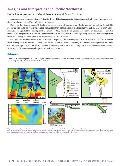
- Page 171 and 172: Pn Tomography of the Western United
- Page 173 and 174: 3-D Isotropic Shear Velocity Model
- Page 175 and 176: Seismic Anisotropy Associated with
- Page 177 and 178: Anisotropy in the Great Basin from
- Page 179 and 180: Source-Side Shear Wave Splitting an
- Page 181 and 182: S-Velocity Structure of the Upper M
- Page 183: Velocity Structure of the Western U
- Page 187 and 188: Imaging the Mantle Wedge in the Cen
- Page 189 and 190: A Slab Remnant beneath the Gulf of
- Page 191 and 192: Imaging the Southern Alaska Subduct
- Page 193 and 194: Opposing Slabs under Northern South
- Page 195 and 196: Effect of Prior Petrological Constr
- Page 197 and 198: Global Azimuthal Seismic Anisotropy
- Page 199 and 200: The Stratification of Seismic Azimu
- Page 201 and 202: Upper Mantle Anisotropy beneath the
- Page 203 and 204: The Teleseismic Signature of Fossil
- Page 205 and 206: Seismic Anisotropy under Central Al
- Page 207 and 208: Stress-Induced Upper Crustal Anisot
- Page 209 and 210: Tau-p Depropagation of Five Regiona
- Page 211 and 212: Mapping the Upper Mantle with the S
- Page 213 and 214: Upper Mantle Structure of Southern
- Page 215 and 216: The Africa-Europe Plate Boundary in
- Page 217 and 218: The Isabella Anomaly Imaged by Eart
- Page 219 and 220: Tomographic Image of the Crust and
- Page 221 and 222: Small-Scale Mantle Heterogeneity an
- Page 223 and 224: Mantle Heterogeneity West and East
- Page 225 and 226: New Geophysical Insight into the Or
- Page 227 and 228: The Plume-slab Interaction beneath
- Page 229 and 230: Imaging the Shear Wave Velocity "Pl
- Page 231 and 232: Slab Fragmentation and Edge Flow: I
- Page 233 and 234: Mantle Shear-Wave Velocity Structur
- Page 235 and 236:
Discordant Contrasts of P- and S-Wa
- Page 237 and 238:
Upper Mantle Discontinuity Topograp
- Page 239 and 240:
Edge-Driven Convection beneath the
- Page 241 and 242:
Imaging Attenuation in the Upper Ma
- Page 243 and 244:
Three-Dimensional Electrical Conduc
- Page 245 and 246:
Core-Mantle Boundary Heat Flow Thor
- Page 247 and 248:
Constraints on Lowermost Mantle Ani
- Page 249 and 250:
Localized Double-Array Stacking Ana
- Page 251 and 252:
Waveform Modeling of D" Discontinui
- Page 253 and 254:
Absence of Ultra-Low Velocity Zones
- Page 255 and 256:
Moving Seismic Tomography Beyond Fa
- Page 257 and 258:
A Three-Dimensional Radially Anisot
- Page 259 and 260:
The Importance of Crustal Correctio
- Page 261 and 262:
Slabs Do Not Go Gentle Karin Sigloc
- Page 263 and 264:
Localized Temporal Change of the Ea
- Page 265 and 266:
Core Structure Reexamined Using New
- Page 267 and 268:
Large Variations in Travel Times of
- Page 269 and 270:
Observations of Antipodal PKIIKP Wa
- Page 271 and 272:
Regional Variation of Inner Core An
- Page 273:
Wide-Scale Detection of Earthquake