

Download Volume II Accomplisments (28 Mb pdf). - IRIS
Download Volume II Accomplisments (28 Mb pdf). - IRIS
Download Volume II Accomplisments (28 Mb pdf). - IRIS

Create successful ePaper yourself
Turn your PDF publications into a flip-book with our unique Google optimized e-Paper software.
Imaging Lithospheric Foundering beneath the Central Sierra<br />
Nevada with Receiver Functions, Teleseismic Surface Waves, and<br />
Earthquake Locations<br />
Andy Frassetto (University of Copenhagen), Hersh Gilbert (Purdue University), Owen Hurd (Stanford University), George<br />
Zandt (University of Arizona), Thomas J. Owens (University of South Carolina), Craig H. Jones (University of Colorado)<br />
The southern Sierra Nevada represents a fundamental example of a Cordilleran batholith which has recently lost its eclogitized,<br />
mafic-ultramafic lower crust and lithospheric mantle. From May 2005 through September 2007, the Sierra Nevada<br />
EarthScope Project (SNEP) targeted the central and northern Sierra Nevada with an array of broadband seismometers to characterize<br />
how lithospheric foundering relates to the Isabella and Redding deep seismic anomalies, the modern relief of the Sierra,<br />
and ongoing deformation and volcanism in eastern California. Selected key findings from our current study show evidence for<br />
ongoing foundering beneath the west-central Sierra Nevada, just southwest of Yosemite National Park.<br />
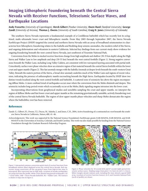
Conversions from the Moho in stacked receiver functions change from high amplitude and shallow (30-35 km depth) along the High<br />
Sierra and Walker Lane to low amplitude and deep (50-55 km) beneath the west-central foothills (Figure 1). Strong negative conversions<br />
beneath the Walker Lane, including Long Valley Caldera, are consistent with low wavespeed layering associated with partial melt.<br />
Coincidently, surface wave phase velocities show an extensive region of fast material beneath the central Sierra foothills within the lower<br />
crust and upper mantle (Figure 2). This fast anomaly merges with the Isabella Anomaly at deeper levels beneath the south-western Great<br />
Valley. Beneath the eastern portion of the Sierra, a broad slow anomaly underlies much of the Walker Lane and regions of recent volcanism,<br />
indicating the presence of asthenospheric mantle encroaching beneath the High Sierra. Earthquakes located by SNEP show two<br />
distinct trends localized along the west-central foothills and batholith. A scattered zone of seismicity lies above the region encompassing<br />
diffuse Moho. A more confined trend of earthquakes occurs near where the conversions from the Moho diminish and deepen. This<br />
seismicity includes long-period events which occasionally occur at the Moho, likely signaling magma intrusion into the lower crust.<br />
Incorporating observations from geophysical studies and xenoliths sampling the crust and upper mantle, we interpret the<br />
region of diffuse Moho and fast lower crust and upper mantle as the remaining gravitationally unstable, actively foundering root<br />
of the central Sierra Nevada batholith. The region of slow upper mantle phase velocities and sharp Moho demarcates the region<br />
where the batholithic root has been removed.<br />
References<br />
Zandt, G., Gilbert, H., Owens, T.J., Ducea, M., Saleeby, J., and Jones, C.H., 2004, Active foundering of a continental arc root beneath the southern<br />
Sierra Nevada in California, Nature, 431, 41–46.<br />
Acknowledgements: This work was supported by the National Science Foundation’s EarthScope grants EAR-0454554, EAR-0454524, and EAR-<br />
0454535 to the Universities of Arizona, Colorado, and South Carolina. This work was also made possible by funding from the National Science<br />
Foundation through the Graduate Research Fellowship Program.<br />
Figure 1: Interpreted common-conversion-point stack of receiver functions from<br />
broadband stations (blue) deployed across the central Sierra Nevada. Red represents<br />
strong conversions off the up-going P-wave from high-to-low steps in<br />
wavespeed; blue represents low-to-high steps. Locations of nearby earthquakes<br />
are projected onto the profile. White circles denote long period earthquakes. GV<br />
= Great Valley, SNB = Sierra Nevada batholith, WL = Walker Lane. The transect<br />
is shown in map view in Figure 2.<br />
Figure 2: Phase velocities for 30 second (left) and 67 second (right) period teleseismic<br />
surface waves. Shading ranges from pink (>4.2 km/s) to red (


