Successful transport decision-making - Osmose
Successful transport decision-making - Osmose
Successful transport decision-making - Osmose

You also want an ePaper? Increase the reach of your titles
YUMPU automatically turns print PDFs into web optimized ePapers that Google loves.
Urban Transport Plan in Ile-de-France<br />
Vol 1 - <br />
Vol 2 - <br />
Next<br />
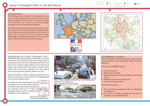
Ile-de-France<br />
The Ile-de-France covers 12,000km² of the central-northern part of<br />
France. It contains the heavily built-up area of Paris, but 49% of the<br />
region is farmland and 23% forest. It has 11m inhabitants - including<br />
2.1m in Paris proper - and 4.7m jobs. It is one of the world's largest<br />
urban areas, and its fourth most productive metropolis.<br />
Travel needs have grown steadily over the past 20 years. More people<br />
are travelling between Paris and its suburbs, and between suburbs.<br />
They are doing so less and less for work and more and more for<br />
leisure. Cars now account for 45% of the region's journeys.<br />
Unsurprisingly, the consequences have been a rise in noise and air<br />
pollution; road accidents and urban sprawl are also issues.<br />
Developing the Urban Transport Plan<br />
GUIDEMAPS looked at the development and introduction of the Urban<br />
Transport Plan for the Ile-de-France. Such Urban Transport Plans are<br />
compulsory for towns of more than 100,000 people within France. Their<br />
basic aims are to achieve a balance between cars and other forms of<br />
<strong>transport</strong>, and to place <strong>transport</strong> issues under the control of a single<br />
authority. They are drawn up in consultation with a broad range of<br />
groups, including community authorities, operators, and users.<br />
Normally, the authority in charge of organising <strong>transport</strong> controls the<br />
plan, but in Ile-de-France it is run by the state. This is largely because<br />
of Paris' role as the capital of France.<br />
The Ile-de-France plan includes measures aimed at<br />
encouraging the use of public <strong>transport</strong>, improving<br />
the planning of major road networks, encouraging a<br />
more sustainable modal split for freight, and<br />
managing its operation in towns. It is consistent with<br />
the Regional Land Use Master Plan.<br />
The plan document, available at<br />
http://www.pduif.org/lepduif/plan.php<br />
Above: Traffic congestion in Ile-de-France - one of the problems<br />
addressed by the Master Plan.<br />
Below: Seeking multi-modal solutions.<br />
GUIDEMAPS interests<br />
Planners are using new consultation and <strong>decision</strong>-<strong>making</strong> procedures<br />
at the development and the implementation stages of the Ile-de-<br />
France plan.<br />
In Ile-de-France, GUIDEMAPS explores:<br />
<br />
<br />
<br />
<br />
<br />
How the plan evolved;<br />
What hurdles it encountered;<br />
What measures were put forward and applied to overcome these<br />
hurdles;<br />
What factors were crucial in its success; and<br />
The <strong>decision</strong>-<strong>making</strong> procedures.<br />
Techniques reviewed include:<br />
<br />
<br />
The use of task forces in drawing up the plan - an original feature<br />
of the project; and<br />
The numerous committees, especially road, hub and local<br />
committees, set up to implement the plan.<br />
14