Successful transport decision-making - Osmose
Successful transport decision-making - Osmose
Successful transport decision-making - Osmose

Create successful ePaper yourself
Turn your PDF publications into a flip-book with our unique Google optimized e-Paper software.
Cologne: Moderated Internet forum for the<br />
redesign of an inner city ring-road<br />
Vol 1 - <br />
Vol 2 - <br />
Next<br />
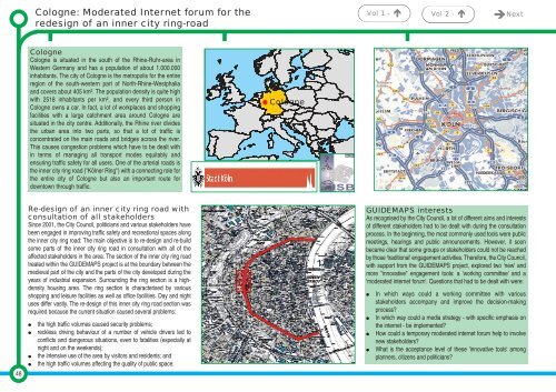
Cologne<br />
Cologne is situated in the south of the Rhine-Ruhr-area in<br />
Western Germany and has a population of about 1.000.000<br />
inhabitants. The city of Cologne is the metropolis for the entire<br />
region of the south-western part of North-Rhine-Westphalia<br />
and covers about 405 km². The population density is quite high<br />
with 2518 inhabitants per km², and every third person in<br />
Cologne owns a car. In fact, a lot of workplaces and shopping<br />
facilities with a large catchment area around Cologne are<br />
situated in the city centre. Additionally, the Rhine river divides<br />
the urban area into two parts, so that a lot of traffic is<br />
concentrated on the main roads and bridges across the river.<br />
This causes congestion problems which have to be dealt with<br />
in terms of managing all <strong>transport</strong> modes equitably and<br />
ensuring traffic safety for all users. One of the arterial roads is<br />
the inner city ring road ("Kölner Ring") with a connecting role for<br />
the entire city of Cologne but also an important route for<br />
downtown through traffic.<br />
Cologne<br />
48<br />
Re-design of an inner city ring road with<br />
consultation of all stakeholders<br />
Since 2001, the City Council, politicians and various stakeholders have<br />
been engaged in improving traffic safety and recreational spaces along<br />
the inner city ring road: The main objective is to re-design and re-build<br />
some parts of the inner city ring road in consultation with all of the<br />
affected stakeholders in the area. The section of the inner city ring road<br />
treated within the GUIDEMAPS project is at the boundary between the<br />
medieval part of the city and the parts of the city developed during the<br />
years of industrial expansion. Surrounding the ring section is a highdensity<br />
housing area. The ring section is characterised by various<br />
shopping and leisure facilities as well as office facilities. Day and night<br />
uses differ vastly. The re-design of this inner city ring road section was<br />
required because the current situation caused several problems:<br />
<br />
<br />
<br />
<br />
the high traffic volumes caused security problems;<br />
reckless driving behaviour of a number of vehicle drivers led to<br />
conflicts and dangerous situations, even to fatalities (especially at<br />
night and on the weekends);<br />
the intensive use of the area by visitors and residents; and<br />
the high traffic volumes affecting the quality of public space.<br />
GUIDEMAPS interests<br />
As recognised by the City Council, a lot of different aims and interests<br />
of different stakeholders had to be dealt with during the consultation<br />
process. In the beginning, the most commonly used tools were public<br />
meetings, hearings and public announcements. However, it soon<br />
became clear that some groups or stakeholders could not be reached<br />
by those 'traditional' engagement activities. Therefore, the City Council,<br />
with support from the GUIDEMAPS project, explored two 'new' and<br />
more "innovative" engagement tools: a 'working committee' and a<br />
'moderated internet forum'. Questions that had to be dealt with were:<br />
<br />
<br />
<br />
<br />
In which ways could a working committee with various<br />
stakeholders accompany and improve the <strong>decision</strong>-<strong>making</strong><br />
process?<br />
In which way could a media strategy - with specific emphasis on<br />
the internet - be implemented?<br />
How could a temporary moderated internet forum help to involve<br />
new stakeholders?<br />
What is the acceptance level of these 'innovative tools' among<br />
planners, citizens and politicians?