

State of Alabama FINAL Coastal Impact Assistance Program (CIAP ...
State of Alabama FINAL Coastal Impact Assistance Program (CIAP ...
State of Alabama FINAL Coastal Impact Assistance Program (CIAP ...

Create successful ePaper yourself
Turn your PDF publications into a flip-book with our unique Google optimized e-Paper software.
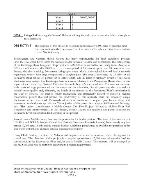
AL2-10<br />
Year 1 $ 10,000,000.00<br />
Year 2 $<br />
-<br />
Year 3 $<br />
-<br />
Year 4 $<br />
-<br />
GOAL: Using <strong>CIAP</strong> funding, the <strong>State</strong> <strong>of</strong> <strong>Alabama</strong> will acquire and conserve sensitive habitat throughout<br />
the coastal area.<br />
OBJECTIVE: The objective <strong>of</strong> this project is to acquire approximately 5,000 acres <strong>of</strong> sensitive land<br />
for conservation in the Escatawpa River Corridor and/or other sensitve habitats within<br />
coastal Mobile County.<br />
Southwestern and western Mobile County has many opportunities for land acquisition projects.<br />
First, the Escatawpa River forms the western border between <strong>Alabama</strong> and Mississippi. The total acreage<br />
<strong>of</strong> the Escatawpa River Longleaf Hills project area is 20,000 acres, owned by one family trust. Analysis <strong>of</strong><br />
GIS data indicates that this 20,000 acre tract is comprised <strong>of</strong> 75 percent upland and 20 percent wetland<br />
forests, with the remaining five percent being open water. Much <strong>of</strong> the upland forested land is naturally<br />
regenerated timber, with large components <strong>of</strong> longleaf pine. The tract is intersected by 25 miles <strong>of</strong> the<br />
Escatawpa River (about 30 percent <strong>of</strong> its entire length) and 29 miles <strong>of</strong> tributary stream <strong>of</strong> this classic<br />
blackwater river system. The Escatawpa River is a major tributary to the Pasagagoula River, which in turn<br />
is part <strong>of</strong> the Grand Bay National Estuarine Research Reserve’s watershed area. The tract encompasses<br />
both banks <strong>of</strong> large portions <strong>of</strong> the Escatawpa and its tributaries, directly protecting the river and the<br />
system’s water quality, and, ultimately, the health <strong>of</strong> the estuaries at the Pascagoula River’s termination in<br />
the Gulf <strong>of</strong> Mexico. The tract is readily manageable and strategically located to initiate a regional<br />
conservation project that will protect the biodiversity <strong>of</strong> this relatively small but extremely unique<br />
blackwater stream watershed. Thousands <strong>of</strong> acres <strong>of</strong> southeastern longleaf pine habitat along with<br />
bottomland wetland make up this area. The objective <strong>of</strong> this project is to acquire 5,000 acres <strong>of</strong> this target<br />
tract. This project complements a Mobile County Tier Two Project: ‘Escatawpa Hollow River Park<br />
Acquisition and Improvements’. In this project, Mobile County will acquire a key parcel to access the<br />
Escatawpa River conservation land targeting in this project.<br />
Second, coastal Mobile County has many opportunities for land acquisition. The <strong>State</strong> <strong>of</strong> <strong>Alabama</strong> and the<br />
U.S. Fish and Wildlife Service (Grand Bay National Estuarine Research Reserve) have already acquired<br />
almost 10,000 acres <strong>of</strong> this unique wetland habitat. Additional parcels may be available for purchase in this<br />
area which will link and enhance existing conservation property.<br />
Using <strong>CIAP</strong> funding, the <strong>State</strong> <strong>of</strong> <strong>Alabama</strong> will acquire and conserve sensitive habitat throughout the<br />
coastal area. The objective <strong>of</strong> this project is to acquire approximately 5,000 acres <strong>of</strong> sensitive land for<br />
conservation in the Escawtawpa River and/or coastal Mobile County. The property will be managed by<br />
the SLD and deed will be restricted according to program requirements.<br />
<strong>State</strong> <strong>of</strong> <strong>Alabama</strong> Final <strong>Coastal</strong> <strong>Impact</strong> <strong>Assistance</strong> <strong>Program</strong> Plan<br />
<strong>State</strong> <strong>of</strong> <strong>Alabama</strong> Tier Two Project Descriptions<br />
- 238 -


