- Page 1:
State of Alabama FINAL Coastal Impa
- Page 5:
Table of Contents List of Acronyms.
- Page 9 and 10:
List of Acronyms ACAMP.............
- Page 11 and 12:
1. Introduction The Coastal Impact
- Page 13 and 14:
2. Designated State Agency The Ener
- Page 15 and 16:
3. Designated Contact for Coastal P
- Page 17 and 18:
4. Governor’s Certification of Pu
- Page 19 and 20:
5. Coordination with Other Federal
- Page 21 and 22:
6. Plan Implementation Program Goa
- Page 23 and 24:
involvement previously in a similar
- Page 25 and 26:
o April 24, 2007, the Mobile County
- Page 27 and 28:
supports funding for Dauphin Island
- Page 29 and 30:
o June 18, 2007 the CIAP Planning t
- Page 31 and 32:
included in the Mobile County Coast
- Page 33 and 34:
in the CIAP Plan which complement e
- Page 35 and 36:
Total Land Acquisition Research Ene
- Page 37 and 38:
7. Proposed Project Lists State of
- Page 39 and 40:
a. State of Alabama Tier 1 Projects
- Page 41 and 42:
(Table 2 of 2) Project Number Proje
- Page 43 and 44:
. Baldwin County Tier One Projects
- Page 45 and 46:
c. Mobile County Tier One Projects
- Page 47 and 48:
d. State of Alabama Tier Two Projec
- Page 49 and 50:
e. Baldwin County Tier Two Projects
- Page 51 and 52:
f. Mobile County Tier Two Projects
- Page 53 and 54:
8. Proposed Tier One Project Descri
- Page 55 and 56:
a. State of Alabama Tier One Projec
- Page 57 and 58:
Table 2 of 2 Project Number Project
- Page 59 and 60:
STATE OF ALABAMA COASTAL IMPACT ASS
- Page 61 and 62:
approval. The property will be mana
- Page 63 and 64:
STATE OF ALABAMA COASTAL IMPACT ASS
- Page 65 and 66:
STATE OF ALABAMA COASTAL IMPACT ASS
- Page 67 and 68:
emaining locations will be determin
- Page 69 and 70:
STATE OF ALABAMA COASTAL IMPACT ASS
- Page 71 and 72:
Alabama will partner with capital i
- Page 73 and 74:
STATE OF ALABAMA COASTAL IMPACT ASS
- Page 75 and 76:
planning process could include Chic
- Page 77 and 78:
STATE OF ALABAMA COASTAL IMPACT ASS
- Page 79 and 80:
o Justification: This project meets
- Page 81 and 82:
STATE OF ALABAMA COASTAL IMPACT ASS
- Page 83 and 84:
SLD conservation staff will identif
- Page 85 and 86:
STATE OF ALABAMA COASTAL IMPACT ASS
- Page 87 and 88:
AUTHORIZED USE o This project meets
- Page 89 and 90:
STATE OF ALABAMA COASTAL IMPACT ASS
- Page 91 and 92:
large commercial shrimp boats moore
- Page 93 and 94:
STATE OF ALABAMA COASTAL IMPACT ASS
- Page 95 and 96:
STATE OF ALABAMA COASTAL IMPACT ASS
- Page 97 and 98:
STATE OF ALABAMA COASTAL IMPACT ASS
- Page 99 and 100:
These state-owned facilities highli
- Page 101 and 102:
STATE OF ALABAMA COASTAL IMPACT ASS
- Page 103 and 104:
AUTHORIZED USES o This project meet
- Page 105 and 106:
STATE OF ALABAMA COASTAL IMPACT ASS
- Page 107 and 108:
project and construct it utilizing
- Page 109 and 110:
STATE OF ALABAMA COASTAL IMPACT ASS
- Page 111 and 112:
STATE OF ALABAMA COASTAL IMPACT ASS
- Page 113 and 114:
o This project meets the criteria s
- Page 115 and 116:
STATE OF ALABAMA COASTAL IMPACT ASS
- Page 117 and 118:
o Justification: This project meets
- Page 119 and 120:
STATE OF ALABAMA COASTAL IMPACT ASS
- Page 121 and 122:
Grant support, the AABC has begun r
- Page 123 and 124:
Fish Species Common Name Basin/Syst
- Page 125 and 126:
STATE OF ALABAMA COASTAL IMPACT ASS
- Page 127 and 128:
First, MRD proposes to use CIAP fun
- Page 129 and 130:
STATE OF ALABAMA COASTAL IMPACT ASS
- Page 131 and 132:
In 2006, MRD was able to partially
- Page 133 and 134:
STATE OF ALABAMA COASTAL IMPACT ASS
- Page 135 and 136:
58.47” W), and Mobile County will
- Page 137 and 138:
STATE OF ALABAMA COASTAL IMPACT ASS
- Page 139 and 140:
o Justification: This project meets
- Page 141 and 142:
STATE OF ALABAMA COASTAL IMPACT ASS
- Page 143 and 144:
AUTHORIZED USES o This project meet
- Page 145 and 146:
STATE OF ALABAMA COASTAL IMPACT ASS
- Page 147 and 148:
This site will provide public acces
- Page 149 and 150:
. Baldwin County Tier One Project D
- Page 151 and 152:
STATE OF ALABAMA COASTAL IMPACT ASS
- Page 153 and 154:
waterways because the roads are not
- Page 155 and 156:
STATE OF ALABAMA COASTAL IMPACT ASS
- Page 157 and 158:
All property purchased using CIAP f
- Page 159 and 160:
STATE OF ALABAMA COASTAL IMPACT ASS
- Page 161 and 162:
STATE OF ALABAMA COASTAL IMPACT ASS
- Page 163 and 164:
draft that pulls the landfill gas f
- Page 165 and 166:
STATE OF ALABAMA COASTAL IMPACT ASS
- Page 167 and 168:
Many of the current environmental i
- Page 169 and 170:
STATE OF ALABAMA COASTAL IMPACT ASS
- Page 171 and 172:
GRASSES/ WEEDS • Cogongrass: Colo
- Page 173 and 174:
STATE OF ALABAMA COASTAL IMPACT ASS
- Page 175 and 176:
planting, sand fencing will be inst
- Page 177 and 178:
STATE OF ALABAMA COASTAL IMPACT ASS
- Page 179 and 180:
Despite the variety of important be
- Page 181 and 182:
STATE OF ALABAMA COASTAL IMPACT ASS
- Page 183 and 184:
County will each submit a separate
- Page 185 and 186:
STATE OF ALABAMA COASTAL IMPACT ASS
- Page 187 and 188:
An additional aspect of this initia
- Page 189 and 190:
STATE OF ALABAMA COASTAL IMPACT ASS
- Page 191 and 192:
AUTHORIZED USES o This project meet
- Page 193 and 194:
c. Mobile County Tier One Project D
- Page 195 and 196:
STATE OF ALABAMA COASTAL IMPACT ASS
- Page 197 and 198:
STATE OF ALABAMA COASTAL IMPACT ASS
- Page 199 and 200:
public on the ecological importance
- Page 201 and 202:
STATE OF ALABAMA COASTAL IMPACT ASS
- Page 203 and 204:
o Cost Sharing: Cost sharing is not
- Page 205 and 206:
STATE OF ALABAMA COASTAL IMPACT ASS
- Page 207 and 208:
STATE OF ALABAMA COASTAL IMPACT ASS
- Page 209 and 210:
STATE OF ALABAMA COASTAL IMPACT ASS
- Page 211 and 212:
throughout the County. The event wi
- Page 213 and 214:
STATE OF ALABAMA COASTAL IMPACT ASS
- Page 215 and 216:
AUTHORIZED USES o This project meet
- Page 217 and 218:
STATE OF ALABAMA COASTAL IMPACT ASS
- Page 219 and 220:
STATE OF ALABAMA COASTAL IMPACT ASS
- Page 221 and 222:
submit a separate grant application
- Page 223 and 224:
STATE OF ALABAMA COASTAL IMPACT ASS
- Page 225 and 226:
area’s dependence on septic syste
- Page 227 and 228:
STATE OF ALABAMA COASTAL IMPACT ASS
- Page 229 and 230:
o Benefit to the Natural Coastal En
- Page 231 and 232:
STATE OF ALABAMA COASTAL IMPACT ASS
- Page 233 and 234:
conditions. Coordinated and compreh
- Page 235 and 236: STATE OF ALABAMA COASTAL IMPACT ASS
- Page 237 and 238: STATE OF ALABAMA COASTAL IMPACT ASS
- Page 239 and 240: development. Also, waterfront sites
- Page 241 and 242: STATE OF ALABAMA COASTAL IMPACT ASS
- Page 243 and 244: o Cost Sharing: Cost sharing is not
- Page 245 and 246: 9. Proposed Tier Two Project Descri
- Page 247 and 248: a. State of Alabama Tier Two Projec
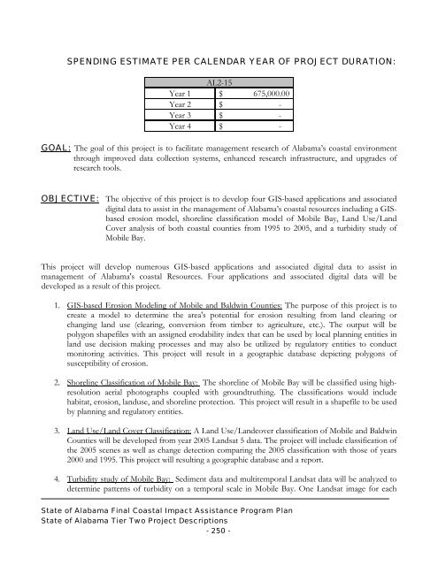
- Page 249 and 250: STATE OF ALABAMA COASTAL IMPACT ASS
- Page 251 and 252: AUTHORIZED USES o This project meet
- Page 253 and 254: STATE OF ALABAMA COASTAL IMPACT ASS
- Page 255 and 256: STATE OF ALABAMA COASTAL IMPACT ASS
- Page 257 and 258: AUTHORIZED USES o This project meet
- Page 259 and 260: STATE OF ALABAMA COASTAL IMPACT ASS
- Page 261 and 262: STATE OF ALABAMA COASTAL IMPACT ASS
- Page 263 and 264: STATE OF ALABAMA COASTAL IMPACT ASS
- Page 265 and 266: STATE OF ALABAMA COASTAL IMPACT ASS
- Page 267 and 268: STATE OF ALABAMA COASTAL IMPACT ASS
- Page 269 and 270: AUTHORIZED USES o This project meet
- Page 271 and 272: STATE OF ALABAMA COASTAL IMPACT ASS
- Page 273 and 274: STATE OF ALABAMA COASTAL IMPACT ASS
- Page 275 and 276: AUTHORIZED USES o This project meet
- Page 277 and 278: STATE OF ALABAMA COASTAL IMPACT ASS
- Page 279 and 280: STATE OF ALABAMA COASTAL IMPACT ASS
- Page 281 and 282: STATE OF ALABAMA COASTAL IMPACT ASS
- Page 283 and 284: STATE OF ALABAMA COASTAL IMPACT ASS
- Page 285: STATE OF ALABAMA COASTAL IMPACT ASS
- Page 289 and 290: . Baldwin County Tier Two Project D
- Page 291 and 292: STATE OF ALABAMA COASTAL IMPACT ASS
- Page 293 and 294: include site conditions such as top
- Page 295 and 296: STATE OF ALABAMA COASTAL IMPACT ASS
- Page 297 and 298: The existing building includes a me
- Page 299 and 300: STATE OF ALABAMA COASTAL IMPACT ASS
- Page 301 and 302: o Justification: This project is co
- Page 303 and 304: STATE OF ALABAMA COASTAL IMPACT ASS
- Page 305 and 306: against saltwater intrusion, which
- Page 307 and 308: c. Mobile County Tier Two Project D
- Page 309 and 310: STATE OF ALABAMA COASTAL IMPACT ASS
- Page 311 and 312: STATE OF ALABAMA COASTAL IMPACT ASS
- Page 313 and 314: Locally heavy rainfall and close pr
- Page 315 and 316: STATE OF ALABAMA COASTAL IMPACT ASS
- Page 317 and 318: o Partnering: Project partners incl
- Page 319 and 320: STATE OF ALABAMA COASTAL IMPACT ASS
- Page 321 and 322: o Benefit to the Natural Coastal En
- Page 323 and 324: STATE OF ALABAMA COASTAL IMPACT ASS
- Page 325 and 326: o Benefit to the Natural Coastal En
- Page 327 and 328: STATE OF ALABAMA COASTAL IMPACT ASS
- Page 329 and 330: STATE OF ALABAMA COASTAL IMPACT ASS
- Page 331 and 332: o Justification: Opportunities for
- Page 333 and 334: STATE OF ALABAMA COASTAL IMPACT ASS
- Page 335 and 336: STATE OF ALABAMA COASTAL IMPACT ASS
- Page 337 and 338:
AUTHORIZED USES o This project meet