

Download PDF - Anchor Environmental
Download PDF - Anchor Environmental
Download PDF - Anchor Environmental

Create successful ePaper yourself
Turn your PDF publications into a flip-book with our unique Google optimized e-Paper software.
The Ramsar site lies entirely within Ngamiland District (Figure 2-1), one of the ten districts of<br />
Botswana, and covers more than half of the area of the district.<br />
While the valuation study considers natural resources throughout the Ramsar site, the primary focus<br />
is on the wetland itself, within the context of the broader study area (the Ramsar Site). Most of the<br />
population that is directly affected by the wetland is within the Ramsar site.<br />
2.2 The physical environment<br />
2.2.1 Topography<br />
The study area is a vast, very gently undulating plain. The only topographic feature which stands out<br />
is the slightly elevated Ghanzi ridge which contains the Tsodilo Hills, in the extreme west of the study<br />
area.<br />
2.2.2 Climate<br />
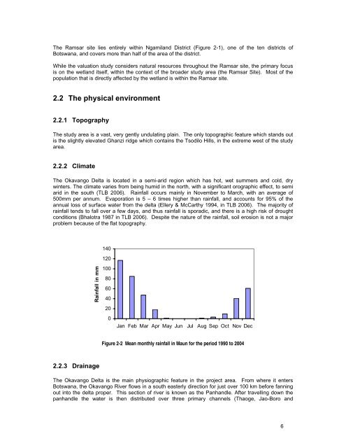
The Okavango Delta is located in a semi-arid region which has hot, wet summers and cold, dry<br />
winters. The climate varies from being humid in the north, with a significant orographic effect, to semi<br />
arid in the south (TLB 2006). Rainfall occurs mainly in November to March, with an average of<br />
500mm per annum. Evaporation is 5 – 6 times higher than rainfall, and accounts for 95% of the<br />
annual loss of surface water from the delta (Ellery & McCarthy 1994, in TLB 2006). The majority of<br />
rainfall tends to fall over a few days, and thus rainfall is sporadic, and there is a high risk of drought<br />
conditions (Bhalotra 1987 in TLB 2006). Despite the nature of the rainfall, soil erosion is not a major<br />
problem because of the flat topography.<br />
140<br />
120<br />
Rainfall in mm<br />
100<br />
80<br />
60<br />
40<br />
20<br />
0<br />
Jan Feb Mar Apr May Jun Jul Aug Sep Oct Nov Dec<br />
Figure 2-2 Mean monthly rainfall in Maun for the period 1990 to 2004<br />
2.2.3 Drainage<br />
The Okavango Delta is the main physiographic feature in the project area. From where it enters<br />
Botswana, the Okavango River flows in a south easterly direction for just over 100 km before fanning<br />
out into the delta proper. This section of river is known as the Panhandle. After travelling down the<br />
panhandle the water is then distributed over three primary channels (Thaoge, Jao-Boro and<br />
6


