COMAND - Mercedes Benz USA
COMAND - Mercedes Benz USA
COMAND - Mercedes Benz USA

You also want an ePaper? Increase the reach of your titles
YUMPU automatically turns print PDFs into web optimized ePapers that Google loves.
3 Main destination<br />
4 Distance/estimated time of arrival/<br />
estimated journey time to the main<br />
destination <<br />
i When calculating the estimated time of<br />
arrival, <strong>COMAND</strong> uses the time set on the<br />
<strong>COMAND</strong> as its basis. For this reason, the<br />
time on <strong>COMAND</strong> must be set correctly<br />
(Y page 41). The calculation of the<br />
estimated time of arrival does not<br />
specifically take into consideration<br />
whether it is summer time or standard time<br />
at the destination. It is not taken into<br />
consideration whether or not the<br />
destination is in a different time zone. The<br />
distance to the destination, the estimated<br />
time of arrival and the estimated remaining<br />
journey time 1, 4 are not displayed until<br />
the route calculation is complete.<br />
X To close the destination information:<br />
Slide omp.<br />
or<br />
X Press the k button.<br />
Traffic Messages<br />
i Optional satellite radio equipment and a<br />
subscription to SIRIUS XM Satellite Radio<br />
service provider are required for the<br />
satellite radio reception referred to here.<br />
You can find more information on SatRadio<br />
in chapter “Satellite Radio” (Y page 127).<br />
Traffic Messages 87<br />
<strong>COMAND</strong> can receive and incorporate traffic<br />
messages via satellite radio into the<br />
navigation system. Traffic report messages<br />
and map symbols can then be viewed in the<br />
<strong>COMAND</strong> display.<br />
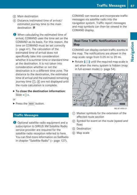
Real-Time Traffic Notifications in the<br />
Map<br />
<strong>COMAND</strong> can display certain traffic events in<br />
the map. The notifications are shown in the<br />
map scale range from 0.05 mi to 20 mi.<br />
X Rotate ymz until the required map scale is<br />
set when the menu system is hidden (map<br />
in full-screen mode) (Y page 54).<br />
1 Marker symbols for the extension of the<br />
affected route section<br />
2 Symbol for event on the route (speed and<br />
flow)<br />
3 Destination<br />
4 Map scale<br />
Z<br />
Navigation