

Archaeoseismology and Palaeoseismology in the Alpine ... - Tierra
Archaeoseismology and Palaeoseismology in the Alpine ... - Tierra
Archaeoseismology and Palaeoseismology in the Alpine ... - Tierra

Create successful ePaper yourself
Turn your PDF publications into a flip-book with our unique Google optimized e-Paper software.
In addition, <strong>the</strong> Database of historical Liquefaction<br />
Occurrences was also released on CD‐ROM where via <strong>the</strong><br />
first page (<strong>in</strong>dex.html), several options are offered (Fig. 1).<br />
In particular, <strong>the</strong> files DALO.mdb (Ms‐Access), <strong>the</strong><br />
DALO.kmz (google earth projection) <strong>and</strong> a guide (Power<br />
Po<strong>in</strong>t file) regard<strong>in</strong>g <strong>the</strong> navigation <strong>in</strong>to <strong>the</strong> database can<br />
be downloaded.<br />
DEVELOPMENT OF THE DATABASE<br />
The Database of historical Liquefaction Occurrences DALO<br />
v1.0 is an open‐access file where <strong>in</strong>formation regard<strong>in</strong>g<br />
liquefaction‐<strong>in</strong>duced ground <strong>and</strong>/or structural<br />
deformations is provided. The first entry <strong>in</strong> <strong>the</strong> dataset is<br />
<strong>in</strong> <strong>the</strong> 16 th century AD, particularly <strong>the</strong> 1509 Instanbul<br />
event, while <strong>the</strong> cut‐off data for this project is provided<br />
by <strong>the</strong> earthquake‐<strong>in</strong>duced liquefaction of June 8th, 2009<br />
<strong>in</strong> NW Peloponnesus, Greece. However, it should be<br />
mentioned that <strong>the</strong> oldest events, which were <strong>in</strong>cluded <strong>in</strong><br />
<strong>the</strong> seismic catalogues <strong>and</strong> correlated to liquefaction‐<br />
<strong>in</strong>duced failures are <strong>the</strong> 373 B.C. <strong>and</strong> 478 A.C events <strong>in</strong><br />
Eliki <strong>and</strong> Sistos areas, respectively.<br />
The majority of collected data are correlated to events<br />
occurred <strong>in</strong> <strong>the</strong> 20 th century s<strong>in</strong>ce almost all <strong>the</strong><br />
earthquake‐<strong>in</strong>duced secondary effects, triggered at that<br />
period, were observed <strong>and</strong> reported. Obviously, <strong>the</strong> small<br />
number of historical descriptions of liquefaction<br />
phenomena <strong>in</strong> <strong>the</strong> earlier centuries generally is due to <strong>the</strong><br />
fact that most of <strong>the</strong> events were not reported. Most of<br />
<strong>the</strong> data (55 cases) <strong>in</strong> this paper concern<strong>in</strong>g earthquakes<br />
that have taken place <strong>in</strong> Greece while <strong>the</strong> database<br />
conta<strong>in</strong>s also 25 cases of earthquake‐<strong>in</strong>duced liquefaction<br />
from Turkey, 5 cases from Albania <strong>and</strong> 1 case from<br />
Bulgaria <strong>and</strong> Montenegro, respectively. Moreover, <strong>the</strong><br />
outcome of this study was that at a total of 321 sites,<br />
liquefaction manifestations were reported. In Greece,<br />
liquefaction phenomena were triggered more than once<br />
ma<strong>in</strong>ly at <strong>the</strong> Gulf of Cor<strong>in</strong>th <strong>and</strong> at <strong>the</strong> isl<strong>and</strong>s of <strong>the</strong><br />
Ionian Sea. In <strong>the</strong> surround<strong>in</strong>g region, liquefaction<br />
phenomena were ma<strong>in</strong>ly reported at <strong>the</strong> coastal zone of<br />
<strong>the</strong> Sea of Marmara (Turkey) <strong>and</strong> on river deposits <strong>in</strong><br />
Bulgaria <strong>and</strong> <strong>in</strong> Turkey. For a comprehensive description<br />
of <strong>the</strong> dataset, <strong>the</strong> reader is referred to Papathanassiou et<br />
al. (2005).<br />
Tables <strong>and</strong> forms<br />
The constructed six tables, used for <strong>the</strong> <strong>in</strong>troduction of<br />
data, are cross‐l<strong>in</strong>ked by key us<strong>in</strong>g elements that are<br />
common to several tables, such as <strong>the</strong> earthquake ID, <strong>the</strong><br />
failure ID, site ID <strong>and</strong> reference ID. The <strong>in</strong>dependent<br />
tables <strong>in</strong>clude <strong>in</strong>formation regard<strong>in</strong>g <strong>the</strong> earthquake, <strong>the</strong><br />
liquefied site, <strong>the</strong> causative fault, <strong>the</strong> type of failure, <strong>the</strong><br />
recorded ground motion <strong>and</strong> <strong>the</strong> historical source from<br />
where <strong>the</strong> description of liquefaction failures was<br />
collected.<br />
In particular, <strong>the</strong> table Earthquake def<strong>in</strong>es <strong>the</strong> earthquake<br />
characteristics such as magnitude, epicenter’s coord<strong>in</strong>ates<br />
(latitude, longitude), <strong>and</strong> <strong>the</strong> focal depth of <strong>the</strong> event,<br />
date of occurrence, country, <strong>and</strong> maximum <strong>in</strong>tensity.<br />
Information regard<strong>in</strong>g <strong>the</strong> site, where liquefaction<br />
phenomena were reported, is provid<strong>in</strong>g by <strong>the</strong> table Area;<br />
<strong>in</strong>clud<strong>in</strong>g data regard<strong>in</strong>g <strong>the</strong> epicentral <strong>and</strong> fault distance,<br />
<strong>in</strong>formation for <strong>the</strong> surficial geology of <strong>the</strong> area, <strong>the</strong><br />
coord<strong>in</strong>ates of <strong>the</strong> liquefied site, description <strong>and</strong><br />
1 st INQUA‐IGCP‐567 International Workshop on Earthquake Archaeology <strong>and</strong> <strong>Palaeoseismology</strong>)<br />
107<br />
quantitative parameters of <strong>the</strong> liquefaction‐<strong>in</strong>duced<br />
failure, map of failures, data provided by bor<strong>in</strong>gs with <strong>in</strong>‐<br />
situ tests (SPT, CPT, Vs) <strong>and</strong> <strong>the</strong> recorded values of ground<br />
motion. Table Fault provides <strong>in</strong>formation regard<strong>in</strong>g <strong>the</strong><br />
causative fault such as <strong>the</strong> type of fault (normal, reverse,<br />
<strong>and</strong> strike‐slip), length (km), <strong>and</strong> <strong>the</strong> average of <strong>the</strong><br />
horizontal <strong>and</strong> vertical displacement while <strong>in</strong> few cases a<br />
map of <strong>the</strong> surface ruptures is <strong>in</strong>cluded. Table<br />
Groundmotion <strong>in</strong>cludes <strong>the</strong> recorded ground motion,<br />
provid<strong>in</strong>g <strong>the</strong> values of peak ground acceleration, peak<br />
ground velocity <strong>and</strong> peak ground dispalcement as <strong>the</strong>y<br />
were recorded by accelerographs <strong>and</strong> <strong>the</strong> relatively time‐<br />
histories.<br />
Fur<strong>the</strong>rmore, <strong>the</strong> table Reference <strong>in</strong>cludes <strong>in</strong>formation<br />
regard<strong>in</strong>g <strong>the</strong> source (article) from where <strong>the</strong> description<br />
of liquefaction manifestation was collected such as <strong>the</strong><br />
author’s name, title of paper, journal <strong>and</strong> year of<br />
publication <strong>and</strong> <strong>the</strong> table Failures provides <strong>the</strong> cod<strong>in</strong>g of<br />
<strong>the</strong> description of <strong>the</strong> liquefaction‐<strong>in</strong>duced ground <strong>and</strong>/or<br />
structural deformation.<br />
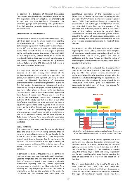
The presentation of <strong>the</strong> collected data is accomplished<br />
us<strong>in</strong>g forms that were grouped <strong>in</strong> two ma<strong>in</strong> categories<br />
(Fig. 2). The first group conta<strong>in</strong>s <strong>in</strong>formation of<br />
earthquake‐<strong>in</strong>duced liquefaction characteristics while <strong>the</strong><br />
second one <strong>in</strong>cludes data regard<strong>in</strong>g <strong>the</strong> liquefied site. The<br />
navigation <strong>in</strong>to <strong>the</strong> database is accomplished by an<br />
<strong>in</strong>troductive form which gives <strong>the</strong> researcher <strong>the</strong><br />
opportunity to select one of <strong>the</strong>se two groups for<br />
brows<strong>in</strong>g through its contents.<br />
Startup<br />
Greek / English<br />
Version<br />
Navigation <strong>in</strong>to <strong>the</strong> database Search<strong>in</strong>g specific data<br />
Data of liquefied sites Earthquake data Search<strong>in</strong>g a liquefied site Search<strong>in</strong>g an earthquake<br />
Plott<strong>in</strong>g <strong>in</strong>formation regard<strong>in</strong>g<br />
<strong>the</strong> liquefied site<br />
fault<br />
Earthquake<br />
Plott<strong>in</strong>g earthquake parameters<br />
Reference<br />
Description of<br />
Liquefaction-<strong>in</strong>duced<br />
failure<br />
Chart DALO v1.0<br />
Plott<strong>in</strong>g <strong>in</strong>formation regard<strong>in</strong>g<br />
The specific liquefied site<br />
Plott<strong>in</strong>g <strong>the</strong> earthquake parameters<br />
Liquefied site<br />
Fault<br />
Ground motion records<br />
Fig. 2: Chart of <strong>the</strong> Database of historical Liquefaction Occurrences<br />
where <strong>the</strong> correlations among <strong>the</strong> <strong>in</strong>troduced elements are shown<br />
Moreover, search<strong>in</strong>g for a specific liquefied site or an<br />
earthquake that triggered liquefaction phenomena is now<br />
possible <strong>and</strong> can be achieved by select<strong>in</strong>g <strong>the</strong> relatively<br />
options, appeared <strong>in</strong> <strong>the</strong> menu at <strong>the</strong> right side of <strong>the</strong><br />
<strong>in</strong>troductive form (figure 3). This search<strong>in</strong>g is realized<br />
us<strong>in</strong>g <strong>the</strong> primary keys of EqID <strong>and</strong> siteID, respectively<br />
<strong>and</strong> <strong>the</strong> user can ei<strong>the</strong>r select an earthquake based on <strong>the</strong><br />
date of occurrence or a liquefied site based on its<br />
location.<br />
The keys located at <strong>the</strong> left of <strong>the</strong> form (Fig. 3), lead to <strong>the</strong><br />
basic forms of DALO v1.0, Area <strong>and</strong> Earthquake,<br />
respectively, where <strong>in</strong>formation that were <strong>in</strong>troduced at<br />
<strong>the</strong> tables Earthquake <strong>and</strong> Area are presented. Moreover,<br />
<strong>the</strong> type of liquefaction‐<strong>in</strong>duced failure has been
