

Archaeoseismology and Palaeoseismology in the Alpine ... - Tierra
Archaeoseismology and Palaeoseismology in the Alpine ... - Tierra
Archaeoseismology and Palaeoseismology in the Alpine ... - Tierra

You also want an ePaper? Increase the reach of your titles
YUMPU automatically turns print PDFs into web optimized ePapers that Google loves.
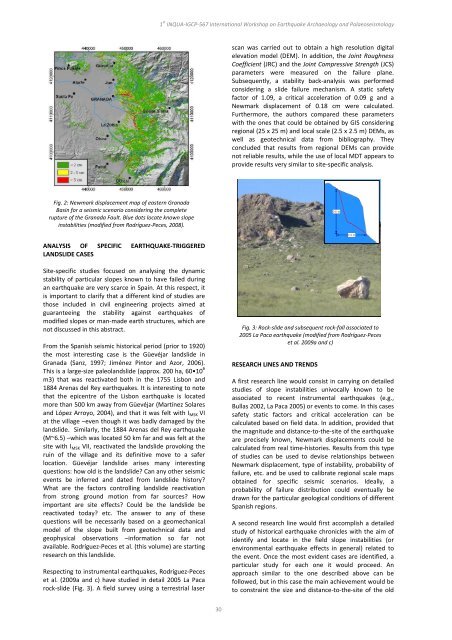
Fig. 2: Newmark displacement map of eastern Granada<br />
Bas<strong>in</strong> for a seismic scenario consider<strong>in</strong>g <strong>the</strong> complete<br />
rupture of <strong>the</strong> Granada Fault. Blue dots locate known slope<br />
<strong>in</strong>stabilities (modified from Rodríguez‐Peces, 2008).<br />
ANALYSIS OF SPECIFIC EARTHQUAKE‐TRIGGERED<br />
LANDSLIDE CASES<br />
Site‐specific studies focused on analys<strong>in</strong>g <strong>the</strong> dynamic<br />
stability of particular slopes known to have failed dur<strong>in</strong>g<br />
an earthquake are very scarce <strong>in</strong> Spa<strong>in</strong>. At this respect, it<br />
is important to clarify that a different k<strong>in</strong>d of studies are<br />
those <strong>in</strong>cluded <strong>in</strong> civil eng<strong>in</strong>eer<strong>in</strong>g projects aimed at<br />
guarantee<strong>in</strong>g <strong>the</strong> stability aga<strong>in</strong>st earthquakes of<br />
modified slopes or man‐made earth structures, which are<br />
not discussed <strong>in</strong> this abstract.<br />
From <strong>the</strong> Spanish seismic historical period (prior to 1920)<br />
<strong>the</strong> most <strong>in</strong>terest<strong>in</strong>g case is <strong>the</strong> Güevéjar l<strong>and</strong>slide <strong>in</strong><br />
Granada (Sanz, 1997; Jiménez P<strong>in</strong>tor <strong>and</strong> Azor, 2006).<br />
This is a large‐size paleol<strong>and</strong>slide (approx. 200 ha, 60•10 6<br />
m3) that was reactivated both <strong>in</strong> <strong>the</strong> 1755 Lisbon <strong>and</strong><br />
1884 Arenas del Rey earthquakes. It is <strong>in</strong>terest<strong>in</strong>g to note<br />
that <strong>the</strong> epicentre of <strong>the</strong> Lisbon earthquake is located<br />
more than 500 km away from Güevéjar (Martínez Solares<br />
<strong>and</strong> López Arroyo, 2004), <strong>and</strong> that it was felt with IMSK VI<br />
at <strong>the</strong> village –even though it was badly damaged by <strong>the</strong><br />
l<strong>and</strong>slide. Similarly, <strong>the</strong> 1884 Arenas del Rey earthquake<br />
(M~6.5) –which was located 50 km far <strong>and</strong> was felt at <strong>the</strong><br />
site with IMSK VII, reactivated <strong>the</strong> l<strong>and</strong>slide provok<strong>in</strong>g <strong>the</strong><br />
ru<strong>in</strong> of <strong>the</strong> village <strong>and</strong> its def<strong>in</strong>itive move to a safer<br />
location. Güevéjar l<strong>and</strong>slide arises many <strong>in</strong>terest<strong>in</strong>g<br />
questions: how old is <strong>the</strong> l<strong>and</strong>slide? Can any o<strong>the</strong>r seismic<br />
events be <strong>in</strong>ferred <strong>and</strong> dated from l<strong>and</strong>slide history?<br />
What are <strong>the</strong> factors controll<strong>in</strong>g l<strong>and</strong>slide reactivation<br />
from strong ground motion from far sources? How<br />
important are site effects? Could be <strong>the</strong> l<strong>and</strong>slide be<br />
reactivated today? etc. The answer to any of <strong>the</strong>se<br />
questions will be necessarily based on a geomechanical<br />
model of <strong>the</strong> slope built from geotechnical data <strong>and</strong><br />
geophysical observations –<strong>in</strong>formation so far not<br />
available. Rodríguez‐Peces et al. (this volume) are start<strong>in</strong>g<br />
research on this l<strong>and</strong>slide.<br />
Respect<strong>in</strong>g to <strong>in</strong>strumental earthquakes, Rodríguez‐Peces<br />
et al. (2009a <strong>and</strong> c) have studied <strong>in</strong> detail 2005 La Paca<br />
rock‐slide (Fig. 3). A field survey us<strong>in</strong>g a terrestrial laser<br />
1 st INQUA‐IGCP‐567 International Workshop on Earthquake Archaeology <strong>and</strong> <strong>Palaeoseismology</strong><br />
30<br />
scan was carried out to obta<strong>in</strong> a high resolution digital<br />
elevation model (DEM). In addition, <strong>the</strong> Jo<strong>in</strong>t Roughness<br />
Coefficient (JRC) <strong>and</strong> <strong>the</strong> Jo<strong>in</strong>t Compressive Strength (JCS)<br />
parameters were measured on <strong>the</strong> failure plane.<br />
Subsequently, a stability back‐analysis was performed<br />
consider<strong>in</strong>g a slide failure mechanism. A static safety<br />
factor of 1.09, a critical acceleration of 0.09 g <strong>and</strong> a<br />
Newmark displacement of 0.18 cm were calculated.<br />
Fur<strong>the</strong>rmore, <strong>the</strong> authors compared <strong>the</strong>se parameters<br />
with <strong>the</strong> ones that could be obta<strong>in</strong>ed by GIS consider<strong>in</strong>g<br />
regional (25 x 25 m) <strong>and</strong> local scale (2.5 x 2.5 m) DEMs, as<br />
well as geotechnical data from bibliography. They<br />
concluded that results from regional DEMs can provide<br />
not reliable results, while <strong>the</strong> use of local MDT appears to<br />
provide results very similar to site‐specific analysis.<br />
Fig. 3: Rock‐slide <strong>and</strong> subsequent rock‐fall associated to<br />
2005 La Paca earthquake (modified from Rodríguez‐Peces<br />
et al. 2009a <strong>and</strong> c)<br />
RESEARCH LINES AND TRENDS<br />
A first research l<strong>in</strong>e would consist <strong>in</strong> carry<strong>in</strong>g on detailed<br />
studies of slope <strong>in</strong>stabilities univocally known to be<br />
associated to recent <strong>in</strong>strumental earthquakes (e.g.,<br />
Bullas 2002, La Paca 2005) or events to come. In this cases<br />
safety static factors <strong>and</strong> critical acceleration can be<br />
calculated based on field data. In addition, provided that<br />
<strong>the</strong> magnitude <strong>and</strong> distance‐to‐<strong>the</strong>‐site of <strong>the</strong> earthquake<br />
are precisely known, Newmark displacements could be<br />
calculated from real time‐histories. Results from this type<br />
of studies can be used to devise relationships between<br />
Newmark displacement, type of <strong>in</strong>stability, probability of<br />
failure, etc. <strong>and</strong> be used to calibrate regional scale maps<br />
obta<strong>in</strong>ed for specific seismic scenarios. Ideally, a<br />
probability of failure distribution could eventually be<br />
drawn for <strong>the</strong> particular geological conditions of different<br />
Spanish regions.<br />
A second research l<strong>in</strong>e would first accomplish a detailed<br />
study of historical earthquake chronicles with <strong>the</strong> aim of<br />
identify <strong>and</strong> locate <strong>in</strong> <strong>the</strong> field slope <strong>in</strong>stabilities (or<br />
environmental earthquake effects <strong>in</strong> general) related to<br />
<strong>the</strong> event. Once <strong>the</strong> most evident cases are identified, a<br />
particular study for each one it would proceed. An<br />
approach similar to <strong>the</strong> one described above can be<br />
followed, but <strong>in</strong> this case <strong>the</strong> ma<strong>in</strong> achievement would be<br />
to constra<strong>in</strong>t <strong>the</strong> size <strong>and</strong> distance‐to‐<strong>the</strong>‐site of <strong>the</strong> old
