

Archaeoseismology and Palaeoseismology in the Alpine ... - Tierra
Archaeoseismology and Palaeoseismology in the Alpine ... - Tierra
Archaeoseismology and Palaeoseismology in the Alpine ... - Tierra

You also want an ePaper? Increase the reach of your titles
YUMPU automatically turns print PDFs into web optimized ePapers that Google loves.
1 st INQUA‐IGCP‐567 International Workshop on Earthquake Archaeology <strong>and</strong> <strong>Palaeoseismology</strong><br />
QUANTITATIVE METHODS IN ARCHAEOSEISMOLOGY<br />
K.G. H<strong>in</strong>zen (1), C. Fleischer (1), S. K. Reamer (1), S. Schreiber (1), S. Schütte (2) <strong>and</strong> B. Yerli (3)<br />
(1) Earthquake Geology Group, Cologne University, V<strong>in</strong>zenz‐Pallotti‐Str. 26, 51429 Bergisch Gladbach. GERMANY. h<strong>in</strong>zen@uni‐koeln.de<br />
(2) Archaeological Zone Cologne, City of Cologne, Heumarkt 64‐66, 50667 Köln, GERMANY<br />
(3) Institute Geology, M<strong>in</strong>eralogy <strong>and</strong> Geophysics, Ruhr‐Universität Bochum, Universitätsstraße 150, 44801 Bochum, GERMANY.<br />
Abstract: With<strong>in</strong> <strong>the</strong> multidiscipl<strong>in</strong>ary field of archaeoseismology, quantitative methods have begun to be utilized more prevalently. We<br />
propose a scheme of apply<strong>in</strong>g quantitative models to test <strong>the</strong> seismogenic hypo<strong>the</strong>sis of observed damages. The comb<strong>in</strong>ation of 3D structural<br />
models of build<strong>in</strong>gs or <strong>the</strong>ir rema<strong>in</strong>s based on phase shift laser scanner measurements with high resolution digital images allow <strong>the</strong><br />
construction of damage <strong>and</strong>/or deformation <strong>in</strong>ventory <strong>and</strong> assists <strong>the</strong> archaeological work dur<strong>in</strong>g an excavation. 3D surface meshes derived<br />
from <strong>the</strong> same scan data are <strong>the</strong> basis for F<strong>in</strong>ite or Discrete Element models of <strong>the</strong> structures. The effect of site‐specific earthquake‐related<br />
ground motions, o<strong>the</strong>r natural causes, <strong>and</strong> anthropogenic <strong>in</strong>fluences, are simulated <strong>and</strong> compared with <strong>the</strong> damage <strong>in</strong>ventory. However, due<br />
to <strong>the</strong> high level of complexity of <strong>the</strong> problems no def<strong>in</strong>ite answers should be expected from quantitative models <strong>in</strong> all cases.<br />
Key words: Quantitative Methods, archaeoseismology.<br />
INTRODUCTION<br />
The early approaches <strong>in</strong> <strong>the</strong> relatively young field of<br />
archaeoseismology were qualitative, consist<strong>in</strong>g ma<strong>in</strong>ly of<br />
descriptions of observed damages <strong>in</strong> archaeological<br />
excavations <strong>and</strong> were often highly speculative with<br />
regards to <strong>the</strong> damage processes. Increas<strong>in</strong>gly,<br />
quantitative models have recently begun to be employed.<br />
Gallad<strong>in</strong>i et al. (2006) summarized complete<br />
archaeoseismic studies <strong>in</strong> a flow chart, emphasiz<strong>in</strong>g<br />
quantitative models as crucial tools to validate or<br />
elim<strong>in</strong>ate a seismogenic hypo<strong>the</strong>sis, which usually forms<br />
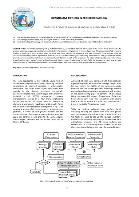
<strong>the</strong> basis for an archaeoseismic <strong>in</strong>vestigation. In Fig. 1, we<br />
propose a scheme that concentrates on archaeoseismic<br />
problems <strong>in</strong> which off‐fault ground motions are <strong>the</strong><br />
suspected cause of damages to manmade structures. We<br />
apply this scheme <strong>in</strong> two projects: <strong>the</strong> Archaeological<br />
Zone Cologne, Germany <strong>and</strong> <strong>the</strong> ancient Lycian City of<br />
P<strong>in</strong>ara, SW Turkey.<br />
Conclude<br />
Damage<br />
Inventory<br />
Compare<br />
3D Scans,<br />
Color Images<br />
Orthophotos<br />
Crosscuts<br />
3D Meshes<br />
Reconstruction<br />
50<br />
LASER SCANNING<br />
Advanced 3D laser scans comb<strong>in</strong>ed with high‐resolution<br />
digital photographs allow detailed damage analysis even<br />
for cases where <strong>the</strong> stability of <strong>the</strong> excavated objects,<br />
safety or <strong>the</strong> lack of time prevents a thorough classical<br />
archaeological documentation. (An example will be given<br />
<strong>in</strong> <strong>the</strong> accompany<strong>in</strong>g paper of Schreiber et al., 2009).<br />
Us<strong>in</strong>g <strong>the</strong> phase shift <strong>in</strong>stead of travel time of <strong>the</strong> laser<br />
beam allows very rapid data acquisition with several<br />
million po<strong>in</strong>ts per m<strong>in</strong>ute <strong>and</strong> results <strong>in</strong> a resolution of 1‐<br />
2 mm <strong>in</strong> <strong>the</strong> 0.5 to 75 m distance range.<br />
While we comb<strong>in</strong>e <strong>in</strong>dividual scans, perform signal‐<br />
enhanc<strong>in</strong>g filter<strong>in</strong>g <strong>and</strong> comb<strong>in</strong>ation with color photos<br />
with <strong>the</strong> Reconstructor software tool, st<strong>and</strong>ard CAD <strong>and</strong><br />
GIS tools are used to set up <strong>the</strong> damage <strong>in</strong>ventory.<br />
Parallel to this <strong>in</strong>ventory <strong>and</strong> based on <strong>the</strong> same raw data,<br />
orthophotos, crosscuts <strong>and</strong> 3D mesh surfaces are<br />
constructed. In excavation‐parallel studies, as <strong>in</strong> <strong>the</strong><br />
above‐mentioned Cologne field case, <strong>the</strong> scanned images<br />
DEM, Boreholes,<br />
Samples, Geophysics<br />
Geotechnical<br />
Model<br />
FE & FD Models of <strong>the</strong><br />
Damaged Stuctures<br />
Dynamic Behaviour<br />
Build<strong>in</strong>g Capacity<br />
Ground Motion<br />
Seismotectonic<br />
Seismicity<br />
Seismological<br />
Model<br />
Fig. 1: Schematic flow chart of quantitative archaeoseismic modell<strong>in</strong>g.<br />
O<strong>the</strong>r Natural or<br />
Man Made Effcts
