

Archaeoseismology and Palaeoseismology in the Alpine ... - Tierra
Archaeoseismology and Palaeoseismology in the Alpine ... - Tierra
Archaeoseismology and Palaeoseismology in the Alpine ... - Tierra

You also want an ePaper? Increase the reach of your titles
YUMPU automatically turns print PDFs into web optimized ePapers that Google loves.
po<strong>in</strong>t was about 80 cm along <strong>the</strong> shorel<strong>in</strong>e edge with<br />
discernable vertical displacement. Some en echelon<br />
faults <strong>in</strong> <strong>the</strong> deeper portion of <strong>the</strong> bay about 200 m<br />
from <strong>the</strong> shore were likewise reported by local<br />
fishermen.<br />
Fig. 4: Photograph (look<strong>in</strong>g WSW) show<strong>in</strong>g <strong>the</strong> ground rupture<br />
produced along <strong>the</strong> coastl<strong>in</strong>e <strong>in</strong> Suba, Dimasalang. Note <strong>the</strong><br />
shorel<strong>in</strong>e that was displaced approximately by 0.8m <strong>and</strong> <strong>the</strong><br />
subtle uplift/mound <strong>in</strong> <strong>the</strong> foreground of <strong>the</strong> photo<br />
About 25 m from <strong>the</strong> shore, <strong>the</strong> trace can be followed<br />
along <strong>the</strong> N48 o W trend<strong>in</strong>g fault transect<strong>in</strong>g <strong>the</strong> s<strong>and</strong>y<br />
beach berm. In <strong>the</strong> beach terrace, <strong>the</strong> fault also<br />
transected two semi‐concrete houses <strong>and</strong> numerous<br />
wooden fences. The wooden fence was displaced<br />
horizontally <strong>and</strong> vertically (northwest block up) by<br />
20cm <strong>and</strong> 18cm, respectively<br />
‐ Palanas area<br />
In Sta. Cruz, Palanas, <strong>the</strong> ground rupture also displaced<br />
several man‐made structures <strong>in</strong>clud<strong>in</strong>g semi‐concrete<br />
to concrete houses, wooden fences, rice paddy dikes<br />
<strong>and</strong> roads <strong>and</strong> foot trails. Inside one of <strong>the</strong> gardens, a<br />
displaced foot trail (20 cm horizontal displacement)<br />
was observed with well‐formed mole track. Moreover,<br />
a semi‐concrete house <strong>and</strong> a wooden house <strong>in</strong> <strong>the</strong><br />
same village were transected by <strong>the</strong> fault.<br />
Southwards <strong>and</strong> <strong>in</strong>to Nabangig, Palanas <strong>in</strong> Sitio<br />
Matugnaw, a foot trail was transected by <strong>the</strong> ground<br />
rupture. The trail was horizontally displaced by 45 cm<br />
with negligible vertical displacement (site r <strong>in</strong> Fig. 3). In<br />
this area, <strong>the</strong> en echelon faults have a N60 o W trend<br />
while <strong>the</strong> ground rupture is trend<strong>in</strong>g N40 o W <strong>and</strong> about<br />
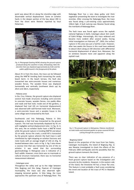
10 cm wide. Across <strong>the</strong> creek, a small hill is transected<br />
by <strong>the</strong> ground rupture where<strong>in</strong> <strong>the</strong> fault trace is well<br />
manifested by right‐stepp<strong>in</strong>g en echelon fractures <strong>and</strong><br />
mole tracks with an average length of 150 cm (Fig. 5)<br />
located between sites r <strong>and</strong> s <strong>in</strong> Fig. 3. Fig. 5 also shows<br />
a coconut tree that was transected by one of <strong>the</strong> en<br />
echelon. It was noted that <strong>the</strong> surround<strong>in</strong>g<br />
geomorphology <strong>in</strong> Matugnaw area is <strong>in</strong>dicative of a<br />
fault saddle. However, s<strong>in</strong>ce <strong>the</strong>re was no manmade or<br />
cultural structure transected, <strong>the</strong>re was no horizontal<br />
measurement obta<strong>in</strong>ed.<br />
‐ Cata<strong>in</strong>gan area<br />
Throughout <strong>the</strong> valley <strong>and</strong> up to <strong>the</strong> ridge between<br />
Sitio Bogtong <strong>and</strong> Sito Salag, Pawican of Cata<strong>in</strong>gan<br />
municipality, <strong>the</strong> trace was also observed right‐<br />
stepp<strong>in</strong>g tensional gashes. In Sitio Salag, <strong>the</strong> trace<br />
approaches <strong>the</strong> upstream area of Nabangig River. The<br />
1 st INQUA‐IGCP‐567 International Workshop on Earthquake Archaeology <strong>and</strong> <strong>Palaeoseismology</strong><br />
10<br />
Nabangig River has a very deep gulley <strong>and</strong> thick<br />
vegetation prevent<strong>in</strong>g <strong>the</strong> team to <strong>in</strong>vestigate <strong>the</strong> river<br />
vic<strong>in</strong>ities. After cross<strong>in</strong>g <strong>the</strong> Nabangig River, <strong>the</strong> trace<br />
was found along a pre‐exist<strong>in</strong>g scarp approximately<br />
150cm high. A fault outcrop was likewise found along<br />
<strong>the</strong> riverbank of Nabangig River.<br />
The fault trace was found aga<strong>in</strong> across <strong>the</strong> asphalt<br />
national highway <strong>in</strong> Gahit, Cata<strong>in</strong>gan about 1km south<br />
of Gahit Bridge. Interest<strong>in</strong>gly, this trace widened <strong>and</strong><br />
became more evident after several weeks. Dur<strong>in</strong>g<br />
<strong>in</strong>itial <strong>in</strong>vestigation on February 19 th , 2003, <strong>the</strong> surface<br />
rupture <strong>in</strong> this area was just a hairl<strong>in</strong>e crack. However,<br />
after two weeks <strong>the</strong> fissure <strong>in</strong> this road have widened<br />
to about 0.8cm along an EW direction with differential<br />
horizontal displacement of about 3cm. Moreover, <strong>the</strong><br />
en echelons became more <strong>and</strong> apparent along <strong>the</strong><br />
asphalt road.<br />
Fig. 5: The ground rupture <strong>in</strong> Matugnaw, Palanas manifested<br />
as mole tracks <strong>and</strong> tensional gashes on grass‐covered hill also<br />
cutt<strong>in</strong>g through <strong>the</strong> coconut tree.<br />
‐ Bogtong Isl<strong>and</strong><br />
Based on <strong>the</strong> projection of <strong>the</strong> trace from San Pedro,<br />
Cata<strong>in</strong>gan municipality, <strong>the</strong> Isl<strong>and</strong> of Bogtong (Fig. 1)<br />
was likewise <strong>in</strong>vestigated to check <strong>the</strong> effects of <strong>the</strong><br />
February 2003 earthquake <strong>and</strong> <strong>the</strong> possibility that <strong>the</strong><br />
ground rupture transects <strong>the</strong> isl<strong>and</strong>.<br />
There was no clear <strong>in</strong>dication of any presence of a<br />
fresh ground rupture based on <strong>the</strong> <strong>in</strong>vestigation <strong>and</strong><br />
accounts by <strong>the</strong> residents. However, <strong>in</strong> <strong>the</strong> eastern side<br />
of <strong>the</strong> isl<strong>and</strong>, <strong>the</strong> limestone hill has a l<strong>in</strong>ear flat area.<br />
This feature is most probably a fault scarp consider<strong>in</strong>g<br />
<strong>the</strong> trend <strong>and</strong> location of <strong>the</strong> trace of PFZ <strong>in</strong> Masbate<br />
Isl<strong>and</strong>.
