

Archaeoseismology and Palaeoseismology in the Alpine ... - Tierra
Archaeoseismology and Palaeoseismology in the Alpine ... - Tierra
Archaeoseismology and Palaeoseismology in the Alpine ... - Tierra

Create successful ePaper yourself
Turn your PDF publications into a flip-book with our unique Google optimized e-Paper software.
1 st INQUA‐IGCP‐567 International Workshop on Earthquake Archaeology <strong>and</strong> <strong>Palaeoseismology</strong><br />
A RARE CASE OF PRESERVED EARTHQUAKE RUPTURES IN AN<br />
ARCHAEOLOGICAL SITE: MIKRI DOXIPARA – ZONI, NE GREECE<br />
A. Chatzipetros (1) <strong>and</strong> S. Pavlides (1)<br />
(1) Department of Geology, Aristotle University, 54124, Thessaloniki, GREECE. ac@auth.gr<br />
Abstract: This abstract describes <strong>the</strong> results of an archaeoseismological / palaeoseismological research at <strong>the</strong> site of Mikri Doxipara – Zoni (NE<br />
Greece). Faulted layers, surface ruptures, displaced structures, fissures etc. <strong>in</strong>dicate that this site has undergone severe deformation dur<strong>in</strong>g at<br />
least two large, ground ruptur<strong>in</strong>g earthquakes. Radiocarbon dat<strong>in</strong>g <strong>and</strong> detailed log analysis suggest that <strong>the</strong>se two earthquakes probably<br />
happened <strong>in</strong> 1752 (Edirne earthquake) <strong>and</strong> after 960 ± 50 BC. Both earthquakes produced vertical displacement <strong>in</strong> <strong>the</strong> order of 0.9‐1 m,<br />
<strong>the</strong>refore <strong>the</strong>ir magnitude is estimated at ca. 6.5. This site is unique <strong>in</strong> <strong>the</strong> sense that fault<strong>in</strong>g is directly correlated to archaeological<br />
deformation.<br />
Key words: archaeoseismology, palaeoseismology, surface ruptures, Greece<br />
INTRODUCTION – SETTING<br />
Mikri Doxipara – Zoni excavation site (MDZ) is a Roman<br />
burial site located <strong>in</strong> <strong>the</strong> low seismicity Evros region (NW<br />
Greece), very close to <strong>the</strong> Greek‐Bulgarian‐Turkish<br />
borders (Fig. 1).<br />
Fig. 1: Location map of Mikri Doxipara – Zoni site <strong>in</strong> NE Greece. It<br />
is <strong>in</strong> close proximity to <strong>the</strong> well known Roman cities of<br />
Hadrianoupolis, Plot<strong>in</strong>opolis <strong>and</strong> Trajanoupolis.<br />
The MDZ site is located on a vantage elevated po<strong>in</strong>t, as it<br />
is built on a hill overlook<strong>in</strong>g <strong>the</strong> Vardas river valley. The<br />
site was also near <strong>the</strong> commercial roads l<strong>in</strong>k<strong>in</strong>g<br />
Hadrianoupolis, Plot<strong>in</strong>opolis <strong>and</strong> Hadrianopolis.<br />
The area around MDZ site is modified by both <strong>the</strong> erosion<br />
of Ardas river system <strong>in</strong> <strong>the</strong> closer area <strong>and</strong> Evros river <strong>in</strong><br />
<strong>the</strong> broader, as well as by a set of normal faults rang<strong>in</strong>g <strong>in</strong><br />
strike from WNW‐ESE to WSW‐ENE (Fig. 2). This fault<br />
system has caused <strong>the</strong> Neogene sediments (locally<br />
consisted of marl <strong>and</strong> f<strong>in</strong>e to medium gra<strong>in</strong>ed s<strong>and</strong>) to<br />
form a set of hills roughly oriented E‐W, smoo<strong>the</strong>d out<br />
due to erosion. Relief is not strik<strong>in</strong>gly modified by faults,<br />
<strong>the</strong>refore <strong>the</strong>y would normally considered to be <strong>in</strong>active<br />
or of low activity (Pavlides et al., 2006a <strong>and</strong> b, 2007).<br />
20<br />
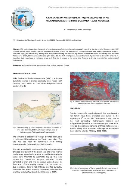
Fig. 2: L<strong>and</strong>sat image show<strong>in</strong>g <strong>the</strong> ma<strong>in</strong> fault systems that modify<br />
<strong>the</strong> area around Mikri Doxipara – Zoni site.<br />
DISCUSSION<br />
The site consists of a tumulus <strong>in</strong> which four members of a<br />
rich family have been cremated <strong>and</strong> buried <strong>in</strong> <strong>the</strong><br />
beg<strong>in</strong>n<strong>in</strong>g of 2 nd century AD. The tumulus is very close to<br />
<strong>the</strong> road connect<strong>in</strong>g Hadrianopolis (Edirne) <strong>and</strong><br />
Philippoupolis (Plovdid). Four excavation pits s<strong>in</strong>ce 2002,<br />
revealed <strong>the</strong> cremated rema<strong>in</strong>s of three males <strong>and</strong> one<br />
female, along with numerous offer<strong>in</strong>gs to accompany<br />
<strong>the</strong>m <strong>in</strong>to <strong>the</strong> afterlife (Whitley, 2002‐2003).<br />
Fig. 3: Initial topography of <strong>the</strong> tumulus before <strong>the</strong> excavation. It<br />
is evident that <strong>the</strong> tumulus is deformed <strong>in</strong> an E‐W direction<br />
(photo courtesy: D. Triantafyllos).
