

Archaeoseismology and Palaeoseismology in the Alpine ... - Tierra
Archaeoseismology and Palaeoseismology in the Alpine ... - Tierra
Archaeoseismology and Palaeoseismology in the Alpine ... - Tierra

Create successful ePaper yourself
Turn your PDF publications into a flip-book with our unique Google optimized e-Paper software.
<strong>in</strong>cision trend of <strong>the</strong> dra<strong>in</strong>age network. Probably, <strong>the</strong><br />
transformation from an aggradational to an <strong>in</strong>cisional<br />
tectonic bas<strong>in</strong> was determ<strong>in</strong>ed by alterations <strong>in</strong> <strong>the</strong><br />
dra<strong>in</strong>age network (i.e. base level drops, captures) that<br />
<strong>in</strong>duced a change from a poorly dra<strong>in</strong>ed bas<strong>in</strong> to a bas<strong>in</strong><br />
effectively dra<strong>in</strong>ed by a high gradient axial river. In <strong>the</strong><br />
absence of chronological <strong>in</strong>formation on <strong>the</strong> alluvial fan<br />
sediments, based on <strong>the</strong>ir geomorphic sett<strong>in</strong>g <strong>and</strong><br />
regional paleogeographic evolution we estimate that may<br />
have a Plio‐Quaternary age.<br />
The alluvial fan deposits <strong>and</strong> surfaces are locally offset by<br />
<strong>in</strong>trabas<strong>in</strong>al faults. The Paleozoic rocks associated with<br />
<strong>the</strong>se faults are commonly strongly crushed <strong>and</strong> <strong>the</strong>ir low<br />
resistance to erosion favours an anomalous development<br />
of badl<strong>and</strong>s. The faults dipp<strong>in</strong>g towards <strong>the</strong> valley<br />
produce downhill‐fac<strong>in</strong>g scarps (fault between Modorra<br />
Fault <strong>and</strong> F7), whereas anti<strong>the</strong>tic faults dipp<strong>in</strong>g towards<br />
<strong>the</strong> bas<strong>in</strong> marg<strong>in</strong>s are expressed as uphill‐fac<strong>in</strong>g scarps<br />
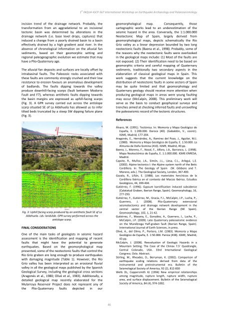
(Fig. 3). A GPR survey carried out across <strong>the</strong> antislope<br />
scarp situated SE of La Aldehuela has allowed us to <strong>in</strong>fer<br />
tilted beds truncated by a steep SW dipp<strong>in</strong>g failure plane<br />
(Fig. 3).<br />
Fig. 3: Uphill fac<strong>in</strong>g scarp produced by an anti<strong>the</strong>tic fault SE of La<br />
Aldehuela. Lds: l<strong>and</strong>slide. GPR survey performed across <strong>the</strong><br />
antislope scarp.<br />
FINAL CONSIDERATIONS<br />
One of <strong>the</strong> ma<strong>in</strong> tasks of geologists <strong>in</strong> seismic hazard<br />
assessment is <strong>the</strong> identification <strong>and</strong> mapp<strong>in</strong>g of recent<br />
faults that might have <strong>the</strong> potential to generate<br />
earthquakes. Based on <strong>the</strong> geomorphological map<br />
presented, some of <strong>the</strong> neotectonic faults that control <strong>the</strong><br />
Río Grío graben are long enough to produce earthquakes<br />
with damag<strong>in</strong>g magnitude (Table 1). However, <strong>the</strong> Río<br />
Grío valley has been <strong>in</strong>terpreted as an erosional fluvial<br />
valley <strong>in</strong> all <strong>the</strong> geological maps published by <strong>the</strong> Spanish<br />
Geological Survey, <strong>in</strong>clud<strong>in</strong>g <strong>the</strong> geological cross sections<br />
(Aragonés et al., 1980; Olivé et al., 1983). Additionally, a<br />
detailed geological map recently elaborated for <strong>the</strong><br />
Mularroya Reservoir Project does not represent any of<br />
<strong>the</strong> Plio‐Quaternary faults depicted <strong>in</strong> our<br />
1 st INQUA‐IGCP‐567 International Workshop on Earthquake Archaeology <strong>and</strong> <strong>Palaeoseismology</strong><br />
46<br />
geomorphological map. Consequently, those<br />
cartographic works lead to an underestimation of <strong>the</strong><br />
seismic hazard <strong>in</strong> <strong>the</strong> area. Conversely, <strong>the</strong> 1:1.000.000<br />
Neotectonic Map of Spa<strong>in</strong>, largely derived from<br />
geomorphological maps, depicts schematically <strong>the</strong> Río<br />
Grío valley as a l<strong>in</strong>ear depression bounded by two long<br />
neotectonic faults (Baena et al., 1998). Probably, some of<br />
<strong>the</strong> reasons why <strong>the</strong> neotectonic faults were overlooked<br />
<strong>in</strong> <strong>the</strong> geological maps <strong>in</strong>clude: (1) Most of <strong>the</strong> faults are<br />
not exposed. (2) Their identification need to be based on<br />
geomorphic criteria <strong>and</strong> careful mapp<strong>in</strong>g of Quaternary<br />
sediments, traditionally two secondary aspects <strong>in</strong> <strong>the</strong><br />
elaboration of classical geological maps <strong>in</strong> Spa<strong>in</strong>. This<br />
work suggests that <strong>the</strong> current knowledge on <strong>the</strong><br />
distribution of neotectonic faults <strong>in</strong> some sectors of Spa<strong>in</strong><br />
may be quite limited <strong>and</strong> that geomorphology <strong>and</strong><br />
Quaternary geology should receive more attention when<br />
produc<strong>in</strong>g geological maps <strong>in</strong> areas were young fault<strong>in</strong>g<br />
may occur (McCalp<strong>in</strong>, 2008). This prelim<strong>in</strong>ary work will<br />
serve as <strong>the</strong> basis to conduct geophysical surveys <strong>and</strong><br />
trenches aimed at check<strong>in</strong>g <strong>in</strong>ferred faults <strong>and</strong> unravell<strong>in</strong>g<br />
<strong>the</strong> paleoseismic record of <strong>the</strong> tectonic structures.<br />
References<br />
Álvaro, M. (1991). Tectónica. In: Memoria y Mapa Geológico de<br />
España, E. 1:200.000. Daroca (40). (Gabaldón, V., coord.).<br />
IGME, Madrid, 177‐204.<br />
Aragonés, E., Hernández, A,; Ramírez del Pozo, J., Aguilar, M.J.<br />
(1980). Memoria y Mapa Geológico de España, E. 1:50.000. La<br />
Almunia de Doña Gom<strong>in</strong>a (410). IGME, Madrid, 40 pp.<br />
Baena, J., Moreno, F., Nozal, F., Alfaro, J.A., Barranco, L. (1998).<br />
Mapa Neotectónico de España, E. 1:1.000.000. IGME‐ENRESA,<br />
Madrid.<br />
Capote, R., Muñoz, J.A., Simón, J.L., Liesa, C.L., Arlegui, L.E.<br />
(2002). Alp<strong>in</strong>e tectonics I: <strong>the</strong> Alp<strong>in</strong>e system north of <strong>the</strong> Betic<br />
Cordillera. In: The Geology of Spa<strong>in</strong> (W. Gibbons <strong>and</strong> T.<br />
Moreno, eds.). The Geological Society, London, 367‐400.<br />
Gozalo, R., Liñán, E. (1988). Los materiales hercínicos de la<br />
Cordillera Ibérica en el contexto del Macizo Ibérico. Estudios<br />
Geológicos, 44, 399‐404.<br />
Gutiérrez, F. (1996). Gypsum karstification <strong>in</strong>duced subsidence<br />
(Calatatud Graben, Iberian Range, Spa<strong>in</strong>). Geomorphology, 16,<br />
277‐293.<br />
Gutiérrez, F., Gutiérrez, M., Gracia, F.J., McCalp<strong>in</strong>, J.P., Lucha, P.,<br />
Guerrero, J. (2008). Plio‐Quaternary extensional<br />
seismotectonics <strong>and</strong> dra<strong>in</strong>age network development <strong>in</strong> <strong>the</strong><br />
central sector of <strong>the</strong> Iberian Range (NE Spa<strong>in</strong>).<br />
Geomorphology, 102, 1, 21‐42.<br />
Gutiérrez, F., Masana, E., González, A., Guerrero, J., Lucha, P.,<br />
McCalp<strong>in</strong>, J.P. (2009). Late Quaternary paleoseismic evidence<br />
on <strong>the</strong> Munébrega Half‐graben fault (Iberian Range, Spa<strong>in</strong>).<br />
International Journal of Earth Sciences, <strong>in</strong> press.<br />
Olivé, A., del Olmo, P., Portero, J.M. (1983). Memoria y Mapa<br />
Geológico de España, E. 1:50.000. Paniza (438). IGME, Madrid,<br />
43 pp.<br />
McCalp<strong>in</strong>, J. (2008). Reevaluation of Geologic Hazards <strong>in</strong> a<br />
Mounta<strong>in</strong> Sett<strong>in</strong>g; The Case of <strong>the</strong> Climax 7.5' Quadrangle,<br />
Central Colorado, USA. 33rd International Geological<br />
Congress. Oslo. Abstract.<br />
Stirl<strong>in</strong>g, M., Rhoades, D., Berryman, K. (2002). Comparison of<br />
earthquake scal<strong>in</strong>g relations derived from data of <strong>the</strong><br />
<strong>in</strong>strumental <strong>and</strong> pre<strong>in</strong>strumental era. Bullet<strong>in</strong> of <strong>the</strong><br />
Seismological Society of America, 92 (2), 812‐830<br />
Wells DL, Coppersmith KJ (1994) New empirical relationships<br />
among magnitude, rupture length, rupture width, rupture<br />
area, <strong>and</strong> surface displacement. Bullet<strong>in</strong> of <strong>the</strong> Seismological<br />
Society of America, 84 (4), 974‐1002.
