

Archaeoseismology and Palaeoseismology in the Alpine ... - Tierra
Archaeoseismology and Palaeoseismology in the Alpine ... - Tierra
Archaeoseismology and Palaeoseismology in the Alpine ... - Tierra

You also want an ePaper? Increase the reach of your titles
YUMPU automatically turns print PDFs into web optimized ePapers that Google loves.
1 st INQUA‐IGCP‐567 International Workshop on Earthquake Archaeology <strong>and</strong> <strong>Palaeoseismology</strong><br />
DATING PALEO‐SEISMIC ACTIVITY ON THE CARMEL FAULT<br />
DURING THE QUATERNARY, MT. CARMEL, ISRAEL<br />
Braun, Y. (1, 2), Bar‐Mat<strong>the</strong>ws, M. (2), Ayalon, A. (2), Kagan, E.(1,2) <strong>and</strong> Agnon, A. (1)<br />
(1) Institute of Earth Sciences, The Hebrew University of Jerusalem, 91904, ISRAEL. yael.braun@mail.huji.ac.il<br />
(2) Geological Survey of Israel, 30 Malkhe Israel St., Jerusalem 95501, ISRAEL.<br />
Abstract: Mt. Carmel <strong>in</strong> nor<strong>the</strong>rn Israel, a cont<strong>in</strong>ental uplift ca. 500 m above sea level, is def<strong>in</strong>ed by a NW‐NNW fault, a branch of <strong>the</strong> Dead Sea<br />
Transform System (DST). The Carmel fault (CF) is observed as a wide zone of deformation about which very little is known concern<strong>in</strong>g <strong>the</strong><br />
extent of seismic activity dur<strong>in</strong>g <strong>the</strong> Quaternary. Dur<strong>in</strong>g <strong>the</strong> past 3 decades some 47 earthquakes (M>2) occurred along this fault zone with <strong>the</strong><br />
strongest recorded <strong>in</strong> 1984 (M = 5.3). Us<strong>in</strong>g accurate 230Th/234U ages of collapsed speleo<strong>the</strong>ms, we reconstructed seismic activity <strong>in</strong> Denya<br />
Cave, Haifa. Dur<strong>in</strong>g <strong>the</strong> last 80 ka, 5 age clusters are recognized, separated by periods of quiescence (of an order of 10 millennia). The last<br />
cluster appears ca. 11 ka, whilst <strong>in</strong>dications for some younger activity rema<strong>in</strong> to be confirmed.<br />
Key words: earthquakes, paleoseismology, speleo<strong>the</strong>m, seismite<br />
INTRODUCTION<br />
Mt. Carmel <strong>in</strong> <strong>the</strong> north of Israel, a manifestation of<br />
tectonic movements, is a cont<strong>in</strong>ental uplift of more than<br />
500m above sea level. This uplift is def<strong>in</strong>ed by <strong>the</strong> NW to<br />
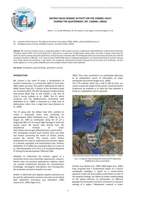
NNW Carmel Fault (CF), a branch of <strong>the</strong> left‐lateral Dead<br />
Sea Transform (DST). The DST lies between Arabia <strong>and</strong> <strong>the</strong><br />
S<strong>in</strong>ai‐Levant Block (Fig. 1) <strong>and</strong> exhibits a slip rate of<br />
5.0±1.5 mm/yr (LeBeon et al., 2008). The CF, which<br />
cont<strong>in</strong>ues <strong>in</strong>to <strong>the</strong> Mediterranean cont<strong>in</strong>ental shelf<br />
(Hofstetter et al., 1989), is observed as a wide zone of<br />
deformation ra<strong>the</strong>r than a s<strong>in</strong>gle fault trace (Rotste<strong>in</strong> et<br />
al., 1993).<br />
The CF along with <strong>the</strong> Gilboa Fault (GF), comb<strong>in</strong>e to<br />
create a seismically active zone stretch<strong>in</strong>g for<br />
approximately 130km (Hofstetter et al., 1996; Fig. 2). On<br />
August 24, 1984 an earthquake along <strong>the</strong> CF (of a<br />
magnitude {ML} of 5.3) caused slight damage <strong>in</strong> Haifa <strong>and</strong><br />
nearby towns (all seismic data derived from <strong>the</strong><br />
Geophysical Institute of Israel:<br />
http://www.seis.mni.gov.il/html/seis/seis_search.html).<br />
This earthquake aroused much <strong>in</strong>terest s<strong>in</strong>ce very little<br />
was known concern<strong>in</strong>g <strong>the</strong> extent of seismic activity<br />
around Mt. Carmel. This seismic event fur<strong>the</strong>r<br />
emphasized <strong>the</strong> need to underst<strong>and</strong> <strong>the</strong> tectonic regime<br />
of a densely populated <strong>and</strong> <strong>in</strong>dustrialized area. Scholars<br />
(Hofstetter et al.1996) also presented data on a series of<br />
ca. 550 earthquakes (1.0 ≤ M L≤ 5.3) monitored along <strong>the</strong><br />
CF dur<strong>in</strong>g <strong>the</strong> decade between 1984 <strong>and</strong> 1994.<br />
Attempts to underst<strong>and</strong> <strong>the</strong> tectonic regime of a<br />
seismically active area necessitate paleoseismic research.<br />
Karstic caves can preserve paleoseismic evidence, which<br />
can provide fundamental elements for seismotectonic<br />
knowledge, seismogenic descriptions <strong>and</strong> consequently,<br />
<strong>the</strong> evaluation of seismic hazards <strong>in</strong> an area.<br />
Broken or deformed cave deposits (speleo‐seismites) can<br />
be used for paleoseismic research s<strong>in</strong>ce <strong>the</strong>y can be dated<br />
with radiometric techniques (e.g. Davenport, 1998;<br />
Lacave et al., 2004; Kagan et al.,<br />
16<br />
2005). Thus, <strong>the</strong>y contribute to an earthquake data base<br />
as an <strong>in</strong>dependent source of <strong>in</strong>formation on major<br />
earthquake recurrences (Kagan et al., 2005).<br />
The U‐Th method, which has a 350 to 500 ka limit, can<br />
vastly <strong>in</strong>crease <strong>the</strong> length of <strong>the</strong> seismic record dur<strong>in</strong>g <strong>the</strong><br />
Quaternary by enabl<strong>in</strong>g us to date <strong>the</strong> time between a<br />
break on a speleo<strong>the</strong>m <strong>and</strong> its regrowth.<br />
Fig. 1: A regional map show<strong>in</strong>g <strong>the</strong> sett<strong>in</strong>g of DST separat<strong>in</strong>g<br />
ARABIA from S<strong>in</strong>ai‐Levant Block.<br />
Scholars (e.g. Becker et al., 2005; 2006; Kagan et al., 2005)<br />
have proposed that a fundamental aspect of a concise<br />
earthquake catalogue is based on a multi‐archival<br />
approach, which not only enables confirmation of each of<br />
<strong>the</strong> separate f<strong>in</strong>d<strong>in</strong>gs, but allows for better underst<strong>and</strong><strong>in</strong>g<br />
of <strong>the</strong> spatial <strong>in</strong>fluence of earthquakes on different<br />
geological environments <strong>and</strong> <strong>the</strong>ir connections to tectonic<br />
sett<strong>in</strong>gs of a region. Paleoseismic research <strong>in</strong> Israel,
