

Archaeoseismology and Palaeoseismology in the Alpine ... - Tierra
Archaeoseismology and Palaeoseismology in the Alpine ... - Tierra
Archaeoseismology and Palaeoseismology in the Alpine ... - Tierra

Create successful ePaper yourself
Turn your PDF publications into a flip-book with our unique Google optimized e-Paper software.
adius <strong>and</strong> <strong>the</strong> second is with<strong>in</strong> a 50–100 kilometer radius<br />
(Fig. 1). The NE1 fault, 13.7 kilometers nor<strong>the</strong>ast of <strong>the</strong><br />
site <strong>and</strong> Takht‐e‐Solayman fault, 43.5 kilometers<br />
southwest of <strong>the</strong> site are examples of <strong>the</strong> first group. The<br />
small‐scale seismotectonic maps do not <strong>in</strong>dicate ano<strong>the</strong>r<br />
active fault with<strong>in</strong> a 50‐kilometer radius of <strong>the</strong> site. The<br />
Soltaniyeh <strong>and</strong> Zanjan faults <strong>in</strong> <strong>the</strong> sou<strong>the</strong>ast, Masouleh<br />
<strong>and</strong> Sangavar faults <strong>in</strong> <strong>the</strong> nor<strong>the</strong>ast, nor<strong>the</strong>rn <strong>and</strong><br />
sou<strong>the</strong>rn Bozqoush faults <strong>in</strong> <strong>the</strong> north <strong>and</strong> <strong>the</strong> North<br />
Tabriz fault <strong>in</strong> <strong>the</strong> northwest of <strong>the</strong> site area are amongst<br />
<strong>the</strong> faults of <strong>the</strong> second group. It is important to po<strong>in</strong>t out<br />
that <strong>the</strong> seismic activities of <strong>the</strong>se faults based on <strong>the</strong><br />
historical <strong>and</strong> 20 th century earthquakes are confirmed.<br />
Fig. 1: Faults location at <strong>the</strong> periphery of <strong>the</strong> site on <strong>the</strong> L<strong>and</strong> Sat<br />
satellite image<br />
The first group faults are with<strong>in</strong> a 50‐kilometer radius of<br />
<strong>the</strong> site <strong>and</strong> if <strong>the</strong>y are active, with <strong>the</strong> considerable<br />
length <strong>and</strong> appropriate distance to <strong>the</strong> site could impose<br />
considerable acceleration to <strong>the</strong> dam <strong>and</strong> <strong>the</strong> power plant<br />
structure. Due to <strong>the</strong> importance of this issue, <strong>the</strong> field<br />
visits are conducted with <strong>the</strong> aid of large‐scale geological<br />
maps <strong>and</strong> satellite images <strong>in</strong> order to detect o<strong>the</strong>r faults<br />
with<strong>in</strong> <strong>the</strong> 50‐kilometer radius of <strong>the</strong> site. These studies<br />
resulted <strong>in</strong> identification of several o<strong>the</strong>r faults with <strong>the</strong><br />
maximum lengths of 2 to 3 kilometers. They could be<br />
considered as m<strong>in</strong>or faults. They mostly have general<br />
northwest–sou<strong>the</strong>ast <strong>and</strong> nor<strong>the</strong>ast‐southwest trends<br />
comply<strong>in</strong>g with <strong>the</strong> direction of ma<strong>in</strong> stress <strong>in</strong> <strong>the</strong> region.<br />
However, m<strong>in</strong>or faults with o<strong>the</strong>r trends were also<br />
observed.<br />
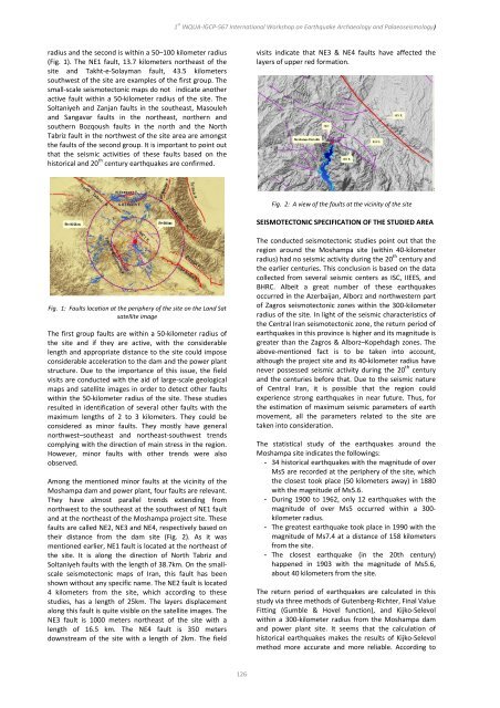
Among <strong>the</strong> mentioned m<strong>in</strong>or faults at <strong>the</strong> vic<strong>in</strong>ity of <strong>the</strong><br />
Moshampa dam <strong>and</strong> power plant, four faults are relevant.<br />
They have almost parallel trends extend<strong>in</strong>g from<br />
northwest to <strong>the</strong> sou<strong>the</strong>ast at <strong>the</strong> southwest of NE1 fault<br />
<strong>and</strong> at <strong>the</strong> nor<strong>the</strong>ast of <strong>the</strong> Moshampa project site. These<br />
faults are called NE2, NE3 <strong>and</strong> NE4, respectively based on<br />
<strong>the</strong>ir distance from <strong>the</strong> dam site (Fig. 2). As it was<br />
mentioned earlier, NE1 fault is located at <strong>the</strong> nor<strong>the</strong>ast of<br />
<strong>the</strong> site. It is along <strong>the</strong> direction of North Tabriz <strong>and</strong><br />
Soltaniyeh faults with <strong>the</strong> length of 38.7km. On <strong>the</strong> small‐<br />
scale seismotectonic maps of Iran, this fault has been<br />
shown without any specific name. The NE2 fault is located<br />
4 kilometers from <strong>the</strong> site, which accord<strong>in</strong>g to <strong>the</strong>se<br />
studies, has a length of 25km. The layers displacement<br />
along this fault is quite visible on <strong>the</strong> satellite images. The<br />
NE3 fault is 1000 meters nor<strong>the</strong>ast of <strong>the</strong> site with a<br />
length of 16.5 km. The NE4 fault is 350 meters<br />
downstream of <strong>the</strong> site with a length of 2km. The field<br />
1 st INQUA‐IGCP‐567 International Workshop on Earthquake Archaeology <strong>and</strong> <strong>Palaeoseismology</strong>)<br />
126<br />
visits <strong>in</strong>dicate that NE3 & NE4 faults have affected <strong>the</strong><br />
layers of upper red formation.<br />
Fig. 2: A view of <strong>the</strong> faults at <strong>the</strong> vic<strong>in</strong>ity of <strong>the</strong> site<br />
SEISMOTECTONIC SPECIFICATION OF THE STUDIED AREA<br />
The conducted seismotectonic studies po<strong>in</strong>t out that <strong>the</strong><br />
region around <strong>the</strong> Moshampa site (with<strong>in</strong> 40‐kilometer<br />
radius) had no seismic activity dur<strong>in</strong>g <strong>the</strong> 20 th century <strong>and</strong><br />
<strong>the</strong> earlier centuries. This conclusion is based on <strong>the</strong> data<br />
collected from several seismic centers as ISC, IIEES, <strong>and</strong><br />
BHRC. Albeit a great number of <strong>the</strong>se earthquakes<br />
occurred <strong>in</strong> <strong>the</strong> Azerbaijan, Alborz <strong>and</strong> northwestern part<br />
of Zagros seismotectonic zones with<strong>in</strong> <strong>the</strong> 300‐kilometer<br />
radius of <strong>the</strong> site. In light of <strong>the</strong> seismic characteristics of<br />
<strong>the</strong> Central Iran seismotectonic zone, <strong>the</strong> return period of<br />
earthquakes <strong>in</strong> this prov<strong>in</strong>ce is higher <strong>and</strong> its magnitude is<br />
greater than <strong>the</strong> Zagros & Alborz–Kopehdagh zones. The<br />
above‐mentioned fact is to be taken <strong>in</strong>to account,<br />
although <strong>the</strong> project site <strong>and</strong> its 40‐kilometer radius have<br />
never possessed seismic activity dur<strong>in</strong>g <strong>the</strong> 20 th century<br />
<strong>and</strong> <strong>the</strong> centuries before that. Due to <strong>the</strong> seismic nature<br />
of Central Iran, it is possible that <strong>the</strong> region could<br />
experience strong earthquakes <strong>in</strong> near future. Thus, for<br />
<strong>the</strong> estimation of maximum seismic parameters of earth<br />
movement, all <strong>the</strong> parameters related to <strong>the</strong> site are<br />
taken <strong>in</strong>to consideration.<br />
The statistical study of <strong>the</strong> earthquakes around <strong>the</strong><br />
Moshampa site <strong>in</strong>dicates <strong>the</strong> follow<strong>in</strong>gs:<br />
- 34 historical earthquakes with <strong>the</strong> magnitude of over<br />
Ms5 are recorded at <strong>the</strong> periphery of <strong>the</strong> site, which<br />
<strong>the</strong> closest took place (50 kilometers away) <strong>in</strong> 1880<br />
with <strong>the</strong> magnitude of Ms5.6.<br />
- Dur<strong>in</strong>g 1900 to 1962, only 12 earthquakes with <strong>the</strong><br />
magnitude of over Ms5 occurred with<strong>in</strong> a 300‐<br />
kilometer radius.<br />
- The greatest earthquake took place <strong>in</strong> 1990 with <strong>the</strong><br />
magnitude of Ms7.4 at a distance of 158 kilometers<br />
from <strong>the</strong> site.<br />
- The closest earthquake (<strong>in</strong> <strong>the</strong> 20th century)<br />
happened <strong>in</strong> 1903 with <strong>the</strong> magnitude of Ms5.6,<br />
about 40 kilometers from <strong>the</strong> site.<br />
The return period of earthquakes are calculated <strong>in</strong> this<br />
study via three methods of Gutenberg‐Richter, F<strong>in</strong>al Value<br />
Fitt<strong>in</strong>g (Gumble & Hovel function), <strong>and</strong> Kijko‐Selevol<br />
with<strong>in</strong> a 300‐kilometer radius from <strong>the</strong> Moshampa dam<br />
<strong>and</strong> power plant site. It seems that <strong>the</strong> calculation of<br />
historical earthquakes makes <strong>the</strong> results of Kijko‐Selevol<br />
method more accurate <strong>and</strong> more reliable. Accord<strong>in</strong>g to
