This environmental impact assessment for Kriegers flak ... - Vattenfall
This environmental impact assessment for Kriegers flak ... - Vattenfall
This environmental impact assessment for Kriegers flak ... - Vattenfall

You also want an ePaper? Increase the reach of your titles
YUMPU automatically turns print PDFs into web optimized ePapers that Google loves.
114 PRESENTATION OF THE AREA<br />
to present legislation these Þ shermen are not entitled<br />
to any compensation, but Swedish Offshore plans to<br />
compensate the Þ shermen <strong>for</strong> the potential economic<br />
damage caused by the farm. Negotiation regarding economic<br />
compensation is in progress.<br />
11.12 Leisure fi shing<br />
<strong>Kriegers</strong> Flak was earlier known to house large cod.<br />
Within the area, anglers were using rods and regular<br />
Þ shing trips were organised. These trips were offered<br />
during three months a year (when the large cod assembled)<br />
and during this period a maximum of two to<br />
three trips a week were organised.<br />
As the large cod in the area has declined in numbers,<br />
leisure Þ shing has more or less come to an end.<br />
Nowadays only sporadic anglers/organised Þ shing<br />
trips occur during the months of May and June.<br />
11.13 Recreation<br />
The area is during the summer months passed by<br />
leisure boats. None of these stay <strong>for</strong> any length of time<br />
in the area.<br />
11.14 The Interests of the Armed<br />
Forces<br />
In the area south of the Swedish south cost, the Forces<br />
are engaged in reconnaissance and intelligence activities.<br />
<strong>This</strong> is mainly done by monitoring using radar and<br />
communication intelligence equipment.<br />
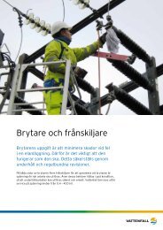
11.15 Cables<br />
A telecommunication cable named GS2 crosses the<br />
area. The cable is however not in use.<br />
Another cable has been identiÞ ed but since it is situated<br />
in the outskirts of the area, it will not have to be<br />
crossed.<br />
Marin Mätteknik has during their investigations<br />
discovered traces of something which is either a cable<br />
or a trawling track. If it is a cable, it is likely to be the<br />
above mentioned GS2 cable. The coordinates do not<br />
entirely match the in<strong>for</strong>mation about the GS2, but it is<br />
usual that this type of in<strong>for</strong>mation has a certain margin<br />
of error.<br />
For further in<strong>for</strong>mation about these cables, see Appendix<br />
4.5.<br />
Two different cables that are no longer in use cross<br />
the area.<br />
The DONG company has plans to lay a gas pipeline<br />
across the Baltic. Two different alternative routes have<br />
been suggested and one of these could have an <strong>impact</strong><br />
on the north-eastern parts of the farm (see picture<br />
below).<br />
Alternative routes <strong>for</strong> gas pipeline, DONG