This environmental impact assessment for Kriegers flak ... - Vattenfall
This environmental impact assessment for Kriegers flak ... - Vattenfall
This environmental impact assessment for Kriegers flak ... - Vattenfall

Create successful ePaper yourself
Turn your PDF publications into a flip-book with our unique Google optimized e-Paper software.
46 ALTERNATIVE LOCATIONS<br />
j) Commercial fi shing and navigation<br />
When considering if an area is appropriate, the Þ shing<br />
industry and shipping/navigation is taken into account.<br />
The development should not hinder important Þ shing<br />
and it should not be in the vicinity of busy shipping<br />
lanes as this can create a safety risk.<br />
k) Miscellaneous<br />
There can also be other factors that are important to<br />
consider. These are accounted <strong>for</strong> under Miscellaneous.<br />
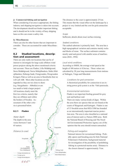
8.2 Studied locations, description<br />
and <strong>assessment</strong><br />
There are only really ten locations that can be of<br />
interest to investigate <strong>for</strong> large scale offshore wind<br />
power projects taking the above mentioned criteria<br />
into account. These are Fladen, Lilla Middelgrund,<br />
Stora Middelgrund, Norra Midsjöbanken, Södra Midsjöbanken,<br />
Hoburgs bank, Finngrunden, Persgrunden<br />
<strong>Kriegers</strong> Flak as well as an area in Stockholm that we<br />
will call ABI. Most other locations are disregarded<br />
as they are too close to shore<br />
(e.g. Smygehamn – Abbekås) or are<br />
too small to hold a larger project.<br />
All locations clearly meet the<br />
Þ rst two criteria, namely that<br />
they are offshore and within<br />
the borders of Sweden. Assessment<br />
of the other criteria<br />
is presented below.<br />
8.2.1 Fladen<br />
Water depth<br />
The depth in the area<br />
varies between 5 and<br />
65 meters.<br />
Distance to coast<br />
The distance to the coast is approximately 25 km.<br />
<strong>This</strong> means that the visual effect on the landscape by a<br />
project is very limited and the cost <strong>for</strong> grid connection<br />
acceptable.<br />
Scope<br />
SufÞ cient, details about exact surface missing.<br />
Seabed conditions<br />
The seabed substrate is primarily hard. The area has a<br />
high topographical variation and contains mainly rocks<br />
and blocks of stone. The surface sediment contains<br />
mostly sand and gravel with smaller areas of mud/moraine<br />
(SGU, 1994)<br />
Local wind conditions<br />
According to SMHI, the average wind speed at the<br />
height of 100 meters is 9,5m/sec. These values are<br />
calculated by 20 year long measurements from stations<br />
at Nidingen, Vinga and Måseskär.<br />
Conditions <strong>for</strong> grid connection<br />
A theoretical possibility <strong>for</strong> connection to an existing<br />
power grid system is at the Värö peninsula.<br />
Environmental restrictions<br />
Fladen is an important feeding ground <strong>for</strong> grey<br />
seal and harbour seal.<br />
There are many various kinds of algae. Within<br />
the area there are species that are not found at the<br />
coasts of Skagerack and Kattegatt. Fladen is one<br />
of 13 Swedish areas that HELCOM has branded<br />
as an internationally important marine protection<br />
area. The area is also classiÞ ed as a national<br />
area of interest and is a Natura 2000-area. Both<br />
the National Board of Housing and The Swedish<br />
Environmental Protection Agency are of the<br />
opinion that the area should remain untouched.<br />
Fishing and navigation<br />
National interest <strong>for</strong> recreational Þ shing. Probably<br />
spawn and breeding area <strong>for</strong> Þ sh (National<br />
Fisherman’s Federation, background material<br />
<strong>for</strong> investigation of the possibility of prohibiting<br />
Þ shing in a protected marine area). Distance to<br />
the closest channel is approximately 5 km.