This environmental impact assessment for Kriegers flak ... - Vattenfall
This environmental impact assessment for Kriegers flak ... - Vattenfall
This environmental impact assessment for Kriegers flak ... - Vattenfall

Create successful ePaper yourself
Turn your PDF publications into a flip-book with our unique Google optimized e-Paper software.
70 PRESENTATION OF THE AREA<br />
1995). During normal winter storms the water level in<br />
Kattegat increases and, in comparison to the southern<br />
Baltic, there will be a height difference of ca 1 metre.<br />
<strong>This</strong> increased water level generates a greater inß ow<br />
of salt water from Kattegat via Öresund, increasing the<br />
Correlation between wind speed and current flow speed<br />
salination level in the Baltic. Periods of Þ ve to ten days<br />
of storm will also increase saltwater currents through<br />
the Bælts <strong>for</strong> the same reason.<br />
With a frequency of three years or more, large<br />
additions of salty water occur caused by prolonged<br />
winter storms preceded by periods of high pressure,<br />
<strong>for</strong>cing water from the Baltic, thus lowering the water<br />
level considerably. <strong>This</strong> prolonged inß ow means that<br />
the Belt sea front, where the bracken water mixes with<br />
the salty sea water, is shifted <strong>for</strong>ward to the Darss<br />
threshold. <strong>This</strong> makes it possible <strong>for</strong> a mixed water<br />
plume with a salinity of at least 17 PSU to move into<br />
the Arcona basin and later Þ ll up the other basins with<br />
heavy and oxygen rich water. These large additions of<br />
salty water are less frequent, resulting in a shortage of<br />
oxygen in the deep basins of theBaltic.<br />
11.2.2 Salinity, temperature and oxygen<br />
content<br />
The area at and around <strong>Kriegers</strong> Flak is hydrologically<br />
well documented. SMHI has since 1958 a measuring<br />
station in the Arcona basin east of <strong>Kriegers</strong> Flak measuring<br />
temperature, salination and oxygen content once<br />
or twice a month at each Þ ve metre interval from the<br />
surface down to a depth of 45 m (BY2). <strong>This</strong> measuring<br />
series can be downloaded from www.smhi.se.<br />
IOW in Rostock is working on a model <strong>for</strong> the salt<br />
level balance of the entire Baltic, taking into account<br />
the cumulative effects of establishing a number of<br />
offshore wind farms. Results should be known during<br />
2005.<br />
On behalf of the Group, the water conditions around<br />
<strong>Kriegers</strong> Flak have been researched continuously by<br />
IfAÖ during 2002-2003. <strong>This</strong> was carried out simultaneously<br />
with other water related <strong>environmental</strong><br />
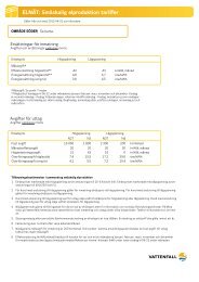
Hydrographical data (median values +/- SD) during the three fishing campaigns in the test area in 2003<br />
Spring 2002<br />
Salt content<br />
[PSU]<br />
Water temperature<br />
[C°]<br />
Oxygen content<br />
[mg/l] [% fullness]<br />
Surface Seabed Surface Seabed Surface Seabed Surface Seabed<br />
Median values 7,6 7,9 15,6 13,9 9,1 8,6 91,5 83,1<br />
Standard deviation 0,2 0,6 0,3 1,3 0,2 0,2 1,9 1,9<br />
Differens surface/seabed<br />
Measurements: n=10<br />
-0,3 1,7 0,5 8,3<br />
cont. next page