

(PESIA) Weg naar Zee 2D Seismic - Staatsolie
(PESIA) Weg naar Zee 2D Seismic - Staatsolie
(PESIA) Weg naar Zee 2D Seismic - Staatsolie

Create successful ePaper yourself
Turn your PDF publications into a flip-book with our unique Google optimized e-Paper software.
P-all consultants<br />
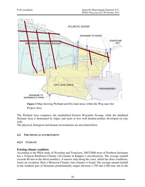
Figure 3 Map p showing Wetland and Dry land areas within the <strong>Weg</strong> <strong>naar</strong> <strong>Zee</strong><br />
Project Area<br />
The Wetland Area comprises the uninhabited Eastern Wayambo Swamp, while the inhabited<br />
Dryland Area is dominated by ridges and more or less well drained polders developed on clay<br />
soils.<br />
The physical, biological and human environments are described below.<br />
4.2 THE HE PHYSICAL ENVIRONM<br />
ENVIRONMENT<br />
4.2.1 CLIMATE<br />
<strong>Staatsolie</strong> Maatschappij Suriname N.V.<br />
<strong>PESIA</strong> <strong>Weg</strong> <strong>naar</strong> <strong>Zee</strong> <strong>2D</strong> <strong>Seismic</strong> 2012<br />
Existing climate condition<br />
According to the PEIA study of Noordam and Teunissen, 2007/2008 most of Northern Suriname<br />
has a Tropical Rainforest Climate (Af (Af-climate climate in Köppen’s classification). The average rainfall<br />
exceeds 60 mm in the driest month(s). A narrow strip along the coast, which has drier conditions,<br />
forms an exception. Here a Monsoon Climate (Am (Am-climate) is found. The average annual rainfall<br />
in the northern part of Suriname predominantly ranges between 1,750 and 2,500 mm, but in the<br />
34


