

(PESIA) Weg naar Zee 2D Seismic - Staatsolie
(PESIA) Weg naar Zee 2D Seismic - Staatsolie
(PESIA) Weg naar Zee 2D Seismic - Staatsolie

You also want an ePaper? Increase the reach of your titles
YUMPU automatically turns print PDFs into web optimized ePapers that Google loves.
P-all consultants<br />
4.2.6 GEOMORPHOLOGY EOMORPHOLOGY AND SOI SOILS<br />
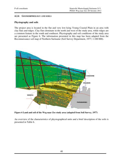
Physiography and soils<br />
<strong>Staatsolie</strong> Maatschappij Suriname N.V.<br />
<strong>PESIA</strong> <strong>Weg</strong> <strong>naar</strong> <strong>Zee</strong> <strong>2D</strong> <strong>Seismic</strong> 2012<br />
The project area is located in the flat and very low low-lying lying Young Coastal Plain in an area with<br />
clay flats and ridges. Clay flats dominate in the north and west of the study area, while ridges are<br />
a common feature in the south and southeast. Physiography and soil conditions of the study area<br />
are presented as Figure 6. The information presented in this map has been adapted from the<br />
Reconnaissance soil map of Northern Suriname (Soil Survey Department, 1977; 1:100 000).<br />
Figure 6 Land and soil of the <strong>Weg</strong> <strong>naar</strong> <strong>Zee</strong> study area (adapted from Soil Survey, 1977)<br />
An overview of the characteristics of physiographical units and a brief description of the soils is<br />
presented in Table 6.<br />
40


