

(PESIA) Weg naar Zee 2D Seismic - Staatsolie
(PESIA) Weg naar Zee 2D Seismic - Staatsolie
(PESIA) Weg naar Zee 2D Seismic - Staatsolie

You also want an ePaper? Increase the reach of your titles
YUMPU automatically turns print PDFs into web optimized ePapers that Google loves.
P-all consultants<br />
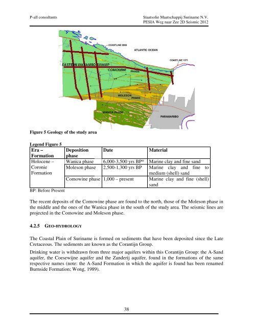
Figure 5 Geology of the study area<br />
Legend Figure 5<br />
Era – Deposition Date Material<br />
Formation phase<br />
Holocene – Wanica phase 6,000-3,500 yrs BP* Marine clay and fine sand<br />
Coronie Moleson phase 2,500-1,300 yrs BP Marine clay and fine to<br />
Formation<br />
medium (shell) sand<br />
Comowine phase 1,000 – present Marine clay and fine (shell)<br />
sand<br />
BP: Before Present<br />
The recent deposits of the Comowine phase are found to the north, those of the Moleson phase in<br />
the middle and the ones of the Wanica phase in the south of the study area. The seismic lines are<br />
projected in the Comowine and Moleson phase.<br />
4.2.5 GEO-HYDROLOGY<br />
<strong>Staatsolie</strong> Maatschappij Suriname N.V.<br />
<strong>PESIA</strong> <strong>Weg</strong> <strong>naar</strong> <strong>Zee</strong> <strong>2D</strong> <strong>Seismic</strong> 2012<br />
The Coastal Plain of Suriname is formed on sediments that have been deposited since the Late<br />
Cretaceous. The sediments are known as the Corantijn Group.<br />
Drinking water is withdrawn from three major aquifers within this Corantijn Group: the AA-Sand<br />
A<br />
aquifer, the Coesewijne aquifer and the Zanderij aquifer, found in the formations of th the th same<br />
respective names (note: the A-Sand Sand Formation in which the aquifer is found has been renamed<br />
Burnside Formation; Wong, 1989).<br />
38


