Complete report - Partners for Clean Streams
Complete report - Partners for Clean Streams
Complete report - Partners for Clean Streams

You also want an ePaper? Increase the reach of your titles
YUMPU automatically turns print PDFs into web optimized ePapers that Google loves.
DNR<br />
Collaborator(s):<br />
Maumee RAP Urban Runoff Action Group, Toledo-Lucas<br />
County Plan Commissions, University of Toledo, BGSU,<br />
Wood SWCD, Lucas SWCD, Ohio EPA<br />
Signage & Native Plantings along the Swan Creek RiverWalk<br />
Educational signs were placed along the Swan Creek RiverWalk in Downtown Toledo.<br />
Signs highlighted native plantings and facts about the Swan Creek watershed. Plants<br />
native to the Swan Creek watershed were planted along the creek bank and walking<br />
trail. (see Swan Creek RiverWalk <strong>for</strong> more details)<br />
Lead Organization:<br />
Maumee RAP Swan Creek Action Group, Maumee RAP Open<br />
Space & Wetlands Action Group, City of Toledo DNR<br />
“Impact on Urban <strong>Streams</strong> through Land Use Practices” Workshop (Sept. 1999)<br />
Workshop targeting zoning commissions, developers, commercial realtors, and<br />
politicians to increase awareness of how local land use decisions affect water quality.<br />
The goal of this event was <strong>for</strong> increased communication and coordination by local<br />
officials with the Lucas SWCD.<br />
Lead Organization:<br />
Collaborator(s):<br />
USDA National Resources Conservation Service (NRCS)<br />
Maumee RAP Urban Runoff Action Group, Lucas SWCD,<br />
Toledo-Lucas County Plan Commissions, TMACOG, local<br />
realtors, Home Builders Association, Storm Water Policy<br />
Board, Lucas County Engineers Office, University of Toledo,<br />
BGSU, Owens Community College<br />
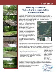
Ottawa River Interpretive Trail<br />
1999-2000<br />
Description:<br />
As a part of the permit requirements <strong>for</strong> the DaimlerChrysler Jeep Expansion Project,<br />
the City of Toledo agreed to construct an interpretive walkway along the Ottawa River<br />
adjacent to the City owned Hoffman Road Landfill. During the public comment period<br />
<strong>for</strong> the 401 permit, it was suggested that a local project be part of the mitigation plan.<br />
The idea <strong>for</strong> an interpretive trail along the Ottawa River was presented by the<br />
Maumee RAP, realizing it would provide a unique opportunity <strong>for</strong> both pedestrian and<br />
wheelchair traffic.<br />
The trailhead has an asphalt parking lot suitable <strong>for</strong> up to two buses. The 1500 foot<br />
trail follows a treeline along the Ottawa River and vegetated surface of the Hoffman<br />
Road Landfill. A fence separates the trail from the other areas of the landfill. The<br />
Maumee RAP assisted with developing the text <strong>for</strong> the educational signs along the<br />
walkway which discuss wetlands, the landfill, and in<strong>for</strong>mation about the Ottawa River<br />
watershed. The trail proceeds around a constructed wetland sedimentation basin and<br />
leads to a boardwalk where the grade near the Ottawa River steepens. There is also<br />
an overlook plat<strong>for</strong>m at the edge of the Ottawa River.<br />
Lead Organization:<br />
Collaborator(s):<br />
City of Toledo<br />
Maumee RAP Open Space and Wetlands Action Group, Maumee RAP Ottawa River<br />
Activities and Accomplishments<br />
in the Maumee Area of Concern<br />
174<br />
Issue 5: Increase Public<br />
Participation and Awareness