Complete report - Partners for Clean Streams
Complete report - Partners for Clean Streams
Complete report - Partners for Clean Streams

You also want an ePaper? Increase the reach of your titles
YUMPU automatically turns print PDFs into web optimized ePapers that Google loves.
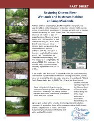
Duck Creek. This property was <strong>for</strong>merly an industrial facility which produced asphalt<br />
shingle. The SEP is also expected to fund aerial photographs and topographic<br />
mapping of Duck and Otter Creeks, analysis of potential properties <strong>for</strong> additional<br />
wetland creation, environmental studies, engineering design, wetland<br />
restoration/construction, and the creation of public access areas and overlooks.<br />
Lead Organization:<br />
Collaborator(s):<br />
City of Toledo, Toledo-Lucas County Port Authority (funded as<br />
a Supplemental Environmental Project to an US EPA<br />
en<strong>for</strong>cement case)<br />
Duck and Otter Creek <strong>Partners</strong>hip, Inc., City of Toledo<br />
Status and Trends in Suspended-Sediment Discharges,<br />
Soil Erosion, and Conservation Tillage in the Maumee River Basin<br />
1998-1999<br />
Description:<br />
As part of a national study of trends in surface and ground water quality, the US<br />
Geological Survey (USGS) completed a five-year, $6.7 million study of the western<br />
drainage basin of Lake Erie, including the Maumee AOC. The objective of this ef<strong>for</strong>t<br />
was to achieve a comprehensive understanding of the effects of nutrients and<br />
agricultural/industrial chemicals. This study will help promote prudent decisionmaking<br />
regarding restorative ef<strong>for</strong>ts in the Maumee AOC. The study compared the<br />
relationship between suspended-sediment discharges and conservation-tillage<br />
practices and looked at the total soil loss <strong>for</strong> the Maumee River basin in Ohio,<br />
Michigan, and Indiana. This study worked on the premise that soil erosion caused<br />
suspended-sediment discharges to the Maumee River and, in turn, suspendedsediments<br />
in Lake Erie. The major human and natural factors to suspended –<br />
sediment discharges are soil drainage, runoff potential, stream slope, and agricultural<br />
land use.<br />
The study concluded with the following in<strong>for</strong>mation:<br />
Tiffin/St. Joseph<br />
Rivers<br />
Auglaize/St.<br />
Mary’s Rivers<br />
Soil Quality Moderately/somewhat<br />
poorly drained<br />
Poorly/very poorly<br />
drained<br />
Runoff Potential Moderate High<br />
Basin Area 29.0% 48.7%<br />
Average-annual<br />
30.7% 53.5%<br />
streamflow<br />
Average annual<br />
suspended-sediment<br />
discharge<br />
9.31% 46.5%<br />
From 1993-1998, 55.4% of all crop fields along the Maumee River Basin used<br />
conservation methods of tilling. The increase in conservation tillage corresponds with<br />
a decrease in suspended-sediment discharge over time. The long term goal of the<br />
United States ACOE is to reduce sediment dredged from the Maumee River/Maumee<br />
Bay by 15%.<br />
Lead Organization:<br />
USGS, US ACOE, USDA-NRCS<br />
Activities and Accomplishments<br />
in the Maumee Area of Concern<br />
236<br />
Issue 23: Long Term<br />
Monitoring of the AOC