- Page 4:
SOUL CObJSERVATION PEOPLE, RELIGION
- Page 8 and 9:
with " Generous sod", Dennis displa
- Page 10 and 11:
Stewardship - What Is It? Stewartls
- Page 12 and 13:
the earth's resources. However, it
- Page 14 and 15:
Certainly the earth and thus man, w
- Page 16 and 17:
That each Church set up a commissio
- Page 18 and 19:
LET THE RED VAN SPEAK In 1854 "the
- Page 20 and 21:
WHAT SHOULD WE TEACH What must the
- Page 22 and 23:
established a dualism of man and na
- Page 24 and 25:
R IBLIOGRAPHY Anonymous. 1985. Stat
- Page 30:
PREFACE : This paper has been writt
- Page 33 and 34:
vital supplies. The once-heroic pio
- Page 35 and 36:
to land use decision-making which t
- Page 37 and 38:
a approach for Australia. The dange
- Page 39 and 40:
As Ashby points out past experience
- Page 41 and 42:
exclusive right to use the land, ne
- Page 43 and 44:
matter. They certainly don't do tha
- Page 45 and 46:
a constraint on our freedom of acti
- Page 47 and 48:
and every individual creature and t
- Page 49 and 50:
Christians was noted. Both display
- Page 51 and 52:
Nature's Harmonies'. As David Lowen
- Page 53 and 54:
key phrases in Genesis are: "Have d
- Page 55 and 56:
Can Values and ~thics be Taught? Pl
- Page 57 and 58:
"The university's job may not be th
- Page 59 and 60:
coming generations. The list below
- Page 61 and 62:
National goals should change as pro
- Page 63 and 64:
indicators can continue to progress
- Page 65 and 66:
the problems of the present. It sho
- Page 67 and 68:
Cook, E. 1970. Environmental Ethics
- Page 69:
Santmire, H. P. 1970. Brother Earth
- Page 73 and 74:
--- - - - - - I. ORGANISATION AND I
- Page 75 and 76:
7' - - F a - - present parties, hav
- Page 77 and 78:
5. Res~onsibilitv of Faculties of A
- Page 79 and 80:
A -- 15. Role of Urban-Based conser
- Page 81:
FEDERAL STATE LOCAL EDUCATION l N C
- Page 87 and 88:
- - --< -- - I. ORGANISATION AND IN
- Page 89 and 90:
present parties, have failed to con
- Page 91 and 92:
Responsibilitv of Faculties of Agri
- Page 93 and 94:
15. Role of Urban-Based Conservatio
- Page 95:
FEDERAL STATE LOCAL EXTENSION LANDH
- Page 102 and 103:
government. In this way the long-st
- Page 104 and 105:
on a permanent basis. 8. -Role -- -
- Page 106 and 107:
%==. 10. Wider Use of Group Methods
- Page 108:
N0113V UOJ S31V3S3Lnlll QNV S13A31
- Page 113 and 114:
11. In Queensland, about 40% of nat
- Page 118 and 119:
Earth Garden, May 1 986 speak or th
- Page 120 and 121:
combines very small holdings with s
- Page 122 and 123:
The stages of cultural and ecologic
- Page 124 and 125:
The role of trees in controlling so
- Page 126 and 127:
proportions,. - _ 6. We must bring-
- Page 130 and 131:
an Land Degrad By Brian Roberts The
- Page 132 and 133:
principles ror de~elopment In \uch
- Page 134:
Exposed clay subsoil following seve
- Page 139 and 140:
evide~~c-to indicate that this situ
- Page 141 and 142:
the field and the proportion of exi
- Page 146 and 147:
A.I.A.S. Symp. 20/10/89 EFFECTIVE G
- Page 148 and 149:
These figures exclude the contribut
- Page 150 and 151:
these four requirements are met, th
- Page 152 and 153:
the association of the group with a
- Page 154 and 155:
A rational analysis should be made
- Page 156:
REFERENCES Anonymous. (1978). Basis
- Page 159 and 160:
APPENDIX 2 ELEMENTS OF A SHIRE LAND
- Page 164 and 165:
' I a -I how T'S NEW IN LAND C CTS
- Page 166:
and tresspassers, rather than as cr
- Page 171 and 172:
The Present Position . - - - ~r&e&t
- Page 173 and 174:
on Objectives - - -- - - ----=:I .
- Page 175 and 176:
APPENDIX 2 * 1. clear goals which a
- Page 177 and 178:
.A- 7. Planninq -- - -,sip - proble
- Page 182 and 183:
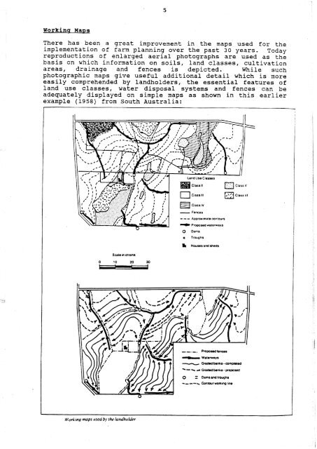
Brian Roberts, DDIAE 1989 Farm plan
- Page 184 and 185:
farm plan or major changes in physi
- Page 188 and 189:
Cover Story LAND STE ARDSH udes Tow
- Page 190 and 191:
individual's rights. No individual
- Page 192 and 193: B R Roberts Darling Downs Institute
- Page 194 and 195: attention at an early date. Advisor
- Page 196: TABLE 1 1 LE AGRICULTURE 1. LAND CA
- Page 201 and 202: th~should be ol t1[;11 c.onc-crn to
- Page 203 and 204: which could form the cornerstone of
- Page 208 and 209: CLEARING: WHO SHOULD DECIDE? Brian
- Page 210 and 211: . Who has the knowledge and informa
- Page 214 and 215: Range Monitoring Workshop Nat. S.C.
- Page 216 and 217: Because most of the pastoral zone i
- Page 218 and 219: FIGURE 1 iabifity ratings for Austr
- Page 220 and 221: environment as distinct from the ef
- Page 222 and 223: will be referred to later. It is de
- Page 224 and 225: ~ield workers are agreed that the i
- Page 226 and 227: consumed in good and poor seasons r
- Page 228 and 229: sufficiently to meet the criteria a
- Page 230: Roberts, B. (1986). Proc. Sec. Int.
- Page 235: The second reality is that in some
- Page 239 and 240: choices of cultivation practices ar
- Page 241: For those roads that are parallel t