

Europe - UNEP
Europe - UNEP
Europe - UNEP

You also want an ePaper? Increase the reach of your titles
YUMPU automatically turns print PDFs into web optimized ePapers that Google loves.
SOCIOECONOMIC AND GEOPOLITICAL PARAMETERS<br />
A<br />
B<br />
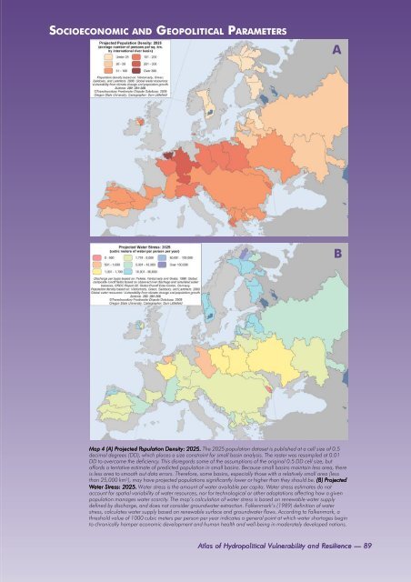
Map 4 (A) Projected Population Density: 2025. The 2025 population dataset is published at a cell size of 0.5<br />
decimal degrees (DD), which places a size constraint for small basin analysis. The raster was resampled at 0.01<br />
DD to overcome the deficiency. This disregards some of the assumptions of the original 0.5 DD cell size, but<br />
affords a tentative estimate of predicted population in small basins. Because small basins maintain less area, there<br />
is less area to smooth out data errors. Therefore, some basins, especially those with a relatively small area (less<br />
than 25,000 km 2 ), may have projected populations significantly lower or higher than they should be. (B) Projected<br />
Water Stress: 2025. Water stress is the amount of water available per capita. Water stress estimates do not<br />
account for spatial variability of water resources, nor for technological or other adaptations affecting how a given<br />
population manages water scarcity. The map’s calculation of water stress is based on renewable water supply<br />
defined by discharge, and does not consider groundwater extraction. Falkenmark’s (1989) definition of water<br />
stress, calculates water supply based on renewable surface and groundwater flows. According to Falkenmark, a<br />
threshold value of 1000 cubic meters per person per year indicates a general point at which water shortages begin<br />
to chronically hamper economic development and human health and well-being in moderately developed nations.<br />
Atlas of Hydropolitical Vulnerability and Resilience — 89


