- Page 1:
Pennsylvania Rivers Conservation Pr
- Page 4 and 5:
land to development. Strong communi
- Page 6 and 7:
Human resources available to facili
- Page 8 and 9:
other communities, organizations, a
- Page 11 and 12:
TABLE OF CONTENTS List of Figures .
- Page 13 and 14:
8.3 Sustainable Development and Gov
- Page 15 and 16:
Figure 5.14. Average summer phospho
- Page 17 and 18:
Figure 10.3. Management Areas propo
- Page 19:
ACKNOWLEDGMENTS AND PLAN AUTHORSHIP
- Page 22 and 23:
working with interested teacher and
- Page 24 and 25:
Figure 1.3. Perceived importance of
- Page 26 and 27:
1.3 Watershed Plan Focus The primar
- Page 28 and 29:
Figure 2.2. Detail of the south-cen
- Page 30 and 31:
Figure 2.4. Physiographic provinces
- Page 32 and 33:
westward. Although the paucity of f
- Page 34 and 35:
via the Erigan River, a major river
- Page 36 and 37:
Warren and Whittlesey can be found
- Page 38 and 39:
evised paleoenvironmental picture,
- Page 40 and 41:
characteristic ground stone tools,
- Page 42 and 43:
phase represent the most common Lat
- Page 44 and 45:
including flexed and extended inhum
- Page 46 and 47:
with the appearance of European tra
- Page 48 and 49:
The Commonwealth of Pennsylvania wa
- Page 50 and 51:
of $800 for the purchase of The Tri
- Page 52 and 53:
In addition to these townships, the
- Page 54 and 55:
Pittsburgh Railroad had reached New
- Page 56 and 57:
Figure 3.3. Density of registered a
- Page 58:
the Whittlesey and Warren III stran
- Page 61 and 62:
Table 3.3. Properties in the Study
- Page 63 and 64:
Table 3.3—continued Name Address
- Page 65 and 66:
Table 3.3—continued Name Address
- Page 67 and 68:
"Little Ice Age"), and the validity
- Page 69 and 70:
"massasaugies" (Eastern Massasauga
- Page 71 and 72:
eport (Col. John Fleeharty) lamente
- Page 73 and 74:
flowing streams. The starting point
- Page 75 and 76:
elow the park." Apparently the pump
- Page 77 and 78:
A submerged arching sand feature is
- Page 79 and 80:
of the lake plain and upland areas
- Page 81 and 82:
characteristics, and are important
- Page 83 and 84:
Lake section (see Figure 2.4). Nota
- Page 85 and 86:
Figure 5.2. Flow time series for Tw
- Page 87 and 88:
Figure 5.4. Flow time series for Co
- Page 89 and 90:
Figure 5.8. Flow per square mile pe
- Page 91 and 92:
area that have thicker glacial depo
- Page 93 and 94:
Table 5.4. Protected Water Uses for
- Page 95 and 96:
Stream Zone County 3—East Branch
- Page 97 and 98:
5.10.2 Permitted Discharges The two
- Page 99 and 100:
Figure 5.14. Average summer phospho
- Page 101 and 102:
Figure 5.15. Graphical analyses of
- Page 103 and 104:
Figure 5.17. Average summer nitrate
- Page 105 and 106:
Figure 5.19. Mercury concentrations
- Page 107 and 108:
Figure 5.20. Map showing locations
- Page 109 and 110:
Figure 5.22. Number of stream miles
- Page 111 and 112:
91 Figure 5.24. Results of Campbell
- Page 113 and 114:
Table 5.6. Range in Number of E. co
- Page 115 and 116:
Figure 5.26. Maximum E. coli counts
- Page 117 and 118:
The recent investigation completed
- Page 119 and 120:
Figure 5.30. Sources of known nondo
- Page 121 and 122:
6 NATURAL RESOURCES 6.1 Animal Life
- Page 123 and 124:
Rank Status Taxon Common Name Globa
- Page 125 and 126:
Table 6.2. Pennsylvania Vertebrate
- Page 127 and 128:
Table 6.3. Noted Occurrence of Spaw
- Page 129 and 130:
Figure 6.4. Water quality designati
- Page 131 and 132:
Figure 6.6. Fishing hours spent on
- Page 133 and 134:
Figure 6.7. Comparative analysis of
- Page 135 and 136: Figure 6.9. Percentage breakdown of
- Page 137 and 138: A small number of the birds listed
- Page 139 and 140: phytoplankton by Dreissena allows l
- Page 141 and 142: populations increase. Corbicula flu
- Page 143 and 144: Rank Status Taxon Common name Globa
- Page 145 and 146: Rank Status Taxon Common name Globa
- Page 147 and 148: Two other forest wetland plant comm
- Page 149 and 150: 6.2.4 Emergent Wetlands Over half o
- Page 151 and 152: alleghaniensis), sugar maple, red m
- Page 153 and 154: Table 6.6.Percentage Composition of
- Page 155 and 156: Figure 6.18. Detail of the largest
- Page 157 and 158: Figure 7.1. Responses made by study
- Page 159 and 160: Figure 7.3. Spatial distribution of
- Page 161 and 162: Presque Isle State Park is connecte
- Page 163 and 164: Table 7.2. Number of Recreational O
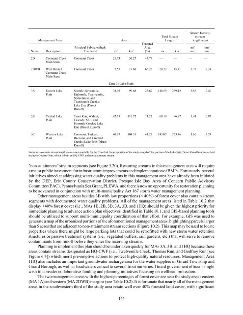
- Page 165 and 166: lakefront recreational properties,
- Page 167 and 168: Map Id Subwatershed Comment 51 41.5
- Page 169 and 170: Bayfront Center for Maritime Studie
- Page 171 and 172: Other watershed associations or wat
- Page 173 and 174: Figure 8.1. Child poverty rates in
- Page 175 and 176: comprehensive vision or plan, have
- Page 177 and 178: and municipalities should be encour
- Page 179 and 180: 5. In order to sustain maximum biod
- Page 181 and 182: 10 PRIORITIES AND STRATEGIES FOR AC
- Page 183 and 184: easements for riparian areas, and p
- Page 185: Table 10.2 Management Areas Defined
- Page 189 and 190: Figure 10.4. Example of how GIS can
- Page 191 and 192: Watershed Portion MAs Main Subwater
- Page 193 and 194: Restoration actions Management Area
- Page 195 and 196: 11 REFERENCES CITED Abrams, M. D. 2
- Page 197 and 198: Broyles, B. J. 1971 Second Prelimin
- Page 199 and 200: Cooper, N. L., J. R. Bidwell, and D
- Page 201 and 202: Dzurko, Robert 1972 Conneaut Creek
- Page 203 and 204: Goodyear, A. C. 1999 The Early Holo
- Page 205 and 206: Jasim, S. Y., A. Irabelli, L. Schwe
- Page 207 and 208: Leighton, R. 2006 Pennsylvania Fish
- Page 209 and 210: Michaels, A. 2005 Pennsylvania Has
- Page 211 and 212: 2007d Waterways, Wetlands, and Eros
- Page 213 and 214: Richardson, J. B., and J. B. Peters
- Page 215 and 216: Soon, W. and S. Baliunas 2003 Proxy
- Page 217 and 218: Tomikel and Shepps 1967 Trasande, L
- Page 219: Whitley, D. S., and R. I. Dorn 1993
- Page 223 and 224: Preparing For Watershed Conservatio
- Page 225 and 226: Introduction (cont’d) In March of
- Page 227 and 228: Executive Summary Overall, responde
- Page 229 and 230: Executive Summary (cont’d) Cont
- Page 231 and 232: Summary Of Key Groups (cont’d) Ur
- Page 233 and 234: Please Indicate Whether You Agree,
- Page 235 and 236: In Your Opinion, Is The Need For Im
- Page 237 and 238:
If You Had To Choose Between Proper
- Page 239 and 240:
Favorite Locations For Recreation I
- Page 241 and 242:
Favorite Motor Boating Locations To
- Page 243 and 244:
Favorite Hiking Locations Location
- Page 245 and 246:
Favorite Swimming Locations Total R
- Page 247 and 248:
Knowledge Of Historic And Prehistor
- Page 249:
Support For Stream Protection Measu
- Page 253 and 254:
LERC Rivers Conservation Plan Publi
- Page 255 and 256:
• Mason: As far as education, get
- Page 257:
• Kloss: Educate people about Act
- Page 261 and 262:
Great Lakes Commission http://www.g
- Page 263:
Center for Economic and Environment
- Page 267 and 268:
The Erie County portion of the Penn
- Page 269 and 270:
Feature Parameters Parameter Variab
- Page 271 and 272:
Feature Parameters Parameter Variab