

Watershed Conservation Plan - Destination Erie
Watershed Conservation Plan - Destination Erie
Watershed Conservation Plan - Destination Erie

Create successful ePaper yourself
Turn your PDF publications into a flip-book with our unique Google optimized e-Paper software.
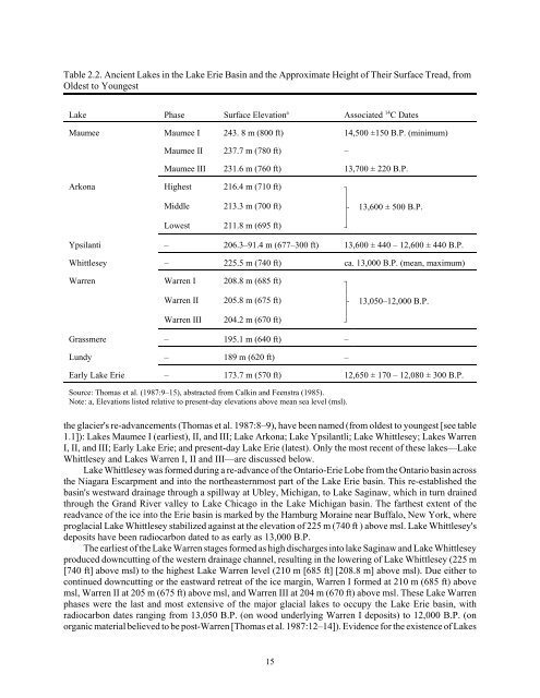
Table 2.2. Ancient Lakes in the Lake <strong>Erie</strong> Basin and the Approximate Height of Their Surface Tread, from<br />
Oldest to Youngest<br />
Lake Phase Surface Elevation a Associated 14 C Dates<br />
Maumee Maumee I 243. 8 m (800 ft) 14,500 ±150 B.P. (minimum)<br />
Maumee II 237.7 m (780 ft) –<br />
Maumee III 231.6 m (760 ft) 13,700 ± 220 B.P.<br />
Arkona Highest<br />
Middle<br />
Lowest<br />
216.4 m (710 ft)<br />
213.3 m (700 ft)<br />
211.8 m (695 ft)<br />
,<br />
*<br />
/<br />
*<br />
-<br />
13,600 ± 500 B.P.<br />
Ypsilanti – 206.3–91.4 m (677–300 ft) 13,600 ± 440 – 12,600 ± 440 B.P.<br />
Whittlesey – 225.5 m (740 ft) ca. 13,000 B.P. (mean, maximum)<br />
Warren Warren I<br />
Warren II<br />
Warren III<br />
208.8 m (685 ft)<br />
205.8 m (675 ft)<br />
204.2 m (670 ft)<br />
,<br />
*<br />
/<br />
*<br />
-<br />
13,050–12,000 B.P.<br />
Grassmere – 195.1 m (640 ft) –<br />
Lundy – 189 m (620 ft) –<br />
Early Lake <strong>Erie</strong> – 173.7 m (570 ft) 12,650 ± 170 – 12,080 ± 300 B.P.<br />
Source: Thomas et al. (1987:9–15), abstracted from Calkin and Feenstra (1985).<br />
Note: a, Elevations listed relative to present-day elevations above mean sea level (msl).<br />
the glacier's re-advancements (Thomas et al. 1987:8–9), have been named (from oldest to youngest [see table<br />
1.1]): Lakes Maumee I (earliest), II, and III; Lake Arkona; Lake Ypsilantli; Lake Whittlesey; Lakes Warren<br />
I, II, and III; Early Lake <strong>Erie</strong>; and present-day Lake <strong>Erie</strong> (latest). Only the most recent of these lakes—Lake<br />
Whittlesey and Lakes Warren I, II and III—are discussed below.<br />
Lake Whittlesey was formed during a re-advance of the Ontario-<strong>Erie</strong> Lobe from the Ontario basin across<br />
the Niagara Escarpment and into the northeasternmost part of the Lake <strong>Erie</strong> basin. This re-established the<br />
basin's westward drainage through a spillway at Ubley, Michigan, to Lake Saginaw, which in turn drained<br />
through the Grand River valley to Lake Chicago in the Lake Michigan basin. The farthest extent of the<br />
readvance of the ice into the <strong>Erie</strong> basin is marked by the Hamburg Moraine near Buffalo, New York, where<br />
proglacial Lake Whittlesey stabilized against at the elevation of 225 m (740 ft ) above msl. Lake Whittlesey's<br />
deposits have been radiocarbon dated to as early as 13,000 B.P.<br />
The earliest of the Lake Warren stages formed as high discharges into lake Saginaw and Lake Whittlesey<br />
produced downcutting of the western drainage channel, resulting in the lowering of Lake Whittlesey (225 m<br />
[740 ft] above msl) to the highest Lake Warren level (210 m [685 ft] [208.8 m] above msl). Due either to<br />
continued downcutting or the eastward retreat of the ice margin, Warren I formed at 210 m (685 ft) above<br />
msl, Warren II at 205 m (675 ft) above msl, and Warren III at 204 m (670 ft) above msl. These Lake Warren<br />
phases were the last and most extensive of the major glacial lakes to occupy the Lake <strong>Erie</strong> basin, with<br />
radiocarbon dates ranging from 13,050 B.P. (on wood underlying Warren I deposits) to 12,000 B.P. (on<br />
organic material believed to be post-Warren [Thomas et al. 1987:12–14]). Evidence for the existence of Lakes<br />
15


