

Watershed Conservation Plan - Destination Erie
Watershed Conservation Plan - Destination Erie
Watershed Conservation Plan - Destination Erie

Create successful ePaper yourself
Turn your PDF publications into a flip-book with our unique Google optimized e-Paper software.
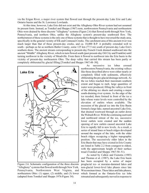
via the Erigan River, a major river system that flowed east through the present-day Lake <strong>Erie</strong> and Lake<br />
Ontario basins and the St. Lawrence Lowlands.<br />
At this time, however, Lake <strong>Erie</strong> did not exist and the Allegheny-Ohio River system had not assumed<br />
its present form. Instead, as Tomikel and Shepps (1967) note, northwestern Pennsylvania and northeastern<br />
Ohio were drained by three discrete "Allegheny" systems (Figure 2.6) that flowed north through New York,<br />
Pennsylvania, and northern Ohio, unlike the Allegheny system's present-day southward flow. The<br />
northernmost of these systems is the only one of these systems that is thought to have traversed the study area,<br />
specifically in the general vicinity of Elk and Conneaut Creeks. The catchment area of this ancient river was<br />
much larger than that of those present-day creeks, and ca. 18,000 B.P. it probably extended well to<br />
south—perhaps as far as northern Butler County, some 125 km (77.5 mi) south of present-day Lake <strong>Erie</strong>'s<br />
southern shore. The ancient stream corresponding to present-day French Creek drained southward into the<br />
ancient "Middle" Allegheny River, which in turn flowed south (past present-day Oil City and Franklin) until<br />
turning northwest in the vicinity of Meadville. From there it flowed to northwest into the <strong>Erie</strong> basin in the<br />
vicinity of present-day northeastern Ohio. The deep valley that carried this stream has been partly or<br />
completely obliterated by glacial filling [Tomikel and Shepps 1967:48–50].<br />
As successive ice lobes crossed<br />
northwestern Pennsylvania, the existing valleys<br />
like those described above were either nearly or<br />
completely filled with sediments, effectively<br />
obliterating the pre-glacial drainage network. As<br />
the ice lobes reached their maximum southern<br />
extent and began to melt, large quantities of<br />
water were produced, filling the valleys in front<br />
of the ablating ice sheets and creating a major<br />
south-draining river system. As the edge of the<br />
ice receded, there formed in front of the ice a<br />
lake whose water levels were controlled by the<br />
elevation of outlets where available. The<br />
recession of the glacial ice into the <strong>Erie</strong> Basin<br />
formed a large lake, named ancestral Lake <strong>Erie</strong>,<br />
that drained westward through an outlet down<br />
the Wabash River. With the continuing eastward<br />
and northward retreat of the ice, successive<br />
lower outlets were created and the sudden<br />
opening of new outlets caused ancestral Lake<br />
<strong>Erie</strong> to rapidly fall to new levels. As a result, a<br />
series of strand lines or beach ridges developed<br />
around the margin of the lake, with the older<br />
beach ridges occupying a higher topographic<br />
position. The successively older lakes in the<br />
<strong>Erie</strong> Basin that may have existed in <strong>Erie</strong> County<br />
are listed in Table 2.2 from youngest to oldest,<br />
with the approximate height of their surface<br />
tread (Tomikel and Shepps 1967:50–51).<br />
As noted by Calkin and Feenstra (1985)<br />
and Thomas et al. (1987), the Lake <strong>Erie</strong> basin<br />
Figure 2.6. Schematic configuration of the three discrete<br />
"Allegheny" systems that flowed north through New York,<br />
Pennsylvania, Northwestern West Virginia, and<br />
northeastern Ohio: (1) upper, (2) middle, and (3) lower<br />
(adapted from Tomikel and Shepps 1976:Figure 34).<br />
14<br />
has been occupied by a series of major<br />
proglacial ice- or moraine-dammed lakes and<br />
non-glacial lower-level lake phases since late<br />
Wisconsinan times. These lakes and lake phases,<br />
which formed as the Ontario-<strong>Erie</strong> ice lobe<br />
retreated and subsequently moved in response to


