

Final Report - VHB.com
Final Report - VHB.com
Final Report - VHB.com

You also want an ePaper? Increase the reach of your titles
YUMPU automatically turns print PDFs into web optimized ePapers that Google loves.
experience moderate seasonal variation because they serve a <strong>com</strong>bination of<br />
<strong>com</strong>muter and recreational traffic. Group III roadways are defined as recreational<br />
roadways and experience significant seasonal variation. Most of the Study Area<br />
roadways (i.e., State Route 196, US Route 201, State Route 24, and Gurnet Road) are<br />
considered Group I roadways. Pleasant Street (i.e., US Route 1) is considered a<br />
Group II roadway and Harpswell Road (i.e., State Route 123) is considered a<br />
<strong>com</strong>bination of Group I and Group II roadways.<br />
Weekday-evening peak-hour traffic volumes collected for this Feasibility Study were<br />
adjusted to reflect the DHV (i.e., 30th-highest hour volume) using “Weekly Group<br />
Mean Factors” provided by the MaineDOT. The 30th-highest hour approximates the<br />
6th-highest week identified in the MaineDOT’s “Weekly Group Mean Factors,”<br />
which generally corresponds to a summer condition. Some of the raw-count data<br />
<strong>com</strong>piled for this Feasibility Study were collected during Summer 2010 conditions<br />
and therefore did not require an adjustment to represent a DHV condition. Data<br />
collected in other months were adjusted by as little as 2 percent and as much as 25<br />
percent to represent the DHV condition.<br />
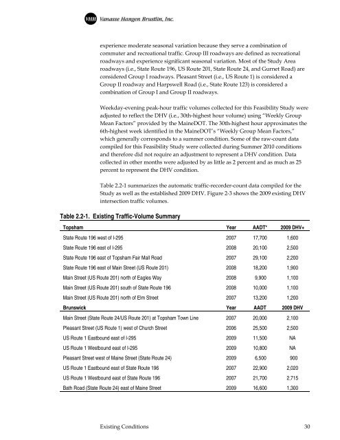
Table 2.2-1 summarizes the automatic traffic-recorder-count data <strong>com</strong>piled for the<br />
Study as well as the established 2009 DHV. Figure 2-3 shows the 2009 existing DHV<br />
intersection traffic volumes.<br />
Table 2.2-1. Existing Traffic-Volume Summary<br />
Topsham Year AADT* 2009 DHV+<br />
State Route 196 west of I-295 2007 17,700 1,600<br />
State Route 196 east of I-295 2008 20,100 2,500<br />
State Route 196 east of Topsham Fair Mall Road 2007 29,100 2,200<br />
State Route 196 east of Main Street (US Route 201) 2008 18,200 1,900<br />
Main Street (US Route 201) north of Eagles Way 2008 9,900 1,100<br />
Main Street (US Route 201) south of State Route 196 2008 10,000 1,100<br />
Main Street (US Route 201) north of Elm Street 2007 13,200 1,200<br />
Brunswick Year AADT 2009 DHV<br />
Main Street (State Route 24/US Route 201) at Topsham Town Line 2007 20,000 2,100<br />
Pleasant Street (US Route 1) west of Church Street 2006 25,500 2,500<br />
US Route 1 Eastbound east of I-295 2009 11,500 NA<br />
US Route 1 Westbound east of I-295 2009 10,800 NA<br />
Pleasant Street west of Maine Street (State Route 24) 2009 6,500 900<br />
US Route 1 Eastbound east of State Route 196 2007 22,900 2,020<br />
US Route 1 Westbound east of State Route 196 2007 21,700 2,715<br />
Bath Road (State Route 24) east of Maine Street 2009 16,600 1,300<br />
Existing Conditions 30


