Katoomba Charrette Outcomes Report - Blue Mountains City Council
Katoomba Charrette Outcomes Report - Blue Mountains City Council
Katoomba Charrette Outcomes Report - Blue Mountains City Council

You also want an ePaper? Increase the reach of your titles
YUMPU automatically turns print PDFs into web optimized ePapers that Google loves.
<strong>Katoomba</strong> <strong>Charrette</strong> <strong>Report</strong> & Town Centre Strategy<br />
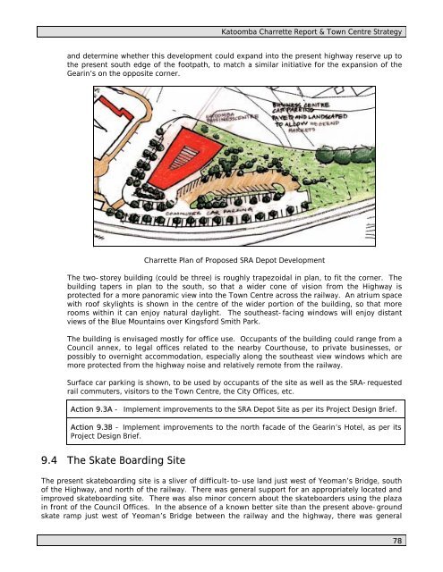
and determine whether this development could expand into the present highway reserve up to<br />
the present south edge of the footpath, to match a similar initiative for the expansion of the<br />
Gearin’s on the opposite corner.<br />
<strong>Charrette</strong> Plan of Proposed SRA Depot Development<br />
The two-storey building (could be three) is roughly trapezoidal in plan, to fit the corner. The<br />
building tapers in plan to the south, so that a wider cone of vision from the Highway is<br />
protected for a more panoramic view into the Town Centre across the railway. An atrium space<br />
with roof skylights is shown in the centre of the wider portion of the building, so that more<br />
rooms within it can enjoy natural daylight. The southeast-facing windows will enjoy distant<br />
views of the <strong>Blue</strong> <strong>Mountains</strong> over Kingsford Smith Park.<br />
The building is envisaged mostly for office use. Occupants of the building could range from a<br />
<strong>Council</strong> annex, to legal offices related to the nearby Courthouse, to private businesses, or<br />
possibly to overnight accommodation, especially along the southeast view windows which are<br />
more protected from the highway noise and relatively remote from the railway.<br />
Surface car parking is shown, to be used by occupants of the site as well as the SRA-requested<br />
rail commuters, visitors to the Town Centre, the <strong>City</strong> Offices, etc.<br />
Action 9.3A - Implement improvements to the SRA Depot Site as per its Project Design Brief.<br />
Action 9.3B - Implement improvements to the north facade of the Gearin’s Hotel, as per its<br />
Project Design Brief.<br />
9.4 The Skate Boarding Site<br />
The present skateboarding site is a sliver of difficult-to-use land just west of Yeoman’s Bridge, south<br />
of the Highway, and north of the railway. There was general support for an appropriately located and<br />
improved skateboarding site. There was also minor concern about the skateboarders using the plaza<br />
in front of the <strong>Council</strong> Offices. In the absence of a known better site than the present above-ground<br />
skate ramp just west of Yeoman’s Bridge between the railway and the highway, there was general<br />
78