


Create successful ePaper yourself
Turn your PDF publications into a flip-book with our unique Google optimized e-Paper software.
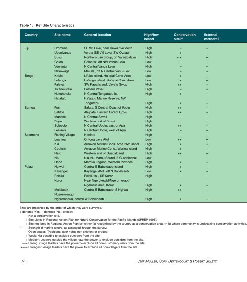
Table 1.<br />
Key Site Characteristics<br />
Country Site name General location High/low Conservation External<br />
island site 1 partners<br />
Fiji Dromuna SE Viti Levu, near Rewa river delta High – –<br />
Ucunivanua Verata (SE Viti Levu, SW Ovalau) High + +<br />
Susui Northern Lau group, <strong>of</strong>f Vanuabalavu High + + –<br />
Galoa Galoa Isl, <strong>of</strong>f NW Vanua Levu Low – –<br />
Vunivutu N Central Vanua Levu High – –<br />
Nakawaga Mali Isl., <strong>of</strong>f N Central Vanua Levu Low – +<br />
Tonga Koulo Lifuka Island, Ha’apai Cons. Area Low + –<br />
L<strong>of</strong>anga L<strong>of</strong>anga Island, Ha’apai Cons. Area Low + –<br />
Falevai SW Kapa Island, Vava’u Group High ++ +<br />
Tu’anekivale Eastern Vava’u High – –<br />
Nukuhetulu N Central Tongatapu Isl. High + +<br />
Ha’atafu<br />
Ha’atafu Marine Reserve, NW<br />
Tongatapu High + +<br />
Samoa Fusi Safata, S Central Coast <strong>of</strong> Upolu High ++ +<br />
Satitoa Aleipata, Eastern End <strong>of</strong> Upolu High ++ +<br />
Manase N Central Savaii High – –<br />
Papa Western end <strong>of</strong> Savaii High – –<br />
Solosolo N Central Upolu, east <strong>of</strong> Apia High ++ +<br />
Lealaalii N Central Upolu, west <strong>of</strong> Apia High – –<br />
Solomons Fishing Village Honiara High – –<br />
Luaniua Ontong Java Atoll Low ++ –<br />
Kia Arnavon Marine Cons. Area, NW Isabel High + +<br />
Cooksin Arnavon Marine Cons., Wagina Island High + +<br />
Naro Western end <strong>of</strong> Guadalcanal High ++ –<br />
Niu Niu Isl., Marau Sound, E Guadalcanal Low – –<br />
Onne Marovo Lagoon, Western Province High + +<br />
Palau Ngiwal Central E Babeldaob Island High + +<br />
Kayangel Kayangel Atoll, <strong>of</strong>f N Babeldaob Low + +<br />
Peleliu Peleliu Isl., SE Koror High – –<br />
Koror<br />
Near Ngerukewid/Ngerumekaol/<br />
Ngemelis area, Koror High + +<br />
Melekeok Central E Babeldaob, S Ngirwal High ++ –<br />
Ngaremlengui<br />
Ngeremeduu, central W Babeldaob High + +<br />
Sites are presented by the order <strong>of</strong> which they were surveyed.<br />
+ denotes ‘Yes’; – denotes ‘No’, except:<br />
1<br />
– Not a conservation site.<br />
+ Site Listed in Regional Action Plan for Nature Conservation for the Pacific Islands (SPREP 1998).<br />
++ Site not listed in Regional Action Plan but either (a) recognized by the country as a conservation area; or (b) where community is undertaking conservation activities.<br />
2<br />
– Strength <strong>of</strong> marine tenure, as assessed through the survey:<br />
– Open access: Traditional user rights non-existent or eroded.<br />
+ Weak: Not possible to exclude outsiders from the site.<br />
++ Medium: Leaders outside the village have the power to exclude outsiders from the site.<br />
+++ Strong: village leaders have the power to exclude all non-customary users from the site.<br />
++++ Strongest: village leaders have the power to exclude all non-villagers from the site.<br />
168<br />
JEFF MULLER, SOFIA BETTENCOURT & ROBERT GILLETT:


