

Vegetation Classification and Mapping Project Report - USGS
Vegetation Classification and Mapping Project Report - USGS
Vegetation Classification and Mapping Project Report - USGS

You also want an ePaper? Increase the reach of your titles
YUMPU automatically turns print PDFs into web optimized ePapers that Google loves.
<strong>Vegetation</strong> <strong>Classification</strong> <strong>and</strong> Distribution <strong>Mapping</strong> <strong>Report</strong>: Petrified Forest National Park<br />
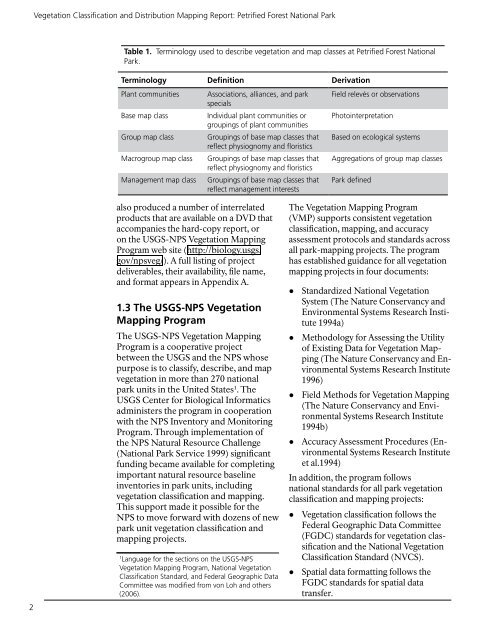
Table 1. Terminology used to describe vegetation <strong>and</strong> map classes at Petrified Forest National<br />
Park.<br />
Terminology Definition Derivation<br />
Plant communities<br />
Base map class<br />
Group map class<br />
Macrogroup map class<br />
Management map class<br />
Associations, alliances, <strong>and</strong> park<br />
specials<br />
Individual plant communities or<br />
groupings of plant communities<br />
Groupings of base map classes that<br />
reflect physiognomy <strong>and</strong> floristics<br />
Groupings of base map classes that<br />
reflect physiognomy <strong>and</strong> floristics<br />
Groupings of base map classes that<br />
reflect management interests<br />
Field relevés or observations<br />
Photointerpretation<br />
Based on ecological systems<br />
Aggregations of group map classes<br />
Park defined<br />
2<br />
also produced a number of interrelated<br />
products that are available on a DVD that<br />
accompanies the hard-copy report, or<br />
on the <strong>USGS</strong>-NPS <strong>Vegetation</strong> <strong>Mapping</strong><br />
Program web site (http://biology.usgs.<br />
gov/npsveg/). A full listing of project<br />
deliverables, their availability, file name,<br />
<strong>and</strong> format appears in Appendix A.<br />
1.3 The <strong>USGS</strong>-NPS <strong>Vegetation</strong><br />
<strong>Mapping</strong> Program<br />
The <strong>USGS</strong>-NPS <strong>Vegetation</strong> <strong>Mapping</strong><br />
Program is a cooperative project<br />
between the <strong>USGS</strong> <strong>and</strong> the NPS whose<br />
purpose is to classify, describe, <strong>and</strong> map<br />
vegetation in more than 270 national<br />
park units in the United States 1 . The<br />
<strong>USGS</strong> Center for Biological Informatics<br />
administers the program in cooperation<br />
with the NPS Inventory <strong>and</strong> Monitoring<br />
Program. Through implementation of<br />
the NPS Natural Resource Challenge<br />
(National Park Service 1999) significant<br />
funding became available for completing<br />
important natural resource baseline<br />
inventories in park units, including<br />
vegetation classification <strong>and</strong> mapping.<br />
This support made it possible for the<br />
NPS to move forward with dozens of new<br />
park unit vegetation classification <strong>and</strong><br />
mapping projects.<br />
The <strong>Vegetation</strong> <strong>Mapping</strong> Program<br />
(VMP) supports consistent vegetation<br />
classification, mapping, <strong>and</strong> accuracy<br />
assessment protocols <strong>and</strong> st<strong>and</strong>ards across<br />
all park-mapping projects. The program<br />
has established guidance for all vegetation<br />
mapping projects in four documents:<br />
● St<strong>and</strong>ardized National <strong>Vegetation</strong><br />
System (The Nature Conservancy <strong>and</strong><br />
Environmental Systems Research Institute<br />
1994a)<br />
● Methodology for Assessing the Utility<br />
of Existing Data for <strong>Vegetation</strong> <strong>Mapping</strong><br />
(The Nature Conservancy <strong>and</strong> Environmental<br />
Systems Research Institute<br />
1996)<br />
● Field Methods for <strong>Vegetation</strong> <strong>Mapping</strong><br />
(The Nature Conservancy <strong>and</strong> Environmental<br />
Systems Research Institute<br />
1994b)<br />
● Accuracy Assessment Procedures (Environmental<br />
Systems Research Institute<br />
et al.1994)<br />
In addition, the program follows<br />
national st<strong>and</strong>ards for all park vegetation<br />
classification <strong>and</strong> mapping projects:<br />
● <strong>Vegetation</strong> classification follows the<br />
Federal Geographic Data Committee<br />
(FGDC) st<strong>and</strong>ards for vegetation classification<br />
<strong>and</strong> the National <strong>Vegetation</strong><br />
1<br />
Language for the sections on the <strong>USGS</strong>-NPS <strong>Classification</strong> St<strong>and</strong>ard (NVCS).<br />
<strong>Vegetation</strong> <strong>Mapping</strong> Program, National <strong>Vegetation</strong><br />
● Spatial data formatting follows the<br />
<strong>Classification</strong> St<strong>and</strong>ard, <strong>and</strong> Federal Geographic Data<br />
Committee was modified from von Loh <strong>and</strong> others FGDC st<strong>and</strong>ards for spatial data<br />
(2006). transfer.


