

Vegetation Classification and Mapping Project Report - USGS
Vegetation Classification and Mapping Project Report - USGS
Vegetation Classification and Mapping Project Report - USGS

Create successful ePaper yourself
Turn your PDF publications into a flip-book with our unique Google optimized e-Paper software.
2 Identification <strong>and</strong> <strong>Classification</strong> of Plant Communities<br />
2.1 Methods<br />
The classification team, consisting of<br />
ecologists M.L. McTeague <strong>and</strong> A. Cully,<br />
identified <strong>and</strong> classified plant communities<br />
of Petrified Forest National Park (PEFO)<br />
to the finest floristic level possible. They<br />
used three approaches:<br />
1. reanalysis of relevé data collected in<br />
1996<br />
2. new field data collection, analysis, <strong>and</strong><br />
quantitative classification<br />
3. direct field observation during photointerpretation<br />
for one-plant communities<br />
(see section 3 Base Map Class<br />
Development)<br />
All plant communities, whether identified<br />
through quantitative classification or<br />
direct observation, were reconciled with<br />
the current NatureServe Explorer registry<br />
of NVC alliances <strong>and</strong> associations, <strong>and</strong><br />
reviewed for compatibility by K. Schulz of<br />
NatureServe. New plant assemblages were<br />
classified as park specials if they were not<br />
supported by suffcient observation data<br />
to be identified to an existing alliance or<br />
association or to be identified as a new, or<br />
provisional, plant community.<br />
to the results of the quantitative analysis<br />
of newly collected data <strong>and</strong> were<br />
provisionally assigned plant communities<br />
at the same time (see “Quantitative data<br />
analysis” below).<br />
2.1.1.2 Newly Collected Data<br />
In 2003, a field team led by M. McTeague<br />
collected plant-community data in the<br />
form of cover/abundance values for<br />
individual plant species in 149 relevé<br />
plots (Mueller-Dombois <strong>and</strong> Ellenburg<br />
2002) (see sample datasheet in the project<br />
DVD). The sampling design stratified the<br />
park l<strong>and</strong>scape into unique biophysical<br />
types for relevé allocation. This approach<br />
assumed that environmental variables<br />
drive vegetation patterns at PEFO <strong>and</strong> that<br />
a stratification based on environmental<br />
variables would assure adequate sampling<br />
across the range of plant-community<br />
variability. The biophysical types were<br />
derived by layering spatial data for aspect,<br />
elevation, watercourse presence, <strong>and</strong><br />
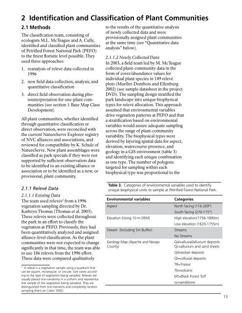
geology in a GIS environment (table 3)<br />
<strong>and</strong> identifying each unique combination<br />
as one type. The number of polygons<br />
targeted for sampling within each<br />
biophysical type was proportional to the<br />
Table 3. Categories of environmental variables used to identify<br />
2.1.1 Relevé Data unique biophysical units to sample at Petrified Forest National Park.<br />
2.1.1.1 Existing Data<br />
The team used relevés 2 from a 1996<br />
vegetation sampling directed by Dr.<br />
Kathryn Thomas (Thomas et al. 2003).<br />
These relevés were collected throughout<br />
the park in an effort to classify the<br />
vegetation at PEFO. Previously, they had<br />
been quantitatively analyzed <strong>and</strong> assigned<br />
alliance-level classification. As the plant<br />
communities were not expected to change<br />
significantly in that time, the team was able<br />
to use 186 relevés from the 1996 effort.<br />
These data were compared qualitatively<br />
2<br />
A relevé is a vegetation sample using a quadrant that<br />
can be square, rectangular, or circular. Size varies according<br />
to the type of vegetation being sampled. Relevés are<br />
usually placed non-r<strong>and</strong>omly in a uniform <strong>and</strong> representative<br />
sample of the vegetation being sampled. They are<br />
distinguished from line-transects <strong>and</strong> completely r<strong>and</strong>om<br />
sampling (Kent an Coker 1992).<br />
Environmental variables<br />
Categories<br />
Aspect North facing (116-269°)<br />
South facing (270-115°)<br />
Elevation (Using 10 m DEM)<br />
High elevation(1756-1890m)<br />
Low elevation (1620-1755m)<br />
Stream (Including 5m Buffer)<br />
Streams<br />
No Streams<br />
Geology Map (Apache <strong>and</strong> Navajo<br />
County)<br />
Qal=alluvial/alluvium deposits<br />
Qc=alluvium <strong>and</strong> s<strong>and</strong> sheets<br />
Qd=eolian deposits<br />
Ql=colluvial deposits<br />
TR=Triassic<br />
Tb=volcanic<br />
bft=Black Forest Tuff<br />
ss=s<strong>and</strong>stone<br />
13


