

Vegetation Classification and Mapping Project Report - USGS
Vegetation Classification and Mapping Project Report - USGS
Vegetation Classification and Mapping Project Report - USGS

You also want an ePaper? Increase the reach of your titles
YUMPU automatically turns print PDFs into web optimized ePapers that Google loves.
<strong>Vegetation</strong> <strong>Classification</strong> <strong>and</strong> Distribution <strong>Mapping</strong> <strong>Report</strong>: Petrified Forest National Park<br />
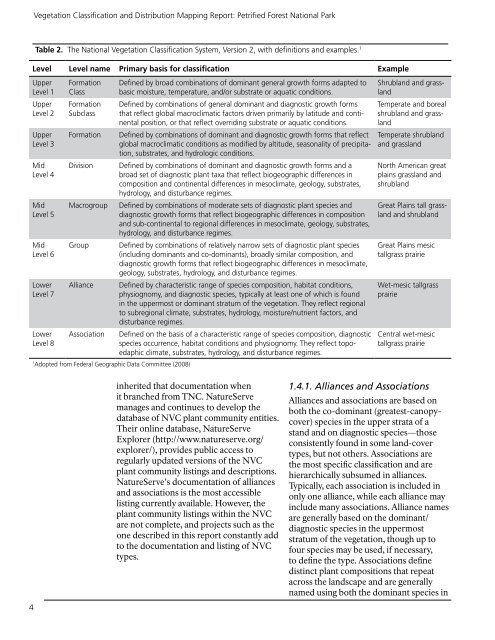
Table 2. The National <strong>Vegetation</strong> <strong>Classification</strong> System, Version 2, with definitions <strong>and</strong> examples. 1<br />
Level Level name Primary basis for classification Example<br />
Upper<br />
Level 1<br />
Upper<br />
Level 2<br />
Upper<br />
Level 3<br />
Mid<br />
Level 4<br />
Mid<br />
Level 5<br />
Mid<br />
Level 6<br />
Lower<br />
Level 7<br />
Lower<br />
Level 8<br />
Formation<br />
Class<br />
Formation<br />
Subclass<br />
Formation<br />
Division<br />
Macrogroup<br />
Group<br />
Alliance<br />
Association<br />
1<br />
Adopted from Federal Geographic Data Committee (2008)<br />
Defined by broad combinations of dominant general growth forms adapted to<br />
basic moisture, temperature, <strong>and</strong>/or substrate or aquatic conditions.<br />
Defined by combinations of general dominant <strong>and</strong> diagnostic growth forms<br />
that reflect global macroclimatic factors driven primarily by latitude <strong>and</strong> continental<br />
position, or that reflect overriding substrate or aquatic conditions.<br />
Defined by combinations of dominant <strong>and</strong> diagnostic growth forms that reflect<br />
global macroclimatic conditions as modified by altitude, seasonality of precipitation,<br />
substrates, <strong>and</strong> hydrologic conditions.<br />
Defined by combinations of dominant <strong>and</strong> diagnostic growth forms <strong>and</strong> a<br />
broad set of diagnostic plant taxa that reflect biogeographic differences in<br />
composition <strong>and</strong> continental differences in mesoclimate, geology, substrates,<br />
hydrology, <strong>and</strong> disturbance regimes.<br />
Defined by combinations of moderate sets of diagnostic plant species <strong>and</strong><br />
diagnostic growth forms that reflect biogeographic differences in composition<br />
<strong>and</strong> sub-continental to regional differences in mesoclimate, geology, substrates,<br />
hydrology, <strong>and</strong> disturbance regimes.<br />
Defined by combinations of relatively narrow sets of diagnostic plant species<br />
(including dominants <strong>and</strong> co-dominants), broadly similar composition, <strong>and</strong><br />
diagnostic growth forms that reflect biogeographic differences in mesoclimate,<br />
geology, substrates, hydrology, <strong>and</strong> disturbance regimes.<br />
Defined by characteristic range of species composition, habitat conditions,<br />
physiognomy, <strong>and</strong> diagnostic species, typically at least one of which is found<br />
in the uppermost or dominant stratum of the vegetation. They reflect regional<br />
to subregional climate, substrates, hydrology, moisture/nutrient factors, <strong>and</strong><br />
disturbance regimes.<br />
Defined on the basis of a characteristic range of species composition, diagnostic<br />
species occurrence, habitat conditions <strong>and</strong> physiognomy. They reflect topoedaphic<br />
climate, substrates, hydrology, <strong>and</strong> disturbance regimes.<br />
Shrubl<strong>and</strong> <strong>and</strong> grassl<strong>and</strong><br />
Temperate <strong>and</strong> boreal<br />
shrubl<strong>and</strong> <strong>and</strong> grassl<strong>and</strong><br />
Temperate shrubl<strong>and</strong><br />
<strong>and</strong> grassl<strong>and</strong><br />
North American great<br />
plains grassl<strong>and</strong> <strong>and</strong><br />
shrubl<strong>and</strong><br />
Great Plains tall grassl<strong>and</strong><br />
<strong>and</strong> shrubl<strong>and</strong><br />
Great Plains mesic<br />
tallgrass prairie<br />
Wet-mesic tallgrass<br />
prairie<br />
Central wet-mesic<br />
tallgrass prairie<br />
4<br />
inherited that documentation when<br />
it branched from TNC. NatureServe<br />
manages <strong>and</strong> continues to develop the<br />
database of NVC plant community entities.<br />
Their online database, NatureServe<br />
Explorer (http://www.natureserve.org/<br />
explorer/), provides public access to<br />
regularly updated versions of the NVC<br />
plant community listings <strong>and</strong> descriptions.<br />
NatureServe’s documentation of alliances<br />
<strong>and</strong> associations is the most accessible<br />
listing currently available. However, the<br />
plant community listings within the NVC<br />
are not complete, <strong>and</strong> projects such as the<br />
one described in this report constantly add<br />
to the documentation <strong>and</strong> listing of NVC<br />
types.<br />
1.4.1. Alliances <strong>and</strong> Associations<br />
Alliances <strong>and</strong> associations are based on<br />
both the co-dominant (greatest-canopycover)<br />
species in the upper strata of a<br />
st<strong>and</strong> <strong>and</strong> on diagnostic species—those<br />
consistently found in some l<strong>and</strong>-cover<br />
types, but not others. Associations are<br />
the most specific classification <strong>and</strong> are<br />
hierarchically subsumed in alliances.<br />
Typically, each association is included in<br />
only one alliance, while each alliance may<br />
include many associations. Alliance names<br />
are generally based on the dominant/<br />
diagnostic species in the uppermost<br />
stratum of the vegetation, though up to<br />
four species may be used, if necessary,<br />
to define the type. Associations define<br />
distinct plant compositions that repeat<br />
across the l<strong>and</strong>scape <strong>and</strong> are generally<br />
named using both the dominant species in


