

Vegetation Classification and Mapping Project Report - USGS
Vegetation Classification and Mapping Project Report - USGS
Vegetation Classification and Mapping Project Report - USGS

Create successful ePaper yourself
Turn your PDF publications into a flip-book with our unique Google optimized e-Paper software.
G22<br />
B19 Alkali Sacaton - Blue Grama Herbaceous <strong>Vegetation</strong><br />
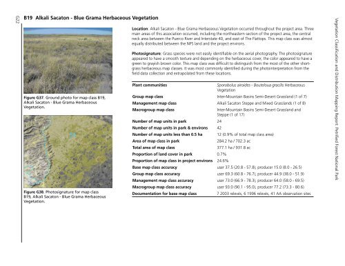
Figure.G37..Ground.photo.for.map.class.B19,.<br />
Alkali.Sacaton.-.Blue.Grama.Herbaceous.<br />
<strong>Vegetation</strong>.<br />
Figure.G38..Photosignature.for.map.class.<br />
B19,.Alkali.Sacaton.-.Blue.Grama.Herbaceous.<br />
<strong>Vegetation</strong>.<br />
Location: Alkali Sacaton - Blue Grama Herbaceous <strong>Vegetation</strong> occurred throughout the project area. Three<br />
main areas of this association occurred, including the northeastern section of the project area, the central<br />
neck area between the Puerco River <strong>and</strong> Interstate 40, <strong>and</strong> east of The Flattops. This map class was almost<br />
equally distributed between the NPS l<strong>and</strong> <strong>and</strong> the project environs.<br />
Photosignature: Grass species were not easily identifiable on the aerial photography. The photosignature<br />
appeared to have a smooth texture <strong>and</strong> depending on the herbaceous cover, the color appeared to have a<br />
green to grayish brown color. This map class was difficult to distinguish from the most of the other shortgrass<br />
herbaceous map classes. It was most commonly identified during the photointerpretation from the<br />
field data collection <strong>and</strong> extrapolated from these locations.<br />
Plant communities<br />
Sporobolus airoides - Bouteloua gracilis Herbaceous<br />
<strong>Vegetation</strong><br />
Group map class Inter-Mountain Basins Semi-Desert Grassl<strong>and</strong> (1 of 7)<br />
Management map class Alkali Sacaton Steppe <strong>and</strong> Mixed Grassl<strong>and</strong>s (1 of 8)<br />
Macrogroup map class<br />
Inter-Mountain Basins Semi-Desert Grassl<strong>and</strong> <strong>and</strong><br />
Steppe (1 of 17)<br />
Number of map units in park 24<br />
Number of map units in park & environs 42<br />
Number of map units less than 0.5 ha 12 (0.9% of total map class area)<br />
Area of map class in park<br />
284.2 ha / 702.3 ac<br />
Total area of map class<br />
377.1 ha / 931.8 ac<br />
Proportion of l<strong>and</strong> cover in park 0.7%<br />
Proportion of map class in project environs 24.6%<br />
Base map class accuracy user 37.5 (20.8 - 57.8), producer 15.0 (8.0 - 26.5)<br />
Group map class accuracy user 69.3 (60.8 - 76.7), producer 44.9 (38.0 - 51.9)<br />
Management map class accuracy user 73.0 (66.9 - 78.3), producer 64.0 (58.0 - 69.5)<br />
Macrogroup map class accuracy user 93.0 (90.1 - 95.0), producer 77.2 (73.3 - 80.6)<br />
Documentation for base map class<br />
7 2003 relevés, 6 1996 relevés, 41 AA observation sites<br />
<strong>Vegetation</strong> <strong>Classification</strong> <strong>and</strong> Distribution <strong>Mapping</strong> <strong>Report</strong>: Petrified Forest National Park


