

Vegetation Classification and Mapping Project Report - USGS
Vegetation Classification and Mapping Project Report - USGS
Vegetation Classification and Mapping Project Report - USGS

Create successful ePaper yourself
Turn your PDF publications into a flip-book with our unique Google optimized e-Paper software.
B2 One-seed Juniper / Bigelow’s Sagebrush Shrubl<strong>and</strong><br />
Location: One-seed Juniper / Bigelow’s Sagebrush Shrubl<strong>and</strong> was located throughout the park <strong>and</strong> its<br />
environs in a few small to large map units. These map units tended to occur on higher elevation mesas <strong>and</strong><br />
plateaus <strong>and</strong> were most frequent on Chinde Mesa, Headquarters Mesa, <strong>and</strong> in the southwestern corner of<br />
the project area.<br />
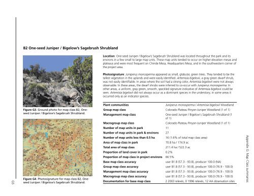
Photosignature: Juniperus monosperma appeared as small, globular, green trees. They tended to be the<br />
tallest vegetation in the upl<strong>and</strong>s <strong>and</strong> were easily identified. Artemisia bigelovii, a gray green dwarf shrub,<br />
was not easily identifiable. In areas where the soil had a strong color, Artemisia bigelovii were not always<br />
observable. In these areas, the dwarf shrubs were inferred to co-occur with Juniperus monosperma. In<br />
other areas, a uniform, gray green, smooth, speckled signature indicative of Artemisia bigelovii could be<br />
seen. Artemisia bigelovii did not always occur as a dominant species in the understory; in some areas it<br />
occurred only as an indicator species.<br />
G5<br />
Figure.G3..Ground.photo.for.map.class.B2,.Oneseed.Juniper./.Bigelow’s.Sagebrush.Shrubl<strong>and</strong>.<br />
Figure.G4..Photosignature.for.map.class.B2,.Oneseed.Juniper./.Bigelow’s.Sagebrush.Shrubl<strong>and</strong>.<br />
Plant communities<br />
Juniperus monosperma / Artemisia bigelovii Woodl<strong>and</strong><br />
Group map class Colorado Plateau Pinyon-Juniper Woodl<strong>and</strong> (1 of 1)<br />
Management map class One-seed Juniper / Bigelow's Sagebrush Shrubl<strong>and</strong> (1<br />
of 1)<br />
Macrogroup map class Colorado Plateau Pinyon-Juniper Woodl<strong>and</strong> (1 of 1)<br />
Number of map units in park 11<br />
Number of map units in park & environs 27<br />
Number of map units less than 0.5 ha 16 (1.6% of total map class area)<br />
Area of map class in park<br />
70.8 ha / 174.9 ac<br />
Total area of map class<br />
211.4 ha / 522.3 ac<br />
Proportion of l<strong>and</strong> cover in park 0.2%<br />
Proportion of map class in project environs 66.5%<br />
Base map class accuracy<br />
user 81.8 (57.3 - 93.8), producer 100.0 (NA)<br />
Group map class accuracy user 81.8 (57.3 - 93.8), producer 100.0 (76.9 - 100.0)<br />
Management map class accuracy user 81.8 (57.3 - 93.8), producer 100.0 (76.9 - 100.0)<br />
Macrogroup map class accuracy user 81.8 (57.3 - 93.8), producer 100.0 (76.9 - 100.0)<br />
Documentation for base map class<br />
2 2003 relevés, 0 1996 relevés, 12 AA observation sites<br />
Appendix G: Map Class summaries


