

Vegetation Classification and Mapping Project Report - USGS
Vegetation Classification and Mapping Project Report - USGS
Vegetation Classification and Mapping Project Report - USGS

Create successful ePaper yourself
Turn your PDF publications into a flip-book with our unique Google optimized e-Paper software.
G16<br />
B13 S<strong>and</strong>sage Colorado Plateau Shrubl<strong>and</strong><br />
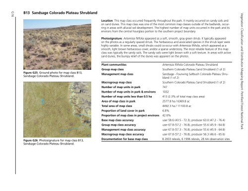
Figure.G25..Ground.photo.for.map.class.B13,.<br />
S<strong>and</strong>sage.Colorado.Plateau.Shrubl<strong>and</strong>.<br />
Figure.G26..Photosignature.for.map.class.B13,.<br />
S<strong>and</strong>sage.Colorado.Plateau.Shrubl<strong>and</strong>.<br />
Location: This map class occurred frequently throughout the park. It mainly occurred on s<strong>and</strong>y soils <strong>and</strong><br />
on s<strong>and</strong> dunes. This map class was one of the most common map classes outside of the badl<strong>and</strong>s, occurring<br />
in areas with alluvial soil development. The highest number of map units occurred in the park <strong>and</strong> its<br />
environs from the central hourglass portion to the southern project boundary.<br />
Photosignature: Artemisia filifolia appeared as a soft, smooth, gray green shrub. It typically appeared<br />
on the photos as a regularly spaced shrub. The herbaceous <strong>and</strong> associated species in the shrub layer were<br />
highly variable. In some areas, small shrubs could co-occur with Artemisia filifolia, which appeared as a<br />
smooth, light brown herbaceous cover, <strong>and</strong>/or a sparse understory. The most reliable feature of this map<br />
class was typically the s<strong>and</strong>y soils. The s<strong>and</strong>y soils were light brown with a soft texture. In areas with active<br />
s<strong>and</strong> dunes, the bumpy relief of the dunes was apparent on the photos.<br />
Plant communities<br />
Artemisia filifolia Colorado Plateau Shrubl<strong>and</strong><br />
Group map class Southern Colorado Plateau S<strong>and</strong> Shrubl<strong>and</strong> (1 of 2)<br />
Management map class<br />
S<strong>and</strong>sage - Fourwing Saltbush Colorado Plateau Shrubl<strong>and</strong><br />
(1 of 2)<br />
Macrogroup map class Southern Colorado Plateau S<strong>and</strong> Shrubl<strong>and</strong> (1 of 2)<br />
Number of map units in park 747<br />
Number of map units in park & environs 1032<br />
Number of map units less than 0.5 ha 413 (2.3% of total map class area)<br />
Area of map class in park<br />
2577.8 ha / 6369.8 ac<br />
Total area of map class<br />
4492.3 ha / 11100.8 ac<br />
Proportion of l<strong>and</strong> cover in park 6.8%<br />
Proportion of map class in project environs 42.6%<br />
Base map class accuracy user 58.6 (43.5 - 72.3), producer 63.0 (47.2 - 76.4)<br />
Group map class accuracy user 67.8 (57.2 - 76.8), producer 55.6 (45.9 - 64.8)<br />
Management map class accuracy user 67.8 (57.3 - 76.8), producer 55.6 (45.9 - 64.8)<br />
Macrogroup map class accuracy user 67.8 (57.2 - 76.8), producer 56.3 (46.6 - 65.6)<br />
Documentation for base map class<br />
8 2003 relevés, 6 1996 relevés, 28 AA observation sites<br />
<strong>Vegetation</strong> <strong>Classification</strong> <strong>and</strong> Distribution <strong>Mapping</strong> <strong>Report</strong>: Petrified Forest National Park


