

Vegetation Classification and Mapping Project Report - USGS
Vegetation Classification and Mapping Project Report - USGS
Vegetation Classification and Mapping Project Report - USGS

You also want an ePaper? Increase the reach of your titles
YUMPU automatically turns print PDFs into web optimized ePapers that Google loves.
Glossary<br />
Glossary modified from <strong>USGS</strong>-NPS<br />
<strong>Vegetation</strong> <strong>Mapping</strong> Program: http://<br />
biology.usgs.gov/npsveg/glossary.html.<br />
Accuracy: The closeness of results of<br />
observations, computations, or estimates<br />
to the true values or to values that are<br />
accepted as being true (Rabchevsky 1984).<br />
In the <strong>USGS</strong>-NPS <strong>Vegetation</strong> <strong>Mapping</strong><br />
Program there are two aspects of accuracy:<br />
thematic <strong>and</strong> positional accuracy.<br />
Accuracy assessment: The process of<br />
determining the positional <strong>and</strong> thematic<br />
accuracy of the spatial vegetation<br />
community data. This is an independent<br />
process performed after the vegetation<br />
mapping <strong>and</strong> classification is complete.<br />
Accuracy assessment point: A location<br />
where accuracy assessment data are<br />
collected.<br />
Aerial photography: Analog imagery<br />
taken from an airplane. The optical axis<br />
is oriented perpendicular to the earth’s<br />
surface so that the film is parallel to the<br />
surface being photographed. (also Vertical<br />
Aerial Photography). A sequence of aerial<br />
photographs will overlap so the photos<br />
can be used in stereoscopic analysis<br />
(stereo pairs). The overlap is referred to as<br />
“endlap” (top-to-bottom area in common,<br />
same flightline) <strong>and</strong> “sidelap” (side-toside<br />
area in common, different flightlines)<br />
(portions from Rabchevsky 1984). Aerial<br />
photography used in the program is 9 ×<br />
9-inch vertical, stereoscopic, color or color<br />
infrared photography.<br />
Alliance: A physiognomically uniform<br />
group of associations sharing one or<br />
more diagnostic (dominant, differential,<br />
indicator, or character) species that, as a<br />
rule, are found in the uppermost stratum<br />
of the vegetation (FGDC 1997). This is<br />
the second-finest level in the National<br />
<strong>Vegetation</strong> <strong>Classification</strong> St<strong>and</strong>ard<br />
hierarchy. See the table under USNVC.<br />
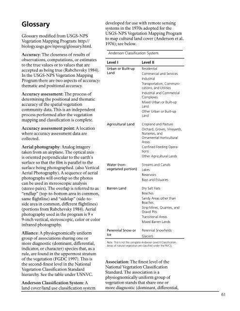
Anderson <strong>Classification</strong> System: A<br />
l<strong>and</strong> cover/l<strong>and</strong> use classification system<br />
developed for use with remote sensing<br />
systems in the 1970s adopted for the<br />
<strong>USGS</strong>-NPS <strong>Vegetation</strong> <strong>Mapping</strong> Program<br />
to map cultural l<strong>and</strong> cover (Anderson et al.<br />
1976); see below.<br />
Anderson <strong>Classification</strong> System.<br />
Level I<br />
Urban.or.Built-up.<br />
L<strong>and</strong><br />
Agricultural.L<strong>and</strong><br />
Water.(nonvegetated.portion)<br />
Barren.L<strong>and</strong><br />
Perennial.Snow.or.<br />
Ice<br />
Level II<br />
Residential<br />
Commercial <strong>and</strong> Services<br />
Industrial<br />
Transportation, Communications,<br />
<strong>and</strong> Utilities<br />
Industrial <strong>and</strong> Commercial<br />
Complexes<br />
Mixed Urban or Built-up<br />
L<strong>and</strong><br />
Other Urban or Built-up<br />
L<strong>and</strong><br />
Cropl<strong>and</strong> <strong>and</strong> Pasture<br />
Orchard, Groves, Vineyards,<br />
Nurseries, <strong>and</strong><br />
Ornamental Horticultural<br />
Areas<br />
Confined Feeding Operations<br />
Other Agricultural L<strong>and</strong>s<br />
Streams <strong>and</strong> Canals<br />
Lakes<br />
Reservoirs<br />
Bays <strong>and</strong> Estuaries<br />
Dry Salt Flats<br />
Beaches<br />
S<strong>and</strong>y Areas other than<br />
Beaches<br />
Strip Mines, Quarries, <strong>and</strong><br />
Gravel Pits<br />
Transitional Areas<br />
Mixed Barren L<strong>and</strong>s<br />
Perennial Snowfields<br />
Glaciers<br />
Note: This is not the complete Anderson Level II <strong>Classification</strong>.<br />
Areas of natural vegetation are classified under the NVCS.<br />
Association: The finest level of the<br />
National <strong>Vegetation</strong> <strong>Classification</strong><br />
St<strong>and</strong>ard. The association is a<br />
physiognomically uniform group of<br />
vegetation st<strong>and</strong>s that share one or<br />
more diagnostic (dominant, differential,<br />
61


