KETCHIKAN GATEWAY BOROUGH PLANNING COMMISSION ...
KETCHIKAN GATEWAY BOROUGH PLANNING COMMISSION ...
KETCHIKAN GATEWAY BOROUGH PLANNING COMMISSION ...

You also want an ePaper? Increase the reach of your titles
YUMPU automatically turns print PDFs into web optimized ePapers that Google loves.
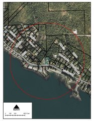
<strong>KETCHIKAN</strong> <strong>GATEWAY</strong> <strong>BOROUGH</strong> CODE 17.70.040Chapter 17.70CLUSTER SUBDIVISIONS – OPEN SPACESections:17.70.010 Generally.17.70.020 Permitted buildings and structures.17.70.030 Mandatory cluster open space land.17.70.040 Optional cluster open space land.17.70.050 General requirements.17.70.060 Ownership and administration of cluster open space.Cross Reference – Cluster Subdivision, Chapter 18.130 KGBC.17.70.010 Generally.Those areas within a cluster subdivision that are not devoted to individual dwelling unit lots, streets, or play areasshall remain as cluster open space in perpetuity. A minimum of twenty (20) percent of the net site area shall bedevoted to cluster open space. Cluster open space shall be used for conservation or for outdoor recreation purposesthat do not require structures, such as hiking or berry picking. No portion of any dwelling unit lot, street, or playarea shall be considered as cluster open space. [Ord. No. 711, §2, 9-18-89. Code 1974 §55.63.010.]17.70.020 Permitted buildings and structures.No buildings or structures shall be permitted within the cluster open space except:(a) Essential services as defined in KGBC 18.05.070.(b)(c)Streets, pedestrian paths, or bike paths.Required buffer yards developed in accordance with the requirements listed in Chapter 17.65 KGBC.(d) Fences. [Ord. No. 711, §2, 9-18-89. Code 1974 §55.63.020.]17.70.030 Mandatory cluster open space land.A minimum ten (10) foot strip of undisturbed land encompassing each side of the natural floodplain of Ketchikan,Carlanna, Hoadley and Whipple Creeks, measured from the one hundred (100) year floodplain mark, shall remainas cluster open space. Where the planning commission serving as the platting authority determines that a ten (10)foot strip is inadequate to provide for public safety or to preserve the aesthetic value of any of the aforementionedcreeks, a wider strip may be designated. The area encompassed by a creek buffer strip may be included in the calculationof required cluster open space. [Ord. No. 711, §2, 9-18-89. Code 1974 §55.63.030.]17.70.040 Optional cluster open space land.Land devoted to any of the following purposes may be included in the calculation of required cluster open space,subject to planning commission serving as the platting authority approval:(a)(b)(c)(d)Undisturbed land within three hundred thirty (330) feet of active eagle nesting trees identified by the U.S. Fishand Wildlife Service.Buffer yards between groups of residences within the cluster subdivision or between the subdivision and adjacentdevelopment.Greenbelt access corridors between the subdivision and the shoreline for both subdivision residents and wildlife.Preservation of scenic areas within the subdivision.17-49