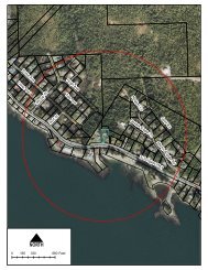
KETCHIKAN GATEWAY BOROUGH PLANNING COMMISSION ...
KETCHIKAN GATEWAY BOROUGH PLANNING COMMISSION ...
KETCHIKAN GATEWAY BOROUGH PLANNING COMMISSION ...

Create successful ePaper yourself
Turn your PDF publications into a flip-book with our unique Google optimized e-Paper software.
17.80.010 CLUSTER SUBDIVISIONS – PLATTING PROCEDUREChapter 17.80CLUSTER SUBDIVISIONS – PLATTING PROCEDURESections:17.80.010 Generally.17.80.020 Preapplication.17.80.030 Required submittals for preapplication conference.17.80.040 Preapplication report.Cross Reference – Cluster Subdivision, Chapter 18.130 KGBC.17.80.010 Generally.The preparation, submission, review, and official action concerning all cluster subdivision plats shall be as providedin Chapters 17.10 through 17.20 KGBC in addition to the requirements listed hereinafter. [Ord. No. 711, §2, 9-18-89. Code 1974 §55.65.010.]17.80.020 Preapplication.The preapplication procedure provided in KGBC 17.10.020 shall be mandatory for all cluster subdivisions. At thepreapplication conference the planning official shall review the proposed subdivision and advise the subdividerconcerning the compatibility of the subdivision with the intent and requirements of this title and other applicableregulations, including but not limited to the zoning ordinance and comprehensive plan. [Ord. No. 711, §2, 9-18-89.Code 1974 §55.65.020.]17.80.030 Required submittals for preapplication conference.(a) Mapped Submittals. A sketch plat drawn to a scale of not less than one (1) inch equals one hundred (100) feetand containing the following information:(1) Topography of the proposed subdivision with contour intervals that meet the following specifications:a. Two (2) foot contour intervals for slopes of zero (0) to twenty-five (25) percent.b. Five (5) foot contour intervals for slopes of twenty-five (25) percent to fifty (50) percent.c. Ten (10) foot contour intervals for slopes of fifty (50) percent and over.(2) The location of all water wells, laterals and private ditches, water bodies, washes, streams, lakes or saltwateron or within two hundred (200) feet of the boundaries of the proposed subdivision with directionof flow; and location and extent of areas subject to inundation. Such features shall be labeled accordingly.(3) Existing and proposed streets, pedestrian paths and bike paths.(4) Location of proposed buffer yards.(5) Location of proposed lots.(6) Proposed building locations.(7) Location of proposed cluster open space and proposed play areas with an indication as to whether thecluster open space or play area is proposed to be dedicated to the public or conveyed to a home owner’sassociation.(8) Approximate dimensions and square footage of each dwelling unit lot, play area, and cluster open space.17-52