KETCHIKAN GATEWAY BOROUGH PLANNING COMMISSION ...
KETCHIKAN GATEWAY BOROUGH PLANNING COMMISSION ...
KETCHIKAN GATEWAY BOROUGH PLANNING COMMISSION ...

Create successful ePaper yourself
Turn your PDF publications into a flip-book with our unique Google optimized e-Paper software.
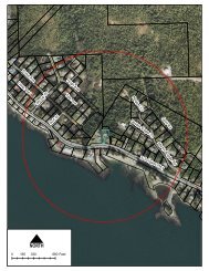
17.15.050 PLATTING PROCEDURES AND REQUIREMENTS – PRELIMINARY PLAT17.15.050 Required information.(a) Form and Scale. The preliminary plat shall be clear and legible black or blue line print. The size of the platshall not be greater than twenty-four (24) inches by thirty-six (36) inches. If more than one (1) sheet, all sheetsshall be the same size and scale. The mapped data for the plat shall be drawn to a scale of not less than one (1)inch equals one hundred (100) feet or not less than one (1) inch equals fifty (50) feet if the subdivision containsfour (4) lots or less. The preliminary plat must be accompanied by an application form incorporating the informationrequired by this title. Any information required by this title and not included on the preliminary platplan or application form shall be attached in letter form.(b)Identification Data. Title block shall contain the following information:(1) Name of proposed subdivision;(2) Lot, block and survey number and general descriptive location of land to be subdivided;(3) Name and address of the owner and subdivider of the land;(4) Name and address of the land surveyor preparing the plat;(5) Scale of drawing, north arrow and date of preparation.(c)(d)(e)Vicinity Map. A vicinity plan at a scale of one (1) inch equals fifteen hundred (1,500) feet or greater on a USGSquadrangle vicinity plan shall be provided. The vicinity sketch shall show the location of the subdivision inrelation to surrounding countryside and existing rights-of-way, roadways, structures, physical features, landmarksand U.S. Survey boundaries.Boundaries and Flood Elevation Data. All subdivisions of land located within the areas designated as specialflood hazard areas or other flood areas on the flood insurance rate map (FIRM) shall depict the exterior boundariesof such land located within such classifications on the preliminary plat, and shall also depict the baseflood elevations derived from the flood insurance rate map. Subdivisions of fifty (50) or more lots, or occupyingan area of five (5) or more acres, shall develop and depict base flood elevation data if such information isnot available from the official flood insurance rate map.Proposed Conditions Data.(1) Street layout, including location, width, grade and proposed names of all streets, alleys and other rightsof-waywith designation as to whether such are to be private or dedicated to the public.(2) Proposed easements and rights-of-way of any kind and their intended use. Proposed structures or areasreserved or intended for specific public or private purposes with designation as to whether such are to beprivate or dedicated to the public.(3) The layout, with all lot lines, the dimensions and square footage, of each lot and the total number of lots.Lots shall be numbered consecutively.(4) The proposed land use and zoning of each lot shall be indicated.(5) The location dimensions and use of all property proposed for reservations.(f)Proposed Utility Methods.(1) The proposed method of providing water supply and sewage disposal for the lots shall be indicated,including such data as necessary to satisfy the Department of Environmental Conservation. If such systemsare proposed to serve more than one (1) lot the following information must be submitted:17-24